Follow riverside paths, moorland tracks and a steep climb to reach Simon’s Seat for some wonderful views

Seen from the banks of the Wharfe, Simon’s Seat thrusts a great rocky prow out from the edge of Barden Fell. It draws the eye from anywhere along this stretch of the river, throwing down its clear challenge and promising the reward of spectacular views to those who accept it. This way of climbing it explores the best the area has to offer, gentle riverside paths, a steep ascent, wide open moorland and a delectable woodland stretch to finish.
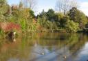
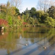
It starts from Barden Bridge, one of the most graceful crossings of the Wharfe. The current narrow span dates from the mid-17th century when it was built to replace an earlier crossing washed away by floods.
Directions

From the free parking area take the riverside path which meanders upstream through meadows to provide a gentle leg-loosening mile to Howgill. At the farm buildings, where the path meets the road cross over and head up the green lane which climbs between cottages to Howgill Lane. At the crossroads go straight over and continue uphill through a gate.
As the track snakes upwards ever-widening views of Wharfedale and the fells beyond are revealed. The track enters woodland and continues winding uphill to emerge on the open moor. At a junction take the rougher left hand track continuing to follow the wallside. As the path crests the moor there are once again stunning views down into the valley and the cleft of Troller’s Gill.
|
||||||||

As you reach a large cairn the gritstone tor of Simon’s Seat, topped by its trig point, suddenly leaps into view. From the trig point on its ,576ft/485m summit there is a vast 360 degree panorama stretching from Pendle Hill in Lancashire, across the Dales and the mushroom-like white golf balls of the Menwith Hill listening station and in the far distance the power stations of West Yorkshire. Closer to hand the village of Skyreholme lies at your feet. Choose which vista you prefer and settle down for a mid-walk break to admire it.
The descent path heads off south towards the obvious depression of the Valley of Desolation. Take the clear path at about 10 o’clock from the one by which you arrived. After half a mile at a T-junction, turn left and follow the broad Land Rover track as it heads downhill curling round the rim of the valley.
This section includes another inviting picnic stop built in a stone enclosure but if you decide to use it watch out for the wobbly top.
This long moorland stroll, a glorious sea of heather in late summer, ends at a gate leading into woodland. After a little over a quarter of a mile/0.5km by a broad turning circle on the forest road a signpost points the way leftwards to Waterfall Cottage.
Go through the gate and enter the Valley of Desolation, a lush woodland that has long outlived its dismal name. It was coined in 1826 after a storm levelled all its trees but Nature, and some careful replanting by the Bolton Abbey Estate have long since repaired the damage. Just as the path leaves the trees it passes close to the waterfall of Posforth Gill. To visit the fall it is necessary to divert across a stile over the wire fence and take a steep, rough and often slippery track where care is needed. The main path crosses fields to reach the road by Waterfall Cottage.
A few hundred yards to the left is a sign to the Cavendish Pavilion with refreshments and a large, pay parking area which can be used if Barden Bridge is full. Otherwise turn right downhill and at the bottom transfer to the footpath and turn right to follow it upstream. It climbs and dips through deciduous woods and leads all the way back to Barden Bridge. Along the way trees have been cleared to give a bird’s eye view of the chasm of The Strid where the Wharfe is channelled into a narrow cleft just a few feet wide. Every year its deceptively simple invitation tempts the bold and the foolhardy to try to leap across, sometimes with fatal consequences as they become trapped in the whirlpools. Further upstream is the distinctively crenelated aqueduct bridge before Barden Bridge and the guardian Barden Tower, once a stronghold of the Cliffords of Skipton Castle and now a restaurant, come into view.
NOTE: Barden Fell is used for shooting during the grouse season which runs from August 12th to December 10th which can lead to some of the permissive paths used on this walk being temporarily closed. A list of shooting dates is available from boltonabbey.com or the estate office on 01756 718000. Shooting does not take place on Sundays.
Fact file
Start/finish: Barden Bridge on the Bolton Abbey to Appletreewick road
Distance: 8.5miles/13.5km
Height gain: 1,200ft/370m
Time: 4 hours
Terrain: Riverside paths, moorland tracks. Steep climb to Simon’s Seat
Parking: Free parking at Barden Bridge but can fill up early at weekends, more spaces on Bolton Abbey to Burnsall road, large pay parking area at Cavendish Pavilion
Refreshments at Cavendish Pavilion and Bolton Abbey