Expect big skies, a summit challenge of sorts and amazing views on this walk to the highest point on the North York Moors.

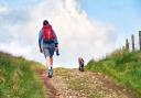
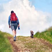
Eager for adventure, my teenage son prefers walks up what he calls shapely peaks. Round Hill (the clue’s in the name) doesn’t quite fit that description. Flat hill might even be pushing it a bit. Yet, at 1,489 feet, is the highest point in the North York Moors national park so, by that distinction, merited ascent.

Great British Life: Chop Gate and Seave GreenChop Gate and Seave Green (Image: Paul Kirkwood)Never mind the distinct lack of pinnacle, the views particularly on the initial climb from Chop Gate are superb. We kept looking back over our shoulders at verdant Raisdale, across to the rounded forms of Hasty Bank and Cold Moor and out over the plain towards Teesside. At the top I even managed to set up a photo that looked like the trig point was on a steeper final approach that it actually was.

Great British Life: Badger Stone - the name is actually a corruption of ‘bachelor’Badger Stone - the name is actually a corruption of ‘bachelor’ (Image: Paul Kirkwood)Another notable hummock worth a quick diversion is Badger Stone. The name is actually a corruption of ‘bachelor’ although the full origins are unknown. To me it looked like a tank plying its way across a battlefield. We also passed a rock in the shape of the summit of Everest while grouse butts looked like miniature, ivy-clad forts. I was trying my best to bring the frisson of an expedition to our trek. In the main, though, these are empty, lonely tracts. You can soon fold away your map, get into a rhythm and lose yourself in quiet contemplation amidst endless horizons. The best sort of blue sky thinking.


Great British Life: TripsdaleTripsdale (Image: Paul Kirkwood)A change in the landscape is welcome, nonetheless, and comes in the form of a gentle then sharp descent into wooded Tripsdale. Suddenly, the acoustics change, enhancing the babbling of the beck as it squeezes through a culvert. An adjacent rock provides a perfect seat, a throne among foxgloves. If you walk on a windy day this is the place to shelter.

The route ends with another eyeful of Raisdale. Also known as Botton Head, Round Hill may be no Matterhorn but is well worth a walk and, for my son, was at least one more summit for the collection.

Directions

1. Turn left out of car park and through Chop Gate. Turn right in Seave Green signed to St Hilda’s Church. At top of hill as road bears sharp left turn right down walled bridleway. Continue uphill, through two gates, past long barn and through bridle gate. Follow path as it bears left then right along a gully on to moor top.

2. At T-junction with track/bridleway fingerpost turn left. Keep ahead where another track joins from left. Divert briefly to trig point for summit of Round Hill. Return to track and continue ahead. At way marker indicating bridleway ahead instead turn right down track.

3. At crossroads of tracks turn right and down towards Badger Stone. About 100 yards after white topped post turn right onto track. At T-junction of tracks turn right to descend into Tripsdale.

4. Cross beck and continue up and out of dale. At T-junction in front of standing stone turn right and, after 70 yards, left at fingerpost signed to William Beck and through fieldgate.

5. The path down from here is unclear. Walk just to right of gully aiming for and passing through field gate and across next field in same direction. Go through field gate and down walled green lane. Follow way markers through and away from farm via access road. Turn right at road back to car park.

Eat here

Great British Life: The Buck Inn at Chop GateThe Buck Inn at Chop Gate (Image: Peter Robinson/Geograph)Sustenance at The Buck Inn, Chop Gate. A stone country pub with gastro basics and a decent pint if you’re in need. They use produce from 20 mile radius. There’s a hint of the Bavarian with Hunter Schnitzel and Bavarian Goulash. The place is very dog friendly and has rooms.

the-buck-inn.co.uk.

Eat here

Great British Life: Get your picnic pie at Hunters of HelmsleyGet your picnic pie at Hunters of Helmsley (Image: Kevin Gibson Photography Ltd)Stock up on picnic treats at Hunters of Helmsley on your way to this trek. It’s the place to find great local cheeses, meats and awesome pies to see you up hill and down dale in gourmet style.

huntersofhelmsley.com

Great British Life: Map of the walkMap of the walk (Image: OS.Paul Kirkwood)


Compass points
Maps: OS Explorer OL26. Landranger not suitable as route split over several maps.
Start/finish: SE 559993, TS9 7JW.
Distance: 14.1km (8¾ miles).
Accessibility: Easy navigation largely on grouse shooting tracks. Sharp ascent at start to moors.
Time: 5 hours.
Parking: Car park at Chop Gate village hall. £2 for the day. Use Pay by Phone app.
Map link: https://osmaps.ordnancesurvey.co.uk/route/3429732/Round-Hill