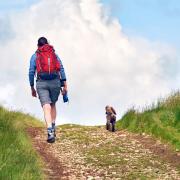
The hard work is worth the reward with this walk around Calderdale.

As always Calderdale offers you here a multitude of small, stone-walled enclosures and secretive tracks, its unmistakable architectural vernacular, its slight sense of being 'unfinished' and the constant reminder this was once a dense hive of mills and industry: spinning, carding and weaving. Like the mill workers of old, you have to work hard to gain reward here; but the views from the tops are spectacular.
From the west end of the Station Road bridge over the Rochdale Canal, climb your first test, the setted Blackwood Hall Lane. Shortly, where the Calderdale Way continues left you keep ahead up Milnergate, the Old School House on your right. At the entrance to the dwelling at the top turn left along a narrow and typically Calderdale path, with undergrowth obscuring its steps - make sure to take care. At its top go right, climb to the T-junction (Sowerby Lane), go through the unmarked gate opposite and cross the field. By the adjacent cricket pavilion you leave this field, briefly cross the corner of a second and enter a third, following a vague path which brings you to a clear track. Go left along this and round to the farm.
Here climb right, keeping this side of the fence until you reach the cottages, before which you pass via a little wooden gate. Follow the lane and take the (wrongly signed) Calderdale Way stile on the first corner. Ahead to the field corner; ignore its stile, instead climbing right, through three stiles, to reach New Lane. Go right, cross and take the stile.
Follow the wall up to Moor Bottom Lane which you follow right before going left along the setted track, soon crossing a bridleway at right angles. Then shortly, at the cairn where the path splits in three, take the left hand fork. This takes you to Weather Hill Lane. Take a left here; then after around 150 yards go through the insignificant right hand gap in the wall guarded by an old, half rotten post.
Follow the wall to reach Weather Hill Lane; turn right, passing Pitts Farm. Stoodley Pike with Withens Clough Reservoir are distantly clear on your right. Soon after, take the rising asphalted track on the left and keep along it - Water Stalls Road - also a place where for the first time the walk levels. By this point you have climbed 850 feet in 2.25 miles. This clear track becomes first earthen (at a power pole and farm), then later is joined by the Calderdale Way - follow it over 1.3 miles of heather moorland.
Arriving at a meeting-place of paths and gates, you take that on the left which seems to double back the way you've come. Soon another path joins from the right. After passing a cottage and gate you soon descend quite sharply to Kennel Lane. Turn right, and follow the lane, crossing Shaw's Clough beck on its hairpin bend. With a church steeple straight ahead, leave the lane, taking the bridleway on the left - this is Clough Bank Lane. Somewhere in the ensuing climb, pretty overgrown and much narrower at the top end, this becomes a footpath! Either way, mind your ankles.
At the top go right, pass the kennels on the right along Parkin Hall Lane. Very soon, at the triangle of roads, go right then cross to follow the track between wall and fence. Arriving at Shaw's Lane go right, then left up past the cottages. The views across to Hebden and Sowerby Bridges are stunning - make sure to stop and take them in.
Take the first stile on the right almost at once, descend close to the power pole to pass through the former gateway, then follow the wall hard round left until you reach a steep gully, the road wall and the barely visible stile at the stables. Go through their gates, follow the overgrown path ahead along the fence, then the field edge to Mirey Lane. The path across the road here takes you over three fields to the delightfully named Higham and Dob Lane.
Turn right, then turn left on to the beautifully setted bridleway about 50 yards down. From its end follow the equally attractive sidewalked field edge by Glen View cottages, with its centuries old slabs still doing a fine job of keeping boots mud-free.
At Shield Hall Lane turn right, and after a quarter mile take (with care) the overgrown stepped path down to the cottages. Turn left, then drop down the setted track to where the beck runs noisily. Turn right going with it along the final setts and, with the path now an asphalted lane, descend to the railway bridge on Stoney Lane. Take a right at the cottages over the Calder; picking up Rochdale Canal towpath, do a final left and the last half a mile home.
COMPASS POINTS
Start/finish: OS grid reference SE036250, HX2 6AE (approx. location only)
Distance: 7.5 miles/12.2km
Ascent: 1100ft/333m
Terrain: Easy/moderate
Parking: On street parking in vicinity
Refreshment: Great options including restaurants, cafes and pubs. Travel a little farther afield for Yorkshire Life's Dining Pub of the Year, The Moorcock Inn at Sowerby Bridge
Map: Ordnance Survey Explorer OL21