Terry Fletcher leads a walk in a little-explored corner of Yorkshire, near Hornsea

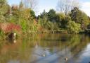
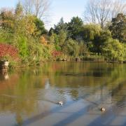
Holderness, the south east corner of Yorkshire, tucked away behind the Wolds and facing the North Sea between Bridlington and Spurn Head is often overlooked by walkers, perhaps because it is largely flat or perhaps because the footpath network is less well-developed than more popular areas but this walk makes use of the easiest of paths and visits one of our little-known natural wonders. Hornsea Mere is the largest freshwater lake in Yorkshire, covering 464 acres and two miles/3.2km long it easily dwarfs its nearest rival, the much more popular Malham Tarn at a paltry 150 acres and the even smaller Semer Water at 100 acres and only a quarter of the length.
Today the mere, pride of the seaside resort of Hornsea, is the haunt of yachtsmen and birdwatchers but it was once a magnet for Victorian tourists using the Hull and Hornsea railway. The line lasted exactly a century, closing in 1964 but is still used by tourists today as an off-road walking, cycling and horse riding route into the town.
The walk starts from the site of the former Sigglesthorne Station but don’t be fooled. The station, now a private house, is more than a couple of miles from the village whose name it carries and is actually on the outskirts of Great Hatfield, which also has a handy pub for post-walk refreshments. The stop was originally called Hatfield but the name was changed in 1874 to avoid confusion with Hatfield, near Doncaster.
DIRECTIONS
The opening section is a gentle stroll with no problems either underfoot or with navigation. It follows the old railway track north east, now part of the Trans-Pennine Trail. The clear, broad bridleway, which is shared with cyclists and horse riders crosses two minor roads before continuing for another mile or so, flanked by open fields and pastures where horses graze. It is also bordered by thick hedgerows filled with birdsong. After it passes under a red brick road bridge, the trail ends abruptly on the outskirts of Hornsea.
Here, turn left on a track which leads down through allotments to a road. Cross over and turn left along it. After a couple of hundred yards, just after the road leaves the last house, turn right onto a field path with Hornsea Mere directly ahead.
The track passes through a collection of humps and mounds, all that is left of the mediaeval village of Southorpe. Never home to more than a few dozen inhabitants, it was listed in the Domesday Book but was finally abandoned in the 17th century. It now takes some imagination to conjure it back into existence.
Sadly the shoreline of the mere, which is a popular haunt of yachtsmen, is private and so must be admired from the public footpath which carries on leftwards, parallel with the shore. After crossing a couple of fields the path becomes more enclosed by a wire fence before continuing across fields in roughly the same line, following waymarkers and a hedge.
Go through a kissing gate and then at a second kissing gate go half right across the field to a gate in the right hand corner. This is immediately followed by a wooden footbridge. Cross this and continue on the path across the field, which is left by yet another kissing gate to join a wide bridleway. Go right along this through another gate.
This brings the only really tricky bit of the walk. The right of way continues down the bridleway for a hundred yards of so to a band of trees where a public footpath sign points sharply back leftwards, directing you almost – but not quite – back across the pathless rough pasture. Evidence on the ground suggests that most people ignore this little detour and simply walk along the top edge of the field from the last gate. Either way leads to a kissing gate hidden deep in the undergrowth just to the left of a clump of trees in the top boundary of the field. Once you have located this the difficulties are over.
Go through it and take a diagonal path half right across the field making for a large metal kissing gate in the opposite hedge. Cross the next field in roughly the same line on the now better-defined path then continue round more smaller fields to the farm buildings of the hamlet of Goxhill.
At the buildings, look left for the unusual cement-rendered Church of St Giles, which is still in occasional use. From the church, carry on left down the road and at a crossroads go straight ahead until the road meets the disused railway used on the outward leg. Turn right up the trail. It is possible near the end to take a signed diversion leftwards to the Wrygarth Inn at Great Hatfield if you feel you have earned some liquid refreshment. Otherwise carry on another couple of hundred yards to the car.