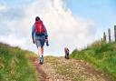
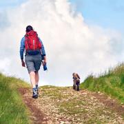
Take this route of green lanes and field paths and marvel at the dramatic views.

This walk was published in August 2013, so the details of the route may no longer be accurate, we do advise these articles should only be used as a guideline for any potential route you take and you should double check an up to date map before you set off.
The country bounded by the Three Peaks in the west of the Yorkshire Dales National Park is a maze of side valleys and ravines with secret waterfalls, hidden caves and limestone outcrops which change colour from eye-searing white to drab grey to match the skies.

This walk from the tiny village of Austwick, less well-known than neighbouring Clapham but no less charming, explores two of them with the added bonus of dramatic views of two of the Three Peaks.
Directions

Start from the centre of the village and walk towards Helwith Bridge, passing the Game Cock Inn and the village school to turn left up Townhead Lane, which climbs between attractive stone houses.
Just after the last buildings, look out for a gate with a lintel and a stile on the left, signposted to Clapham.
Cross this and climb beside the left-hand wall and after crossing two pastures the path emerge onto Thwaite Lane.
|
||||||||

Turn left along this unsurfaced track, one of the many old drove roads that criss-cross the Dales and follow it for an easy mile, with the impressive limestone cliff of Robin Proctor's Scar on your right. On dry days the tiny figures of climbers can often be seen plastered across the rock face. Carry on until the well-made track meets another green lane, the aptly-named Long Lane, signposted rightwards to Selside. Take this as it climbs across the eastern flank of Clapdale for well over a mile with views of Ingleborough across the trough of the dale. Just after passing through a gate, look over the wall to the left into the black maw of Ingleborough Cave in the valley bottom with its limestone headwall and curtain of trees. The cave is one of the area's oldest tourist attractions, having been open to the public for more than 175 years. Today its dramatic rock formations are floodlit and concrete pathways make the exploration easy.
But this walk aims for the heights rather than the depths and the lane eventually ends at a gate leading into open ground. Here climb the path heading half right, aiming for another gate in the wall above. Go through this and carry on uphill until the path starts to level out. Follow it across the fellside until it curls rightwards in front of a long, low limestone escarpment, to cross the watershed into Crummackdale.
This section coincides with the recently-opened Pennine Bridleway so there are occasional reassuring marker posts. Continue onwards with the bulk of Penyghent coming into view and with that as your guide carry on along the main track. The track passes Long Scar before eventually running beside a wall on the right with a desert of limestone pavement in a great bowl below. After following the wall for a quarter of a mile it reaches Sulber Gate at the entrance to the Ingleborough Nature Reserve.
Do not go through this but instead turn right through a narrower gate in the wall with the limestone amphitheatre of Thieves Moss at your feet. This vast expanse of limestone pavement is another of the Dales' treasures and one of the signature landscapes of the national park. It was formed over millions of years as water ate channels through the rock leaving large blocks, known locally as clints, separated by grykes which are home to rare Alpine plants.
Drop down the clear path and follow it as it parallels the escarpment for about 100 yards until a small and easily-missed cairn marks a narrower path off to the right. This weaves through the limestone, gradually becoming clearer until it comes to Beggar's Stile, a tall ladder stile through the low crag.
The path now drops through rough pasture, marked by the occasional cairn into Crummackdale, until it meets a wall, follow this rightwards to a gate and then continue down past the farm following the signs until it is possible to join Crummack Lane, another unsurfaced track leading down the valley. This is the start of another long easy section of about a mile until, not long after the lane becomes tarmac and just beyond a sharp right-hand bend a ladder stile in the wall on the left gives access to the fields.
Drop downhill to cross the stream by a footbridge and then over a stile in the wall ahead. At the top of the next field a stile in the left-hand corner gives onto a green lane. Cross straight over and carry on in the same line with a wall on your left. At the bottom of the field climb a stile to enter the grounds of a cottage and through a gate to the left of the garage and on through another garden to reach the road. This is Townhead Lane climbed at the start of the walk and is followed back to the village.
FACT FILE
Start/finish: Austwick village
Distance: 8 miles/13km
Time: 3 hours
Terrain: Green lanes and field paths. Short section of limestone pavement
Refreshments: Pub in Austwick, cafes in Clapham and Settle
Map: OS OL2 Yorkshire Dales Southern and Western