Take a drove road and enjoy classic Yorkshire Dales scenery

This walk was published in March 2019, so the details of the route may no longer be accurate, we do advise these articles should only be used as a guideline for any potential route you take and you should double check an up to date map before you set off.
Lovers of the austere grandeur of Swaledale and Ribblesdale or the softer, contours and plump villages of Wensleydale may argue as much as they like but, if visitor numbers alone are anything to go by, Wharfedale is the Queen of the Dales and Grassington its undisputed capital. Easy access from the West Yorkshire conurbations helps of course but given a half-decent forecast the village will be bustling and the shops and cafés doing brisk business.
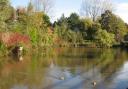
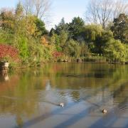
Some visitors will be wandering down to the riverside and Linton Falls, which are particularly impressive after winter rains, and sometimes also have the added entertainment of canoeists shooting the narrow gaps between the rocks, an activity not intended for the faint-hearted. The more energetic will be found wandering some of the delightful paths that follow the Wharfe both up and downstream or out onto the higher fells.
This walk takes a middle course, shunning both the waterside and the highest tops, climbing part way up the hills to an old drove road before returning via the Dales Way long distance path. It offers glimpses into the history of the valley as well as a fine perspective on the classic glaciated U-shaped upper dale.
DIRECTIONS
1. Leave the Main Square by the road at its top left hand corner and walk up to the town hall. Turn left into Chapel Street. Carry on down this until you reach Bank Lane on the right hand side and turn up this, signed to the Dales Way and Bycliffe Road. It soon deteriorates into a rough farm track and at a bend the Dales Way turns off leftwards through a gate. This will be the return route. For now stay on the main track. The tourist bustle of Grassington has already been left far behind as the track becomes an attractive green lane leading into a long pasture. At the far end pass through an ungated gap and then turn half right into the field, shadowing the right hand wall until you reach a gated stile. Go through this and then head diagonally leftwards. The path continues climbing gently but steadily over a series of pastures to a stile marked by a three-armed finger post. Here turn left following the arrow to Bare House. The view now is of classic Dales scenery of rounded grassy ridges studded by limestone knolls and craglets and a web of drystone walls under huge skies.
2. The track passes the buildings of Bare House. These days they are bare indeed, uninhabited and apparently used only for storage. It is a lonely spot, suited only for a recluse or a hermit and must have been a bleak place to live in winters past. The path continues climbing in roughly the same line to a wall where a slightly awkward gated stile gives onto a short green lane. Turn left along this. Go round a corner and almost immediately take a wooden gate on the left onto another green lane marked with a yellow footpath arrow.
3. Several rough pastures ensure with the track twisting this way and that though always heading generally northwards before it arrives at the rough vehicle track of the Bycliffe Road. Turn left down this. Soon the booster mast above Conistone comes into view ahead. The road sweeps extravagantly rightwards and for a while seems to be heading in the wrong direction but then curls back heading for the mast. As it descends it comes to an area of limestone pavement on the right which is slowly being reclaimed by scrub trees.
4. Immediately after passing this look to the left for a gate and a Dales Way sign pointing the way to Grassington. Go through the gate and follow the Dales Way, which at this point passes above the deep, narrow valley of Conistone Dib. From here onwards the track is wide and easy to follow and, as befits Yorkshire's most popular long distance trail, is amply waymarked with signs and yellow arrows. Along the way it passes a well-preserved lime kiln.
As the track nears Grassington it jinks sharply leftwards and heads down to a large group of modern farm buildings. Just before entering the farmyard take a stile in the wall to the left and cross two more small fields to arrive at the gate passed on the outward stretch. Go through this and turn right to follow the track back to Chapel Street and retrace your outward route to the start.
COMPASS POINTS
Start/finish: Grassington Square
Distance: 7 miles/12km
Ascent: 850ft/260m
Terrain: Moorland paths and green lanes
Time: 3-4 hours
Parking: Pay and display at national park centre on Hebden road
Refreshment: Pubs and cafés galore in Grassington
Map: OS OL2Yorkshire Dales Southern and Western