The train takes the strain allowing walkers to enjoy the beauty of the Ribble
Horton-in-Ribblesdale, with its legacy of quarrying, will never be the most picturesque village in the Dales but its enduring popularity is nevertheless still guaranteed thanks to its position in the heart of Three Peaks country. It sits snugly between Pen-y-ghent and Ingleborough and its caf� is the official starting point and even more welcome finish for many attempts on the 23-mile challenge circuit of all three tops.
It also lies on the route of the world-renowned Settle-Carlisle railway. The Victorian entrepreneurs and tough navvies who drove England’s highest mainline across, through and under the Pennines could never have imagined the service they would be doing walkers a century later.
Their creation leaps across the valleys on spectacular viaducts like Ribblehead and Dent and delves into long tunnels like Blea Moor, not only opening up some of the county’s finest walking to non-car owners but also allowing motorists to cut the umbilical cord to their personal metal boxes on wheels. The railway liberates them from the usual circular walks to indulge in end-to-end linear outings between stations. This one follows a delightful route from Horton to Settle, mostly on gentle riverside paths but with an exhilarating excursion onto the tops in the middle.
DirectionsFrom Horton station head down into the village. At the bridge in front of the Crown pub do not cross the river but instead double back slightly on a path on the right, signed to Cragghill Farm and follow it downstream with the Sphinx-like profile of Pen-y-ghent standing guard across the valley.
About 300 yards beyond Cragghill the path finally deserts the water and heads across the field aiming for a gate and stile in the far wall. There it enters a sunken track across more fields before eventually passing beneath the railway line to join a lane.
Cross this and take the path opposite for a couple of hundred yards before re-crossing the lane and taking the path into Helwith Bridge.Once back on the road cross the railway bridge and walk down to the main road. Turn left and after 50 yards take a rising track on the right, signed to Dale Head. This stony track soon forks and our route takes the right hand branch, now marked to Moor Head.
As the path climbs the views open out across the valley though they are dominated by three large quarries while the tops of Ingleborough and Whernside peep over the skyline.
Go through a gate at the top of the track and press on forwards until, opposite a sign to Long Lane, a stile leads through the wall on the right. This is the start of a gloriously airy promenade as the track crosses a succession of stiles with all three peaks now in view and the bulk of Lancashire’s Pendle Hill straight ahead. At the end of a relatively easy mile the path drops down through the fields towards Stainforth.
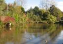
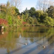
Go into the village and then turn right to the main dale road. Cross with care and turn right for 100 yards before a lane on the left allows yet another crossing of the railway and drops down a twisting, tree-lined lane to the graceful arch of Stainforth Bridge. Cross this and immediately take a gate on the left down to the riverside. This is a delightful spot for a break and the waterfalls of Stainforth Force 100 yards downstream are a well-known salmon leap in the autumn.
The path now follows the river for a mile and half before reaching a weir and footbridge. Ignore these and instead take the signed path rightwards to Stackhouse. At the road a discreetly signed bridleway almost opposite leads into the surprisingly grand hamlet of Stackhouse. After 100 yards take another lane to the left which soon curves back to the road just crossed.
Here turn right for another 100 yards to where a short flight of steps and a gate allow you to escape the road and to walk parallel to it along the field edge.
A gate in a field corner leads back onto the road. Cross over and pass through another gate where a sign points to Settle Bridge. Follow this final riverside path to the town. Turn left and the railway station is down a side road to the right just beyond the Market Square.
Fact file
Distance: 9 miles/14.5km.Height: gained: 400ft/125m.Time: Four hours (leave plenty of time if you are catching a train).Terrain: Mostly riverside paths with a brief excursion onto higher ground.Map OS: Yorkshire Dales West.Refreshments: Caf�s and pub in Horton, Stainforth and Settle.Train times from www.nationalrail.co.uk or phone 08457 48 49 50.