Enjoy the peace of a walk through Yorkshire's own mini Lake District. Terry Fletcher is your guide Photograph by Mike Kipling
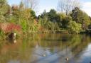
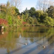
Thanks to being left out of the Yorkshire Dales National Park more than 50 years ago, Upper Nidderdale still remains one of the least visited of the major Pennine valleys. But as this walk shows it is easily the match of any of its more famous sisters and blessed with a lonely charm many of them have lost. A line of reservoirs strung along the upper valley give it a unique character in the Dales where it almost serves as a mini Lake District.
Directions
This walk starts from the village of Middlesmoor, which sits on the tip of a steep ridge overlooking the valley. Standing in the churchyard with the ground falling away below it has the feeling of standing on the prow of a vast ship forging towards the waters of Gouthwaite Reservoir far below.Leave the car park and turn right away from the village along a broad green lane which leads gently upwards along the ridge with fine views across the valley to Great and Little Whernside and the surrounding tops.
This is part of the Nidderdale Way and for the next two miles there are no navigation problems as it marches along the spine of the ridge. Eventually, as it starts to lose height Scar House Reservoir comes into view cupped in the valley below and the track snakes down to cross the dam.
Scar House was begun by Bradford Council in 1921 to slake the thirst of the expanding city and was not completed until 1936. Throughout that time a thriving village was created to house the reservoir builders and their families, complete with cinema, gymnasium, hospital, canteen and even a fish and chip shop. It was linked to the outside world by a now long-dismantled railway. All that is left to mark the passing of this community is the rectangular concrete bases of the old buildings. All, that is, except the canteen, which today serves as the village hall in Darley further down the dale.
Today there is a large car park which could be used to start the walk if that at Middlesmoor is full.
Having crossed the elaborately crenellated dam - a monument to the inter-war civic pride of a city at the height of its wealth and power - turn left up a rising track and then after 100 yards cut back rightwards along another inclined path signposted Nidderdale Way and public bridleway to Lofthouse. Continue along this as the path drops into a ravine and climbs steeply up the other side. Continue more easily onwards for about half a mile until a white painted post marks the start of a narrow path branching off to the right. Follow this past another white post and through a gate to reach a wide track curving down towards the valley floor.
There the Nidderdale Way resumes as a broad green track. Turn left and slightly uphill to pass above a plantation. The track undulates and meanders gently above the valley floor with fine views of the curving upper dale and the wooded banks of the Nidd below.
The track eventually becomes hard surfaced, providing easy walking past several isolated houses. Eventually it seems to be blocked by a farmhouse. Go through the gate and rightwards round the building and through the gardens to leave via a sign-posted gate and a track which descends the hillside. At a junction take the left hand fork and the path soon zigzags steeply down the slope via some worn steps.
At the bottom turn left along the wall following a bridleway sign. Cross a dried streambed behind the barn and pass behind the barn before weaving through the farm buildings to an easily-missed stile on the right just before a Dutch barn. Squeeze through this and cross fields to walk up to a narrow gate opening onto the road which serves the reservoirs.
Cross the road to another narrow gate with a public footpath sign and head up across the field to another stile, then head diagonally left to another gate. Go through this and up the next field, still following the footpath arrows. Continue upwards and trending slightly left until it emerges onto a farm track by an iron gate. Turn left along this and continue through several gates and passing a farm with fine views of Gouthwaite down the valley.
It finally emerges at a T junction with the green lane used on the outward leg. Turn left down this to Middlesmoor.
Start/Finish: Middlesmoor, near Pateley Bridge.
Length: 9 miles. Time: Allow five hours. Map: OS Explorer 298 Nidderdale.
Terrain: Mostly on good tracks, a couple of short steep descents and a final climb.
Refreshments: Pubs in Middlesmoor and Lofthouse, caf�s and pubs in Pateley Bridge, None on the route.