Enjoy this walk through a much loved landscape in the Yorkshire Dales National Park.
This walk was published in JUne 2011, so the details of the route may no longer be accurate, we do advise these articles should only be used as a guideline for any potential route you take and you should double check an up to date map before you set off.
Gazing across the sheep-dotted hillsides of the Dales it is hard to believe this same landscape was once roamed by much more dangerous creatures from a much warmer world. Climate change, it seems, is nothing new.
This delightful walk begins in Settle, a town now bypassed by the main road but still retaining a bustling charm thanks to its market and a lively tourist trade. It then visits one of the national park's most attractive waterfalls before taking a glimpse into the distant past, long before the dawn of recorded history.
Directions
From Settle Market Place with your back to the Naked Man Caf� pass up the left side of the Shambles building opposite and start to climb Constitution Hill. After a steep pull the road levels out. Take the right fork with a Pennine Bridleway sign pointing the way to Langcliffe. After a short fierce climb the track passes through a gate into an open field. Follow the track along the field bottom.
The path becomes briefly enclosed before another open field where the distinctive shape of Penyghent appears ahead. Take a ladder stile on the left and cross to a gate in the opposite wall contouring above a wood and drop down leftwards to Langcliffe. The village, which is mentioned in the Domesday Book, owes its fortune to milling, farming and quarrying and has some fine 17th century buildings which are well worth exploring.
Return to the church and school and take the footpath signed to Stainforth. The path slips between the houses before reaching a crossroads by Hope Hill Farm. Here turn right and follow the enclosed lane to its end and then take the signposted path rising towards the quarry top.
Go through a small gate at the top of the track and complete the final steep climb to the brow. At the top take a stone stile between two gates and cross the field towards High Winskill Farm, emerging on a farm track. Turn right along it and by the farm entrance Penyghent springs into view. Cross in front of the farm and follow the wall and faint track rightwards.
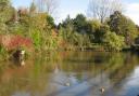
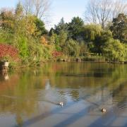
When the track seems to peter out look half left for a Pennine Bridleway signpost by the wall. Go through the gate and down the track to where a group of trees indicates the hidden location of Catrigg Force.
The falls are heard before they are seen but take care around the unfenced top, especially if the party includes children or pets.
A flight of stone steps leads down to the foot of the falls which tumble in two drops into a tree-shrouded pool in a limestone ravine. They are a delight to visit and make a perfect picnic spot.
Leave the falls by the same track by which you arrived and climb back up the field to the gate with the Pennine Bridleway sign. Go through the gate and follow this broad track out to the Malham Moor road. Turn right and follow the road through the Winskill Stones nature reserve which is dedicated to the late TV gardener Geoff Hamilton, who led the campaign to save the stones from being dug up for rockeries.
At a cattle grid a seductive green track climbs leftwards. Go up this and after about 100 yards take the left hand fork which climbs to a stile giving onto a broad track. Up and leftwards is the entrance to Jubilee Cave but our route lies rightwards downhill.
When it reaches a gate do not go through but take the path on the left through a pedestrian gate and contour along the foot of the scar on a path signed to Victoria Cave. As you walk along the wallside keep an eye out for a muddy path which climbs leftwards to the cave. This is an astonishing record of the history of this landscape and finds unearthed here go back 130,000 years to an age when the land here was warm enough to support the hippopotamus and elephants whose bones have been found inside. After the last Ice Age 10,000 years ago it was occupied by brown bear and reindeer as well as the men who hunted them.
In 1837 the cave was rediscovered by accident when a dog was sent in. Since then hundreds of tons of accumulated earth and debris have been dug out, creating the present large cavern and revealing 130,000 years of history which had been buried and preserved in clay.
Having explored the cave, continue down the valley across a wide pasture and a rocky slope. Keep an eye out for a gate in the wall on the right. Go through this and follow the stony path down as it contours rightwards below Attermire Scar.
The now-broader path climbs the hill ahead until it crests the brow and Settle comes abruptly into view. Carry on downhill until, after a final sharp descent, it rejoins the outward route. Turn left down into Settle and some well-earned refreshment.
Fact file
Start/Finish: Settle Market Place
Length: 7 miles/11kms
Height gain: 700ft/215m
Time: 4 hours
Map: OS Explorer OL2 Yorkshire Dales South and West
Terrain: Mainly Green Lanes, farm tracks and field paths, two steep climbs
Refreshments: Settle has an abundance of pubs and caf�s