Photographer Graham Dunn continues his visual journey of the Peak District National Park

Following on from the April 2017 issue of Derbyshire Life, where we enjoyed scenes from the Eastern Peak, we continue our visual tour of the Peak District National Park and now journey on to the Northern Peak. As with the Eastern Peak, we remain in Dark Peak territory, though this time the landscape is dominated by vast gritstone plateaus, reservoir-filled valleys and the delightful Hope Valley in the south. The terrain is more challenging here and in places requires more effort and determination to access, but exertion is seldom wasted and the more adventurous are rewarded with an abundance of stunning vistas. The Northern Peak also boasts the highest point in the Peak District – an area on Kinder Scout which stands at 636m above sea level. Again, the challenge of representing such a stunning area within the confines of a short article has proved tricky and though I have had to exclude the likes of, amongst others, Winnats Pass and the Woodlands Valley, I hope the following imagery will provide you with a flavour of what awaits should you decide to visit...

1 Commencing in the north, we first visit Black Hill, a gritstone plateau that lies to the north of the Longdendale Valley. Here we see a flag-paved section of the Pennine Way winding its way towards the summit trig point, whilst en route to its end point just over the Scottish border.

2 Moving south and the next significant hill, again a gritstone plateau, is Bleaklow. These plateaus have relatively impermeable bases which makes this ideal terrain for the formation of blanket bog. Whilst it can make for treacherous crossings, healthy blanket bog is vital for its abilities to store carbon and keep it from entering the atmosphere.

3 Sandwiched between Bleaklow and Kinder Scout is a beautiful feature called Doctor’s Gate. The site of an old Roman Road, it is thought to have been named after a 16th century doctor who used this route to visit his patients from his base in Glossop. Here it is shown under stunning sunset skies – the vivid colouration provided by atmospheric ash from the Icelandic volcanic eruptions in 2010.

4 At 636m, Kinder Scout boasts the highest point in the Peak District National Park. Kinder Low (pictured) sits just below this at 633m and offers fine views over the distant and mist-filled Edale and Hope Valleys. Another gritstone plateau, its edges are littered with fascinatingly-shaped and interestingly-named rocky tors.

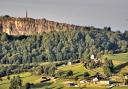
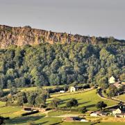
5 Directly south from Kinder Scout lies Mam Tor, the site of an impressive Iron Age hill fort, which sits proudly at the end of the Hope Valley and provides truly panoramic views. The Great Ridge (pictured) lies between the Edale and Hope valleys and runs from Mam Tor to Lose Hill, passing over Hollins Cross and Back Tor on the way.
 and its neighbour Win Hill (distant left)")
6 At the far end of the Great Ridge we come to Lose Hill (right) and its neighbour Win Hill (distant left). These iconic peaks are thought to have been named after a particularly bloody 7th century Saxon battle. With an army based on each of the two hills, a grisly encounter ensued in the valley between. The camp of the victors became known as Win Hill and that of the losers, Lose Hill!

7 Back-tracking north-west slightly, we next arrive at Fairbrook. From here, water flows down into the River Ashop and then east into Ladybower Reservoir. After heavy rainfall, when the brook is in full flow, a number of stunning waterfalls come to life. The northern edges of Kinder Scout can be seen in the distance.

8 Ladybower is the southernmost of the three Upper Derwent Valley reservoirs and is the largest body of water in the Peak District. Its construction was completed in the 1940s, requiring the flooding of the villages of Derwent and Ashopton.

9 North from Ladybower sits Derwent Reservoir. Flanked by two dramatic dams, it is probably best known for its role as a training ground for the RAF’s 617 Dambusters Squadron in the Second World War. Lancaster Bombers can occasionally be seen re-enacting their training run as part of memorial flypasts – the neighbouring Derwent Edge provides a memorable vantage point on such occasions.

10 And finally, we conclude our tour on a lesser known hill called Ox Hey, which stands over the northern tip of Howden Reservoir – the reservoir itself can be seen in the distance reflecting the colourful dawn skies.
In the next instalment, we will take a break from Dark Peak terrain and explore the wonderfully different landscape of the White Peak.
Graham is a full-time photographer specialising in fine-art landscapes, interiors and portraits. He also enjoys sharing his passion with others, especially those who wish to take their photography to the next level, and offers workshops on a 1-2-1 or small group basis. For more information and to see more of his work please visit his website at www.grahamdunn.co.uk