Gary Wallis continues his alphabetical tour of Derbyshire and the Peak District with sites beginning with I and J

Ilam
Located in the Staffordshire Peak District approximately four miles north-west of Ashbourne, Ilam lies on the River Manifold. It is now almost a quarter of a mile from its original position, as it was re-located in the 1820s by Jesse Watts Russell when he rebuilt Ilam Hall. The cottages in the hamlet are very attractive and in keeping with Jesse’s direction that they should be designed in an ‘Alpine style’. The centrepiece of the village is the Mary Watts Russell Memorial Cross which was erected to commemorate Jesse’s wife. It is Grade II listed and was the subject of an award-winning restoration project in 2011. The village church, which retains its original position close to Ilam Hall, dates back to Saxon times when records show the area was first settled. In 1004 a group of monks from the abbey at Burton upon Trent established a monastery here. The house of worship we see today, the Church of the Holy Cross, is a result of 17th and 19th century restorations. It contains a magnificent Saxon font and the tomb of St Bertram, a Saxon prince of Mercia and hermit. He travelled to Ireland to marry an Irish princess and on the way back to Mercia she had a child. While they rested in the forest nearby Bertram went to seek food and when he returned wolves had killed them.

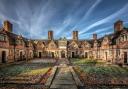
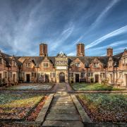
Ilam Hall
Built by Jesse Watts Russell the present – second – Ilam Hall was constructed between 1821 to 1827. The first hall was built by the Port family in the 16th century but it was demolished in order to make way for its successor. However, the hall that we are left with today only accounts for a quarter of the original building. This was sold for demolition in the 1930s and three-quarters of it had been reduced to rubble when Sir Robert McDougall stepped in and bought the property. Shortly afterwards, in 1934, he donated the hall, which is now a Youth Hostel, to the National Trust.

Ilam Rock
Situated roughly half way along Dovedale between Thorpe Cloud and Milldale this spectacular limestone pinnacle is just over 80ft (25m) high. There are eleven recognised climbing routes on the needle including ‘The Gladiator’, ‘Eye of the Tiger’ and ‘Chunky Punky’.

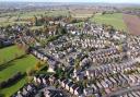
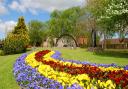
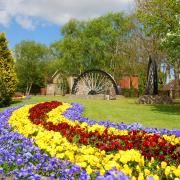
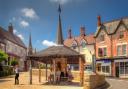
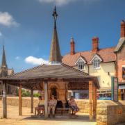
Ilkeston
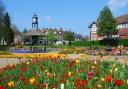
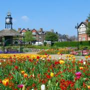
Known locally as ‘Ilson’ in the distinct local dialect recognised as East Midlands English, the town dates back to the 6th century. It is thought that it was named after an Anglian chieftain, believed to be its founder, who was known as Elch or Elcha. In the Domesday Book of 1086 the town is referred to as Tilchestune. Once famous for its spa, Ilkeston Bath was built in 1831 and attracted visitors from around the country. However the baths were closed in 1900 when the waters became contaminated by mining activities in the area. Ilkeston is the site of an annual fair which pre-dates Nottingham’s more famous Goose Fair. The fair, traditionally held two weeks after the Goose Fair, celebrated its 761st birthday in 2013. Ilkeston was once a centre for coal mining, iron works and textile and lace-making, however, these industries have now declined and disappeared. Victoria Park, pictured here, was opened in 1902 by the Duke of Rutland and is a popular recreation area that includes a bowling green.

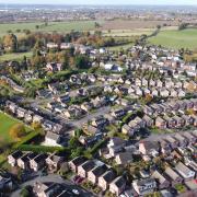
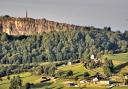
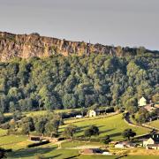
Intake Dale, Bradwell
Just to the south-west of Bradwell the view from above this short and shallow dale reveals an impressive panorama eastwards to the sweeping curve of Bradwell Edge. The dry stone walls that criss-cross the fields blend in with the limestone outcrops illustrating perfectly why this area is known as the White Peak.

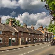
Ironville
Situated two miles east of Ripley the original village was built by the Butterley Company for their workers between 1834 and 1860. At the time the project received much acclaim as an example of corporate care and responsibility by this once large engineering company. The village had two schools, a church, library and swimming pool, as well as its own gas and water works. The gardens of the houses were large for the era and the hamlet was in a rural setting a good distance (two miles) from the ironworks. Much of the old village was demolished in the late 20th century when the Butterley Company fell into decline. The company finally closed in 2009, over 200 years since its foundation in 1790.

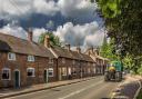
Idridgehay
First mentioned in the Duffield Rolls of 1230 the village lies in the Ecclesbourne Valley about five miles south of Wirksworth. The name of the village is derived from ‘Eadric’s Enclosure’ and over half a century ago the hamlet was a thriving agricultural area with more than 30 working farms. Nowadays Iridgehay is mainly a residential village. The church of St James the Great was designed by Henry Isaac Stevens of Derby and consecrated in 1845. The famous Victorian landscape artist George Turner is buried in the graveyard. The church narrowly avoided destruction in 1942 when a German plane dropped a land-mine which almost demolished the vicarage.

Jacob’s Ladder
This famous footpath is situated on Kinder Scout’s southern slopes and runs from the old Packhorse Bridge, known as Yongate and located about 1 mile west of Upper Booth, to Edale Cross at a height of 1775 ft (541m). Over recent years the official Pennine Way route to Kinder Downfall has been diverted along Jacob’s Ladder in order to reduce erosion of the plateau. The original steps of this pathway were cut into the hillside during the 17th century by Jacob Marshall, a resident of Edale Head House.

Jenkin Chapel
A mile to the west of the Derbyshire border and situated in the Cheshire Peak District this unusual and charming house of worship is located about a mile to the west of the Goyt Valley. Built by local people from the gritstone native to the area, the chapel was completed in 1733. Originally dedicated to St John the Baptist it was reassigned to St John the Evangelist upon its official consecration in 1894. The chapel is particularly striking when illuminated by a setting sun as illustrated in this photograph.
For more of Gary’s images of the Peak District and around the country visit www.insightphotographic.com