Three short walks from Cheshire town centres that – with judicious timing – could make a virtue of the short daylight hours by combining a spot of shopping, a bite to eat.

Winsford
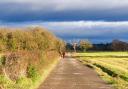
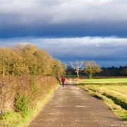
This walk starts at the Red Lion pub on the roundabout where the A54 crosses the Weaver at Town Bridge. You can walk down to the start point from Winsford town centre via the Town Park, or there is parking available at the Rangers Office off Weaver Valley Road near the Wharton Park Stonehouse (in which case, join the route near step 4).
Winsford is a relatively new town: the original settlements were Wharton and Over, on opposite banks of the Weaver, and Winsford referred just to the restricted area around the river crossing. Many of the riverside buildings were affected by subsidence, so the centre of the town effectively migrated uphill. Salt produced in Winsford included both the white table variety, evaporated in indoor brine pans, and coarse salt for fish, produced in open-air pans. Huge piles of pinkish rock salt, now destined for our roads rather than our fish, can still be seen across the Weaver from this walk. There was even a significant ship-building industry here, supplying the means to transport salt down the Weaver to the ports of Liverpool and Manchester.
The visual impact of industry has been softened by time, however – our route here includes a pleasantly peaceful stretch alongside the River Weaver on the Weaver Parkway Trail, and paths through former spoil now reclaimed to form an attractively wooded green space enhanced by interpretative boards explaining the area’s history.
Compass Points
Area of walk: Winsford
Start point: Red Lion, Winsford CW7 3AA
Distance: 1½ miles
Time to allow: 1 hour
Map: OS Explorer 267 Northwich & Delamere Forest
Refreshments: Red Lion theredlionwinsford.pub 01606 591818
Practicalities: A squeeze-stile, some steps and potentially muddy ground would make this walk a difficult proposition with a buggy or wheelchair.

The Walk
1. From the rear left-hand corner of the Red Lion car park, join the riverside path. Continue beyond a kissing gate.
2. When the surfaced path swings away from the river, stay on the narrower path ahead, passing an old wharf inlet and continuing alongside the Weaver. This path skirts a mineral works on your right, then climbs the bank up shallow steps as it leaves the river.
3. At a junction of paths, turn sharp right. After a stretch alongside the security fence of a parking compound, the path drops to a kissing gate onto the service road to the mineral works. Cross straight over through the kissing gate opposite.
4. Follow the path ahead through the trees, then follow the path to the right of a grassy area. After another wooded interlude, continue as the path winds through a second open area.
5. At a fork, take the lower, right-hand, path, which leads gradually down shallow steps back to the Red Lion.

Congleton
This walk takes in many of Congleton’s architectural highlights and two of its finest open spaces.
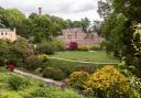
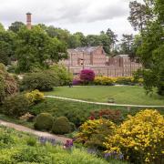
Congleton Park opened in 1871, a relatively early date for a civic park. Edward Kemp, who had worked with Joseph Paxton at Chatsworth House and then at Birkenhead Park, the first publicly funded civic park in the world, was its eminent designer. Paxton and Kemp’s work inspired visiting American landscape architects to create Central Park back home in New York. Here in humble Congleton, Kemp ably exploited the site’s natural attractions: the curving River Dane and the steep bank of Town Wood, within which Kemp constructed a network of winding paths, sampled on this route. Relics of the town’s old market cross, demolished as an obstruction to traffic in 1772, were tracked down and reassembled in Lawton Street Gardens in 1902 and later moved to the formal gardens in the park. The Jubilee Pavilion, overlooking the gardens, was opened in 1887 to celebrate Queen Victoria’s Golden Jubilee. The parents of director Lisa Whitehurst, a Congleton girl, were married there, which must have given their daughter a strong sense of purpose when she approached the council a decade or so ago to reopen it as Stock @ the Pavilion, an airy and quirkily decorated community café and bar.
Smaller and less well-known than Congleton Park is the Physic Garden. Set on a sloping site between Canal Street and Lawton Street, not far from the parish church, it contains a Georgian bath house and elegant neoclassical garden shelter, both built around 1820. These had become disused and derelict and were threatened with demolition until rescued and restored by Congleton Building Preservation Trust in the 2000s. The garden is open at all times, but the interior of the bathhouse, with its spring-fed plunge pool, is only viewable rarely, such as on Heritage Open Days in September.
The bathhouse and garden shelter are Grade II listed. Nearby, the secretive walled alleyway between the church and Canal Street, paved with granite setts and known as Cockshuts, constitutes one of the town’s more unusual listed buildings. A cockshut, or cockshoot, was an area where nets were stretched to catch woodcock.
Compass Points
Area of walk: Congleton town centre
Start point: Congleton Town Hall CW12 1BN
Distance: 2½ miles
Time to allow: 1–2 hours
Map: OS Explorer 268 Wilmslow, Macclesfield & Congleton
Refreshments: Stock @ the Pavilion Café stockpavilion.co.uk 07923 371126
Practicalities: There are play areas and toilet facilities in Congleton Park. Cobbled paths and steps mean this is a difficult route for buggies, though it could be done if you leave out the Physic Garden loop and take a lower path in the Park. The map may suggest other obvious shortcuts. Stock @ the Pavilion is open Wednesday–Sunday, 10am–4pm.

The Walk
1. Cross into Albert Place, opposite the Town Hall, then turn right into Chapel Street and walk up to the parish church. Turn left into the churchyard and exit ahead into Cockshuts, the cobbled alleyway on the far side. Turn left and follow the narrow pathway right, past a stone bollard and up the hill. On emerging at the far end, turn left out to Canal Street.
2. Cross and turn right along the pavement. Opposite the Vale Club, turn left through a gate in the wall and follow a path left of the houses, up a couple of flights of steps. Turn left into Lowe Avenue at the top. Bear left into Wellbank Court, then right onto a tarmacked path in front f the brick bathhouse. This path bends left past a bollard and then left again, passing the entrance to the Physic Garden. You can walk through the garden and exit lower down, or just continue down the surfaced path. Turn left in front of the brick building at the bottom to Cole Hill Bank, then bear right down to Lawton Street. Turn right then immediately left into Bank Street.
3. At the bottom of Bank Street, cross the main road at the lights and turn left along the pavement. Opposite the police station, turn right down steps, signposted to Congleton Park. Walk down Park Road, past the paddling pool, and follow the road round to the right. Turn left over the River Dane into Congleton Park.
4. Turn right along the riverside path. After passing a second bridge over the Dane, continue past a bowling green.
5. At the end of the park, go through a gate on the right and turn immediately left, onto an initially indistinct path up the bank next to the fence. After some steps, the path swings left along the contour. Continue in similar vein along the Woodland Walk, passing the foot of a path leading off to the right up steps. When the path meets another path up the slope, turn right up the steps. Keep left at the top of the slope and walk through a grassed area with houses to the right.
6. At the end, go past a gate and turn immediately left, down a surfaced path with a garden wall to the right. Drop down a long flight of steps to the end of Hill Fields. Walk down the street to the main road.
7. Turn immediately left into Mill Green. At the end of the houses, re-enter Congleton Park. Beyond the public toilets, turn right past the Stock café and cross the bridge over the Dane again. Turn right and follow a combined walk/cycleway past a weir to emerge by a roundabout.
8. Cross with care into Mill Street and walk up the road; at a junction, carry on up the hill. Pass the Bulls Head and Counting House pubs and continue up to the Lion and Swan.
9. Turn left and left again into Little Street, and walk down to Bridge Street. Turn right along the pedestrianised street to the junction with Market Street. Cross into Lawton Street and continue ahead to the Town Hall.

Nantwich
From Nantwich’s magnificent parish church and half-timbered town centre, we proceed down to the River Weaver. Mill Island was the site of a medieval watermill. Paths lead from here to Nantwich Lake, a small, briny lake frequented by swans, ducks and geese. The return follows the river back to the town centre.
Near the entrance to Mill Island is a large boulder on the pavement. An adjacent plaque reveals that this shapely lump of granite, discovered during the construction of the Nantwich bypass, was carried to South Cheshire all the way from Dumfriesshire by an ice sheet during the Ice Age.
Later in the walk, the path passes the Airman’s Grave. This dignified but affecting memorial records the heroic sacrifice of Lieutenant Arthur Leslie Brown, a 23-year-old pilot from Long Island, New York, whose stricken Thunderbolt fighter plane crashed in January 1944 during high-altitude training in preparation for D-Day. The plane hit the ground so hard that the fuselage, and Brown’s body, were buried too deeply to be recovered. Local farmer Philip George, on whose land the crash took place, was determined to create the memorial. He had earlier lost his own son, a Spitfire pilot, during the Battle of Britain.
Compass Points
Area of walk: Nantwich
Start point: Nantwich Parish Church CW5 5RQ
Distance: 2 miles
Time to allow: 1–1½ hours
Map: OS Explorer 257: Crewe & Nantwich
Refreshments: Artisan Café fruititionuk.co.uk 01270 620680
Practicalities: level and surfaced throughout, this walk is suitable for buggies and wheelchairs. Dogs should be kept on leads around the lake.

The Walk
1. From the west door of the church, walk down Church Walk to the High Street. Turn left then right into Mill Street, passing between the Artisan Café and Wickstead Arms. Go straight on past the ends of Barker Street (left) and Bowers Row (right) to the main road.
2. Cross at the lights and turn left, past the glacial boulder on the pavement. Turn right onto Mill Island, and take the path diagonally left across the grass. Keep ahead past a bench and cross a footbridge with houses ahead of you. Turn left along the tarmac path, with the weir stream on your left, and pass a playing field on your right.
3. At the next footbridge, recross the river and turn right. Pass under the railway bridge, and turn immediately left, away from the river. This path passes the Airman’s Memorial before reaching a car park next to Shrewbridge Road. At the end of the car park, turn right, parallel to the road.
4. This path leads to another car park at the end of Nantwich Lake. Cross the car park and take the path to the left of the lake. At the top of the lake, bear right and cross a footbridge over the inlet.
5. Follow the path to your right and walk back between the lake and river. At the end of the lake, stay on the riverside path. A winding channel runs to your right, which you eventually cross via a footbridge; again, keep to the path alongside the main channel of the river.
6. Pass under the railway once more and retrace your steps to a further footbridge, where you return to the western bank of the river and turn right, still retracing your steps but now with the river on your right-hand side.
7. At a path junction near some houses, take the right-hand path, sticking close to the riverbank. This path crosses a weir back onto Mill Island. Stay alongside the river until you reach the site of the mill, where you first crossed the river.
8. Turn right to the main road, cross at the lights and retrace your steps up Mill Street back to the town centre.