This walk isn’t as good as it could be, and that makes me sad. The last mile follows a busy B-road, for which I apologise in advance. What’s galling is that nearly half of that road walking could be eliminated using ‘Church Minshull FP4’, an interesting little public footpath that passes a listed farmhouse then drops down through a bluebell wood, follows the River Weaver and rejoins the B5074 nearer the village. It could and should be a delightful shortcut. But a long-running rights-of-way dispute means the path is rarely walked and has been neglected to the point of becoming dangerous.

The most obvious line (presumably the section in dispute) is blocked by barbed wire, the steep path down through the trees is obscure and slippery, a boardwalk over a side-stream is decaying and treacherous, and the stretch above the near-vertical drop into the swirling waters of the Weaver is unfenced and obstructed by fallen trees. So I can’t recommend it; indeed, I strongly discourage anyone from attempting it.
A sheet available from the Badger Inn describes a similar circuit to this that avoids both FP4 and the B5074 at the expense of extra miles, but I’ve compromised on distance here and taken the direct route back along the road.

I don’t know the rights and wrongs of the dispute and I’m prepared to believe the rights-of-way officers at Cheshire East are doing their beleaguered and underfunded best, but there seems to have been a stalemate over this path for at least the six years since I first walked it and queried the issues with them, and the path itself has done nothing but deteriorate in the meantime. This sort of experience is too common on Cheshire’s footpaths and, frankly, it's dispiriting.
On the bright side, there’s plenty to compensate on the rest of the route. The Badger Inn offers fine ales, good food and attentive service plus a comfortable panelled interior and a flower-filled suntrap of a garden beneath the mellow Georgian brick of the church tower. Church Minshull village is chock-full of attractive half-timbered houses clustered around the pub and church: Church Farmhouse in particular, with its glorious stilted porch and close panelling, is almost ludicrously photogenic, and Mill House on the return route is Grade II* listed, though it hides its black-and-white glories modestly behind a hedge.
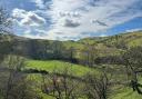
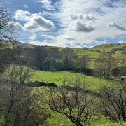
The path from village to canal climbs prettily through woodland and offers memorable views over the valley back to the church tower. The Weaver, here in its midlife prime, winds its stately way through the fields, adding landscape interest and wildlife value throughout. And the Shropshire Union Canal towpath offers carefree, uncomplicated walking through pleasant scenery. If only the same could be said for footpath 4…

1. From the front of the pub, turn left past the church. Go straight on at the roundabout and cross the bridge over the River Weaver. At a sign reading ‘Woodmeadow’, turn right and walk past the cottage of the same name into riverside fields. After a brief encounter with the River Weaver the path enters the trees and winds pleasantly via a couple of footbridges towards the canal. This is what footpath 4 could be!

2. The path emerges into the open as it approaches a canal bridge and there are satisfying views westwards over the village to the Peckforton hills and Beeston Castle. Just before the bridge, climb a stile on the left and join the canal, turning left along the towpath. After 400m you pass under Cross Lane at bridge 14. Continue along the towpath past Minshull Wharf, a former canal warehouse and cottage with exotic gables that has been attributed to Thomas Telford. Continue along the towpath for a mile and a half, ticking off bridges 15, 16 and 18 as you go (bridge 17 is missing but you can still discern its former location). Shortly after bridge 18 you pass a brick stable that once housed the horses used to pull the narrowboats, now converted to residential use.

3. At bridge 19, duck under the arch then immediately climb the steep bank left to a hand-gate at the end of the parapet. Do not cross the bridge, but turn right and head over the field diagonally, passing to the right of a couple of trees. As you approach the far side, a stile comes into view next to a gate in the hedge. Cut the corner of the next field to a metal hand-gate by a cattle trough and continue in the same direction, gradually approaching the trees on your left. This is Boundary Wood; the River Weaver at its foot marks the parish boundary and also that between Cheshire East and West. At the far end of the field, climb a stile tucked away in a corner and continue along the top of the wood. Descend past another stile to the river and follow it for a short distance to a concrete footbridge, via which you re-enter Cheshire East.
4. Cross to a gate at the bottom of a hedged farm track and follow it as it curves up out of the valley. Above the zig-zag, the track becomes metalled and continues past Lea Green Villa Farm. Reluctantly, ignore the fingerpost at the end of footpath 4 by the entrance to Lea Green Hall, continuing along the lane past a mobile home park to the B5074.
5. Turn left and follow the road with care for a mile back to Church Minshull, mercifully along a pavement for the last third as you pass the quaint pepperpot tower of the former school. At the roundabout, turn right past the church back to the Badger.

The Badger Inn
Housed in a listed 18th-century building next to the church, the Badger Inn has a classic position at the heart of its community. It was originally the Brook Arms, named for the lords of the manor, and their punning emblem of a ‘brock’ lies behind the current name of the pub. On chilly days the cosy open fires will probably be your target, but in warmer weather the pleasant beer garden, dominated by the adjacent tower of St Bartholomew’s Church, may tempt you outside.
The pub has a good reputation for its mainly British menu, from pub classics such as haddock and chips, steaks and burgers, to gourmet dishes with grander pretensions including their fresh linguine with woodland game ragu, wild mushroom and black truffle duxelle and shaved parmesan. Vegans and vegetarians are amply catered for, and walkers in search of a lighter bite might choose one of the salads, or pick from the list of sandwiches (served 12 till 5).
The menu is seasonal and changes at least four times a year. Draft beers include resident Badger Best and Plum Porter, plus two guests. Although Cask Marque-accredited, the pub prides itself on a wide variety of alcohol-free offerings, including two gins, Guinness, a cider and a lager.
Dogs are welcomed in the bars and garden, and there is ample parking for patrons. Five en-suite guest rooms are available, including a luxury king suite. The pub is open seven days a week, from 11am.

Compass Points
Area of walk: Church Minshull
Start point: Badger Inn CW5 6DY
Distance: 5¼ miles/8.3 km
Time to allow: 2–3 hours
Map: OS Explorer 267: Northwich & Delamere Forest
Refreshments: Badger Inn badgerinn.co.uk
Practicalities: One mile of busy road walking. Field paths may be muddy after rain. Several stiles.