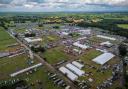
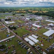
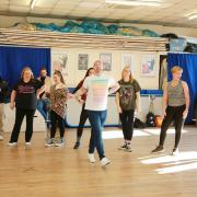
It’s an unlikely spot to find a team of world champions, but they breed them hardy in the mills and farms around the little village of Bosley, south of Macclesfield. Formed in 1947 by young farmer Alex Brown, Bosley’s tug-of-war team was a founder member of the Tug of War Association (TOWA) and quickly became a force on the national stage, winning the national title for 20 years on the trot between 1958 and 1978. European success followed, the club claiming 11 European titles for England and they went on to even greater heights, becoming world champions in 1975 and 1976. So dominant were they in the 1970s they even donated cups to be awarded to the runners-up.
The team, the only TOWA-affiliated club in Cheshire, continues to train and compete to this day on the indoor and outdoor tug-of-war circuit. In 2022 two of the club’s under-23 ladies team and one of their junior men won bronze medals at the world open club championships, the two ladies going on to win silver for England in the international under-23 event, and they are current national indoor champions. An inscribed stone at the end of Lakeside, passed on this walk, records their world-beating achievements.  David Dunford")
If you’d like to see the sport in action, the club can be found training on Tuesday and Thursday evenings at their training facility in Bosley – new members are always welcome. You can find more info about the history of the club on its Facebook and Instagram pages (@bosleytugofwar).
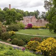
A pull round Bosley Reservoir is a rather less energetic undertaking. The reservoir was constructed to supply water to the Macclesfield Canal and is supplied by feeders – technically, ‘lades’ – from streams running off the hills to the east. The reason for its construction, overseen by Thomas Telford, was to keep the famous Bosley flight of locks in water; the nearby River Dane might seem a more obvious source, but its waters were already in use by the Caldon Canal. The reservoir originally covered 86 acres and held 410 million gallons of water, but its capacity is somewhat reduced nowadays. The reservoir is popular with fishermen and birdwatchers – don’t forget your binoculars.
The stone tower of St Mary’s Church dates from around 1500, but the nave was rebuilt in Georgian brick in 1777. A chancel was added in the 19th century, and in recent years an extension with toilet facilities has been built. The building is Grade II* listed, and a sundial in the churchyard is separately listed at Grade II.
 David Dunford")
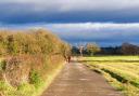
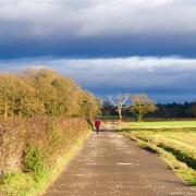
1. From the Harrington Arms, cross the road and turn left along the A523, away from the village. Very shortly, turn right into Lakeside, a residential road, taking a moment to read the memorial stone to Bosley’s all-conquering tug-of-war team. When the road divides, go straight on, through a playground. Exit via the gate at the far end onto the permissive reservoir path.
2. Turn left and follow the wide, grassy path. If you want to extend your walk slightly, a fishermen’s path on the right leads through the woodland (which may be wet underfoot) and then circumnavigates a former island with good views over the water. Otherwise, stick to the main path, which, after passing some buildings and mobile homes on your left, bends to the right. The thick hedges and scrub here are good for small birds. The path curves left towards the swampy head of the reservoir and eventually reaches a stile into Fold Lane. Turn right to the junction with the A54.
3. Turn right and follow the main road with care, ignoring a no-through road off to the left. After a further 220 metres the A54 starts to climb and, mercifully, a stile over the crash barrier on the right takes you back off-road, onto a public footpath that resumes the reservoir circuit.
4. Turn left and follow the path above the wooded reservoir shore, with the remains of a feeder channel on your left. There are occasional views over the water to Bosley Cloud, something of a constant companion on this route. The path curves round an inlet and eventually passes a weir to reach a quiet back lane via a kissing gate.
5. Turn right, then almost immediately right again over a stile into a fishermen’s car park. The path bears left through a gate with a stile and resumes its circumnavigation of the reservoir, again with an old feeder channel as a companion. As you approach the dam, you rejoin the road briefly to cross a bridge.
6. Turn right through a gated step in the wall and follow the path along the top of the dam. At the far end, you have a choice: you can either continue along the obvious permitted path back to the children’s playground where you joined it, or cross the fields for a stroll through Bosley village. For the latter alternative, drop off left down a flight of steps to the foot of the dam. Go through a kissing gate and then climb a stile by a gate into a field. Cross the field diagonally, aiming slightly to the right of the distant Cloud, to a gate on the far side. On the other side of the hedge, turn right towards some distant farm buildings. As you approach the end of the field, head slightly left into a dip within which is a concealed kissing gate. Climb the bank beyond it and bear left to the main road.
7. Cross carefully and turn right along the pavement. The road leads through Bosley village, passing the church, the former Queens Arms and the primary school on your way back to the Harrington Arms.
 David Dunford")
The Harrington Arms
Sadly, Bosley lost one of its two pubs in January 2020 when the Queens Arms closed. Fortunately, the Harrington Arms, at the other end of the village, is still going strong, billing itself as a ‘community pub’.
The pub’s name, like that of its namesake in Gawsworth, commemorates the Stanhope family, local landowners and holders of the earldom of Harrington. The family donated the land on which Bosley primary school was built in 1858, but sold their Bosley and Gawsworth estates piecemeal in the 1920s (and the family seat of Elvaston Castle, Derbyshire, in the 1960s). Until 1987 the Harrington Arms was owned by a Mr Yates, one of the brothers who founded the eponymous Wine Lodge chain; he also owned the fishing rights on an island (now permanently joined to the shore) in Bosley Reservoir. These days, the pub operates under the familiar banner of Robinsons Brewery.
Housed in a substantial red-brick building, there is a large beer garden with a play area and ample parking, though non-patrons should use the layby opposite. Dogs are welcome in designated areas. Recent comments on review sites commend the welcoming log fire, Sunday lunches, good value and friendly staff.
Please note the pub is closed on Mondays and Tuesdays.

COMPASS POINTS
Area of walk: Bosley near Macclesfield
Start point: Harrington Arms SK11 0PH
Distance: 3¼ miles/5.1 km
Time to allow: 2 hours
Map: OS Explorer 268: Wilmslow, Macclesfield & Congleton
Refreshments: Harrington Arms robinsonsbrewery.com/pubs/harrington-arms-bosley/ 01260 223113 (closed Mondays and Tuesdays)
Practicalities: Free parking opposite Harrington Arms. Paths may be muddy, and there are a couple of stiles (the majority avoidable). One stretch along the narrow A54. Bosley is on the two-hourly 109 bus route from Macclesfield to Leek.