Mysterious carvings and Merseyside views on a great family walk
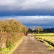
Maybe it was the weather – a typical spring mixture of squally showers and warm sunshine that left the wet ground steaming – or perhaps it was the views over the Liverpool waterfront and the liberation from deskwork that brought the Beatles’ song to mind: 'One day you’ll look/to see I’ve gone/for tomorrow may rain/so I’ll follow the sun.' As earworms go, Paul McCartney’s effortless classic isn’t a bad one to have, but it accompanied me all the way round this easy circuit of Bidston Hill above Birkenhead. And it seemed particularly apposite when I came upon the unearthly engraving of Sunna, a Viking sun goddess, carved into the soft sandstone of the hilltop, her arms outstretched and an unmistakable sunburst symbol at her feet.
There are several of these ancient figures etched into the flat bedrock of Bidston Hill. Some are difficult to find and all are hard to date, but they are usually ascribed to the Irish Norse of the ninth century. The sun goddess has a lunar companion, though she is less easily found in the undergrowth and best left undisturbed and there is also a horse’s head and a series of human figures known as the Mummers, though the last, carved into a rock step near the observatory, may be more recent.
I almost hesitate to draw attention to them as they are so vulnerable to erosion and vandalism and visitors are sincerely urged not to tread on them nor, god forbid, attempt to clean or otherwise ‘enhance’ them.
The prominent location of the hill, and its wide views over the Mersey and Dee estuaries, must have attracted the carvers of old. They certainly determined the siting of later monuments, namely the windmill, observatory and lighthouse. The windmill dates from around 1800 and was built to replace an earlier structure that was lost to fire, reputedly ignited by friction in the frantically clattering wooden mechanism during a ferocious gale. The Bidston Observatory of 1866 was used to calculate times and tides (including for the D-Day landings) and it was from here that the One O’Clock Gun on the Liverpool dockside was triggered remotely, a tradition that ended only in 1969. The association with the docks is of long standing: the hill was also the site of a line of signalling station used to notify Liverpool merchants of the imminent arrivals of their tall-masted sailing ships and some of the 18th-century flagpole sockets survive to this day.
Bidston Lighthouse was built not long after the observatory, and served as Liverpool’s principal lighthouse until 1913. Both buildings are now privately owned, but are occasionally open to the public – interested visitors are referred to the Bidston Lighthouse website: bidstonlighthouse.org.uk. For information on windmill openings and events around Bidston Hill, see bidstonhill.org.uk.
Bidston village itself is a rural oasis in a suburban desert: a cluster of old farmhouses and cottages around the medieval tower of St Oswald’s parish church. Sadly, there’s no pub in the village now: the Ring o’ Bells, now Stone Farm, had a dubious reputation and a notoriously dipsomaniac landlord and was closed down by the disapproving lord of the manor as long ago as 1868. There’s a café at Tam O’Shanter’s Cottage on Bidston Hill midway through the route though and the associated city farm, undemanding distance and sustained interest make this a great choice for families. As it’s quite a short walk, you could combine it with a stroll round pioneering Birkenhead Park or the grand architecture of Hamilton Square.

THE WALK
1. From the parish church in Bidston, walk up the road, past Yew Tree Farm on the right. Turn right at the entrance to Bidston Hall and walk below the grand house, with its 16th-century gateway, on the left. Pass between the boulders blocking the way ahead to traffic, then turn immediately left onto a narrow path that climbs alongside the wall to the hall. Follow the path uphill, continuing ahead when the Bidston Hill Heritage Trail joins from the right. As the climbs levels off, ignore a path off to the right and continue until you reach the Cock Pit, where a circular channel in the flat rock may indicate the site of an old gorse mill.
2. Bear right past the Heritage Trail waymark number 12. The path develops into one of the natural bedrock ‘roads’ that are a distinctive feature of Bidston Hill. At a fork, keep left, and at the next Heritage Trail waymark post (13) pay your respects to the sun goddess, to the left of the path in sight of an isolated cottage. Continue along the main path (ignoring a path off to the left) beside the open area, disregarding other paths heading off to the right or crossing from time to time, with glimpses to the observatory and windmill (which you will visit later) away to your right. When you reach Wilding Way, the access road to the observatory and lighthouse, pass between the boulders and cross straight over.
3. Keep along a broad path through the trees, again broadly following the edge of more open country on your right. Immediately beyond a short piece of wall (a remnant of the old deer park), take a left fork and keep left again through holly thickets to reach Vyner Road North at a metal barrier.
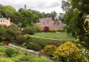
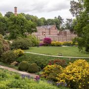
4. Cross and keep left on a broad path ahead, which leads to the main car park for Bidston Hill, just above the Tam O’Shanter Urban Farm on the left, where there is an opportunity to visit the café and toilets. It’s also worth walking out along the driveway to view the dramatic ruined chapels of Flaybrick Cemetery, a peaceful Victorian cemetery now designated as Flaybrick Memorial Gardens. The cemetery was laid out by Edward Kemp, an important Victorian landscape designer who worked with Joseph Paxton at Birkenhead Park, the first public park in the world and an inspiration for New York’s Central Park.
5. Returning to the Bidston Hill car park, from the far corner by a double litter bin, follow the path signposted to the windmill. Don’t take the first turning across the grass, but instead stay on the path to the left of the open area until you meet a crossing path (King George’s Way, so-called because George V and Queen Mary opened it to the public during a whistle-stop visit to Wirral in 1914) by a waymark. Go straight across onto a narrow path through the holly that leads shortly to the rear of a cricket pitch. Follow the path to the right, along the rear of the gardens then, ignoring a path to the left, cross an open heathy area, passing a bench, to the western scarp of Bidston Hill.
6. Turn right past another bench, again following one of Bidston’s bedrock ‘roads’. This leads straightforwardly along the edge to a footbridge over Vyner Road North, here in a deep rock cutting. Just beyond it is Bidston Windmill. A round socket on the left, marked by Heritage Trail waymark 6, once housed one of the flagpoles of the signalling station. Continue ahead past the old drinking fountain, with fine views to the right over Birkenhead and Liverpool, to the observatory. From the twin-domed frontage of the building, a short detour along the wall to the right leads to the Mummers' carvings, discreetly cut into a damp rocky step to the right of the path.
7. Returning to the main edge path, continue to the left of the observatory and lighthouse. Continue along the wall, the Penny-a-Day Dyke, supposedly referring to the payment rate earned by the workers building it to enclose the deer park. At Heritage Trail waymark 10, you pass the horse carving, now sadly eroded by generations of passing feet. Beyond the carving, follow the path left and down, alongside a sandstone wall, to the end of a driveway.
8. Follow the driveway down to the farm buildings at the bottom. Turn right between the boulders and retrace your steps past Bidston Hall and back to the village.
 David Dunford")
The Tam O’Shanter
The Tam O’Shanter cottage and free Urban Farm is run by a charitable trust with the aim of providing an enjoyable and educational experience for children and adults alike.
The historic cottage originated in 1700 and gained its popular name when a 19th-century occupant, a stone mason, decorated his cottage with a carved stone slab bearing the Burns poem. Sadly, the building was largely destroyed by fire in the 1950s and lost its listed status, but it was rebuilt by popular demand (and the carved slab reinstated). A further fire and subsequent vandalism led to threats of demolition, but it was again rescued from oblivion in the nick of time through the good offices of the Birkenhead History Society. It opened to schools in 1977 and became an urban farm in 1986.
Entry is free, and the farm is open daily from 9:30am to 5pm except Christmas Day, Boxing Day and New Year's Day. The range of domestic animals on display includes sheep, goats, pigs, alpacas, ponies, ducks and chickens. Visitors are welcome to feed the friendly animals, but only using the food provided for purchase.
The café is open from 9.30am to 4.30pm.

COMPASS POINTS
Area of walk: Bidston near Birkenhead
Start point: Bidston Church CH43 7QT
Distance: 2¼ miles/5.1 km
Time to allow: 1–2 hours
Map: OS Explorer 266: Wirral & Chester/Caer
Refreshments: Tam O’Shanter Urban Farm tamoshanterfarm.org.uk 0151 653 9332
Practicalities: Street parking only in Bidston. One minor ascent and descent; some of the paths on Bidston Hill may be a little muddy after rain.