Walking books in particular, and tourist guides in general, often promise to reveal ‘secret’ this or ‘hidden’ that. I’m cynical about this trope. I guess it’s an attempt to flatter our discernment and hint at exclusivity, but there are two problems with the idea, aside from its tired predictability. Firstly, the guilty parties often fail to deliver: between the covers you’ll often find the same list of well-known destinations that are in all the other books. Secondly, the conceit is a bit wrong-headed anyway – honeypots are usually popular for a reason, and elsewhere obscurity may be warranted. Not everybody is a sad completist like me (I may not get to walk all Cheshire’s footpaths in my lifetime, but I do have a vague scheme to step foot in every parish, however unpromising).
So, I hesitate to fall into the same trap by describing the countryside around Haughton and Spurstow in such patronising terms. But the area is certainly a humble Cinderella compared to showier sisters nearby. The sparse settlements and local buildings are interesting and attractive, the farmland is rich and productive, and its low hill offers intimate views of the entire length of the Peckforton Hills, from Bickerton to Beeston.
In times gone by, the area was certainly rather more celebrated and well-visited. Local brine springs, rich in naturally occurring sulphates, were believed to have curative powers. Sir Thomas Mostyn was convinced enough to build a formal baths, and a rhyming signpost indicated that 'if you are troubled with sore or flaw/this is the way to Spurstow spa'. The destination was described in mid-19th-century retrospect as 'formerly much frequented', though 'not at present in repute'. It’s in even less repute these days: all that’s left is an algae-covered pond you wouldn’t want even your dog to swim in, and the site is off-limits within private woodland and not worth the trespass (trust me). More interesting and approachable are the nearby Bath House and Salt House, historic buildings that served visitors to this once-exclusive destination. The former is a late 16th-century farmhouse with a Grade II* listing, the only building in the parish so elevated.
In walking, as in so many other aspects of life, exclusivity has a price. Here, that price is paid in stings and scratches: the local footpaths could use a little extra footfall and may be overgrown in places here and there. But bring a stout stick or pair of walking poles to bash the occasional nettle, and maybe leave the shorts at home, and you’ll have a grand day out in this little-known part of Cheshire. Walking aside, the rejuvenated Nag’s Head – mostly definitely a ‘hidden gem’ – will reward your journey into the unknown.
There’s a simple lesson to be had here, which applies equally well to pubs as to footpaths: use ’em or lose ’em.
1. From the Nag’s Head entrance, turn left along the road for a short distance and take a footpath on the right opposite Oak Farm. Passing a large pond in the garden on your right, and ignoring a kissing gate on the left, cross a stile to the right of a field gate at the end. Walk along the rear of the gardens and cross a footbridge over a small stream. Turn left and walk down the edge of the field, with the stream on your left, to a double stile and footbridge into the next field. Keep to the right-hand edge, passing a pond with benches and skirting a garden to emerge in Cappers Lane.
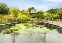
2. Turn right to a road junction and cross in front of the old school. Turn right along the pavement and continue beyond its termination. Opposite the entrance to Briar Cottage, turn left over a stile into a field. Cross parallel to the hedge on your right to a stile, then cross another into a paddock in the next field. Aim for the nearer of two horse shelters, via another intervening stile, then climb another stile into a service track. Turn left through a gateway and follow the fenced track between paddocks, one labelled ‘Middle Field 5’. Just before a bridge, turn left over an unmarked stile and follow the hedge on your right past a dilapidated brick building to a gate in the corner. Follow the path beyond around to the right and skirt the lake at Spurstow Hall, with enviable views to the house beyond. At the end of the lake, keep right to emerge on Long Lane.
 David Dunford")
3. Turn left to a road junction, where you turn right into Badcocks Lane. An obscure footpath on the left offers a shortcut across cultivated fields, but unless the path has been reinstated it’s probably easier and more pleasant to continue along the quiet lane to Pinfold Cottage. Turn left just beyond the house and follow another winding lane to a T-junction next to Bridge House. The Bath House and Salt House, worth a quick look, are a short distance to the left, but our route turns right. Ignore the track on the left at Coxey Green Farm and continue past Lower Hall Cottage. Cross a stile and follow the path beyond to Spurstow Lower Farm. Noting the pineapple-topped gateposts to the right of the farmhouse that are the only remnant of the original Lower Spurstow Hall, skirt right around the farm to a gate onto the farm drive. Keep right past the farm entrance then, just before the drive swings right to cross a stream, turn left. Follow this farm track past ancillary buildings then right to a gate, beyond which turn left through another.
4. This track beyond leads gradually uphill through fields, where there may be loose cattle. Continue climbing beyond another gate, then swing right. Bear left round a farm pit and cross the field to a gate and stile. Follow the hedge to the top of the hill, with wide views opening up around you. A farm track leads to a gate and beyond it the trig point, next to an unexpected pond, at the summit.
 David Dunford")
5. Beyond another farm reservoir on your left, and well before the communications mast, turn left through a farm gate and walk down the field edge to a double stile and footbridge in the bottom corner. Cross the next field, climbing slightly and passing to the right of a pond, to a gate at the top of a subsidiary summit. Beyond it cross a low mound, marking the site of a former windmill, with wide views to the east. Head down the slope to a gap into the next field. The formal line of the footpath here is along the left-hand hedge, but it may be more practical to continue along the farm track on the right to the corner of Spa Plantation. Either way, turn left on reaching the wood.
6. Just before the end of the trees, a stile in the fence on your right leads to a narrow path winding its way within the left-hand edge of the wood before exiting via another stile (if impassible, a track along the end of the wood is an easier alternative). From the end of the wood, head diagonally left across the track to the far corner of the next field, where a kissing gate leads via a hedged green lane to a paddock containing a pretty gipsy caravan. The enclosed footpath (again, potentially overgrown) skirts to the left and out to the road.
7. Turn right past the entrance to Spawood Farm and, ignoring a footpath on the left, continue past the brick buildings of Capper’s Lane Farm. At a slight bend, turn left over a stile and walk down the right-hand side of a series of fields separated by stiles (keep left of the hedge at a crossing footpath in the second field). Towards the end of the fourth, cross by a couple of oak trees to the left-hand side and follow the field edge to a kissing gate in the corner. Turn right down the short track back to Oak Farm and the Nag’s Head.
The Nag’s Head
 Beck Johnson and Claire Harrisson")
I first visited the Nag’s Head in 2009 and was pleasantly surprised to find a classy, clued-up outfit in such a remote rural location. Thus it was a blow to hear it had closed in 2019 and was slated for conversion to housing, then doubly gratifying to discover it had been reprieved.
Reinvigorating this 'proper English pub' – to quote the sign outside – is the latest project of North West hospitality royalty: Jenny Thompson and Nick Johnson, the pioneering couple credited with rejuvenating Altrincham Market and kickstarting a nationwide trend for co-operative pop-up-style catering and a communal, unpretentious family dining experience. And since re-opening last year they’ve brought all their knowhow and energy to the place. Jenny stressed their commitment to local, independent suppliers (credited enthusiastically on the menu) and you don’t get more local than the courgette flowers, ready to be lovingly stuffed with ricotta cheese, that she was bringing in from the garden when I arrived.
It almost goes without saying that the food is great, and includes plenty of veggie options and award-winning Sunday roasts, and the four cask ales are well up to scratch. Non-drinkers and those with a sweet tooth will welcome the alternative of quality coffee, independently and sustainably sourced, and a homemade cake.
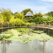
It’s not hard to see why Nick and Jenny fell in love with the place: the attractive timber-framed building is Grade II listed and incorporates the oak-beamed former village smithy. The gardens are extensive and have been planted with fruit trees and flowers, as well as herbs and vegetables for the kitchen. The couple plan to install shepherds’ huts for visitors seeking an upmarket glamping experience.
In the shorter term, Oktoberfest will be celebrated this month, and their regular Saturday activities for families will focus on the apple harvest, turning this year’s crop into pies, chutneys and more. The pub is open from Wednesday to Sunday, from noon in the week and from 9am at the weekend, and there is a large car park for patrons.
COMPASS POINTS
 OS MAPS")
Area of walk: Haughton and Spurstow
Start point: Nag’s Head, Haughton CW6 9RN
Distance: 5 miles/7.9 km
Time to allow: 2 to 3 hours
Map: OS Explorer 257: Crewe & Nantwich
Refreshments: Nag’s Head nagsheadhaughton.com
Practicalities: Stiles may be overgrown and fields may contain livestock. Numerous stiles. No public transport.