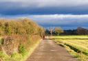
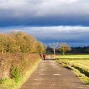
I never quite know how to place Disley. Technically it’s Cheshire East, but to me, it feels part Greater Manchester and part Peak District. It’s certainly well connected – bisected by the A6 and with its own station on the railway line from Manchester Piccadilly to Buxton – but within minutes of leaving the busy little centre you can be tramping rugged hilltop paths with wide Pennine views, or traipsing along the tranquil towpath of the Peak Forest Canal.
The ornate drinking fountain that distinguishes the centre of the village was a gift to the inhabitants from Richard and Thomas Orford in 1834. In use by local residents until the 1930s, it was fed from a spring near the church. It and its adjoining milestone are listed buildings, as are the nearby Ram’s Head pub and stables, the war memorial and adjoining K6 telephone kiosk, and the castellated former schoolhouse (now a surgery).
 David Dunford")
St Mary’s Church sits loftily above the fray on a steep little bank over the village centre and at Grade II* is also elevated above its lowlier listed neighbours by that all-important asterisk. It was founded as a chantry chapel at the end of the 15th century by Sir Piers Legh of Lyme (the fifth of nine peers to bear the same name), but he died before it was complete. Its nave and tower date from the following century and aisles were added in 1828. In the late 1950s, an Anglo-Saxon cross base was found in the churchyard. With its two sockets, it is similar in form to other double crosses in the area, such as the Bowstones above Lyme Hall, the Dipping Stone near Kettleshulme (see last November’s walk) and Robin Hood’s Picking Rods, just over the border in Derbyshire. This venerable stone is easily overlooked: it lies unobtrusively next to a bench and is planted with flowers.
The Peak Forest Canal runs for 15 miles from its junction with the Ashton Canal in Dukinfield to its twin termini in Derbyshire at Whaley Bridge and Buxworth. Its only locks are the flight of sixteen at Marple. The section below Disley opened in 1796 and is part of the upper canal, following the western contour of the Goyt valley with good views over the river and into Derbyshire.
 David Dunford")
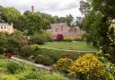
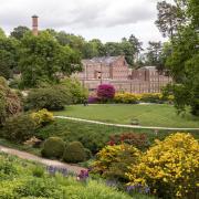
1. From the fountain in the centre of Disley, walk away from the A6 along the Old Buxton Road, to the left of the Ram’s Head. Take the first right, Red Lane. Turn left through the lychgate and follow the winding, stone-setted path (slippery when wet) up to the church. Turn right in front of the church building and walk out through the churchyard gate. Continue beyond the church car park, past the Old Vicarage on your right. Keep right at the first junction then turn left, with a sign reading ‘PRIVATE STREET’. Follow Red Lane, with views left to the Cage in Lyme Park, for a little under half a mile to the lodge and gates at its far end. Continue ahead to the National Trust tollbooth, where you turn right and follow the drive past a former fishpond on the right, over the railway and up to the A6.
2. Cross carefully and go over a stile opposite onto a fenced public footpath that climbs between paddocks up to a wood. Follow the path within the woodland that trends generally left then right, and follows a fence to a driveway at the entrance to Homestead Farm. Turn left and walk out to the road. If time is short, you can turn left down the road and jump to step 4, but you’ll miss out on some pleasant walking and wide views over Stockport and Manchester.
3. Follow the driveway opposite then take a path on the right that runs between a covered reservoir (right) and woodland (left). This emerges onto Disley Golf Course, where you turn left. Bear right and left past the 16th tee then take a path on the left, above the low quarry face on your left. The path runs beside a fairway, with wide views towards Winter Hill, then bears left past a stile and returns to the trees. Follow the path past a house back to Jackson’s Edge Road. Turn right and walk down the hill.
 David Dunford")
4. At a layby turn right, re-entering Disley Golf Course. Follow the obvious track across the course for a quarter of a mile or so, passing a pond on your right partway then, at a three-way footpath sign, turn left across a fairway to a gate into woodland. Follow the footpath downhill to a stile and pass above a marshy area on your right. Ignoring a path straight on, bear right along the slope below an old chimney that served a bone mill of the 1790s which used madder and ground bone to make dye for the printworks at Strines. Pass some buildings on the right then, immediately beyond a gate, turn right down a steep little path that leads into a wooded steam valley. Follow the stream downhill, eventually crossing it and continuing to emerge on the Peak Forest Canal. Turn right to a path junction, where you turn left to cross the canal bridge.
5. Turn right and join the towpath, here coinciding with the drive to Little Woodend Farm. Stay on the towpath beyond a lifting bridge.
6. At the next bridge (bridge 25) cross the canal and walk up to Hagg Bank Lane. Opposite a house called Sunnyside take a path through a kissing gate on the left and return to the canalside, now with the canal on your left. Follow the path to the pretty house called Waters Edge, featured on this month’s Cheshire Life cover. Leave the canal here and take the path to the right of the house, then follow the driveway out to the road. Turn right along the narrow lane, passing under a railway bridge on the way back to the start point in the centre of Disley.
 David Dunford")
The Ram’s Head
Housed in a prominent listed building in the centre of the village, a stone’s throw from the station, the Ram’s Head is a popular food pub. A mounting block outside the front door, and the extensive stables, reflect its former status as an important coaching inn on the route from Buxton to Manchester. An 18th-century visitor, one Viscount Torrington, declared it the 'best inn in England'. The current building dates from the 1840s but the original hostelry was built on the site by the Leghs of Lyme Hall about two centuries earlier, and the family’s emblem gives the pub its name. The stables once formed a more extensive courtyard and adjoined a large fishpond that was much reduced when Disley railway station was built in 1857 (the reduced remnant, still a sizeable waterbody, is passed on this walk as you exit Lyme Park).
Manager Ryan Nicholas was in full-on Christmas mode when I spoke to him, but he hinted that the menu may be refreshed in the New Year. Dishes are not limited to the usual pub staples: offerings that caught my eye included maple-glazed slow-cooked pork belly and scallops and, for vegetarians, freshly battered banana blossom – not a dish I’ve ever seen on a pub menu before. However, traditionalists in search of fish and chips, steaks, burgers or pizza won’t go unsatisfied. As the partner of a vegetarian, I was pleased to see a separate (albeit short) vegan menu. Brunch is something of a speciality, and is served every morning from 9am.
The pub is dog-friendly, including sections of the restaurant and there is a large garden to the rear. Parking is via a registration tablet inside the pub, or pay-and-display parking is available at the railway station. There is limited free parking at Disley Community Centre off Buxton Old Road, and on the station approach, though spaces tend to be at a premium.

Compass Points
Area of walk: Disley
Start point: Memorial fountain near Ram’s Head SK12 2AE
Distance: 3¾ miles/6.1 km
Time to allow: 2 hours
Map: OS Explorer OL01: Peak District Dark Peak area
Refreshments: Ram’s Head theramsheaddisley.co.uk
Practicalities: Minor ascent and descent and two busy road crossings. Several stiles, and a golf fairway to cross. The start of the walk is close to Disley railway station