There has been much talk of ‘15-minute cities’ in the press recently. The simple premise (if you ignore the petrolheads and conspiracy theorists, at least), is that anything residents need should be available within 15 minutes’ walking distance of their homes, without requiring them to get in the car. The usual examples given are shops, schools, workplaces, doctors and the like. But for me, one of the necessities of life is the ability to get away from the Tarmac and the traffic and into a bit of head-clearing green space. Chester is fortunate in that regard and needs no controversial road schemes to tick that particular box – minutes from the bustle of Bridge Street you can find yourself walking through remote-seeming watermeadows alongside the River Dee, watching the gulls scud by over the chilly waters and the winter thrushes flit between the hedgerows, with only the grand houses overlooking you haughtily from the Boughton bank opposite to remind you that you are still less than a mile from the city centre.
This invaluable green lung is known as the Earl’s Eye and occupies a long bend in the River Dee east of Queens Park and Handbridge. The land was given to the people of Chester by Harry and Phyllis Brown in 1929, and their legacy is maintained by the Friends of the Meadows group, established in 1980. The Earl in question was, of course, the Earl of Chester, and ‘Eye’ is an old word for ‘island’. In an Elizabethan document the area is referred to as the ‘Earl’s Eyes’ (plural) and the meadows are criss-crossed by drainage ditches, so it seems the area has always been waterlogged and prone to flooding. I found this out the hard way, when taking a foolhardy direct route across a low-lying bit of damp meadow below the Eaton Road, and ended up with sodden boots and socks that made for a chilly, squelchy walk back into town. With a bit more discretion it should be easy enough to stay dry-shod, but walking boots or wellies are pretty much essential during these wet winter months.
The return is straightforward and full of interest, and easier underfoot, as the route picks up the well-surfaced Chester Approach from the Duke of Westminster’s estate at Eaton Hall. This returns you to the Dee via the wooded Dingle, then under the mighty Grosvenor Bridge, past the Roman shrine to Minerva in Edgar’s Field, and thence back to the everyday hurly-burly of Chester.

1. From the Old Dee Bridge at the bottom of Bridge Street, walk upstream past the weir on the northern side of the river below the city wall. Pass the roundabout at the bottom of Souter’s Lane, followed by the bandstand. Cross the river at Queens Park Bridge, and on the southern bank turn left and left again, down steps to the riverside. Turn right, still heading upstream but now with the river on your left.
2. Follow the paved path below the gardens on your right, past the Boathouse pub on the opposite bank. Pass through a white-painted kissing gate onto Earl’s Eye Meadows. Ignoring a path off to the right, follow the riverside path around the long bend below St Paul’s Church, Boughton, on the opposite bank. After half a mile, ignoring any paths off to the right, you pass the jetty for the Sandy Lane passenger ferry (summer only).

3. Continuing alongside the river for a further 200m, you come to a fork. Keep left here, staying alongside the river, and pass through a kissing gate. From this point onwards the path is unsurfaced and may be muddy. At the end of the first field, cross a footbridge and continue alongside the river through a series of further meadows separated by hedges. Eventually, the path enters a wooded area and passes a pumping station. Continue beyond a bench and a low cliff and pass below a pink-painted house on a rise to your right.
4. After a kissing gate, the path returns to riverside fields. The path to Eaton Road heads off directly to the right here, over a low-lying section of meadow and up a steep bank, but to avoid wet feet and the slippery scramble, you may need to continue along the river past a fenced off section of the bank on your right (marked out of bounds for metal detectorists), and then double back above the slope along a grassy path. Follow the path along the edge of the field and out through a kissing gate to the Eaton Road in the corner. Turn right along the pavement and follow the road, past the sign for Handbridge, for quarter of a mile.
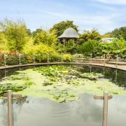
5. At the top of a slight slope beyond the entrance to Green Bank, cross the road and turn left through a white-painted kissing-gate into woodland. Follow this wide path, gradually heading away from the road on your left with an open area to your right, as it curves right to meet a surfaced drive.

6. Turn right and follow the drive for a little over half a mile, towards the end passing a hospital on your left, to Overleigh Lodge and its gates. Walk out to the road. Turn right and cross Overleigh Road at the lights. Turn immediately left and cross at a second set of lights. Go through the railings beyond and down a set of uneven steps into the wooded valley known as The Dingle. Bear right to meet another path, where you turn right. Pass under a high metal footbridge and continue to the Dee at the foot of Grosvenor Bridge.
7. Turn right under the bridge and continue to the end of River Lane. Follow the road past a couple of houses and then past an old quarry below the spire of St Mary’s, Handbridge. At the bottom of cobbled Greenway Street, go through the gates ahead into Edgar’s Field Park, and take the right-hand fork between two outcrops of sandstone. As the Old Dee Bridge comes into view, the amazing Roman survival that is Minerva’s Shrine is just off the path to the right. Continue to the main road by the Ship Inn. Cross with care and turn left over the old bridge to return to your starting point.

The Boathouse
You can’t get closer to the river in Chester than the Boathouse – indeed, when I visited the ‘waters of Dee’ were lapping slightly alarmingly below the windows, having submerged the lowest level of the riverside walkways upstream of the Queens Park Bridge. The pub has a near-unique floating beer garden, though to be honest that’s probably best left for the balmy summer months, rather than freezing February.
The pub is operated by J W Lees, the Middleton-based Manchester brewer, and serves their regular bitter, Manchester Pale Ale and Manchester Craft Lager. Food is well-regarded and includes plenty of choice for vegetarians. A healthy(ish) sounding starter of oak-smoked trout with pickled red onions, capers and horseradish cream caught my eye, but there are plenty of heartier pub standards on the mains and grills menus to fill you up after a chilly winter walk, and on Sundays the traditional English roast takes centre stage. From Monday to Friday they offer special prices for two courses (£14.45) or three (£16.95) on a selection of dishes from the full menu.
If you’re not local and fancy a relaxing overnight stay, the Boathouse has four double rooms and a twin, all with a nautical theme. All rooms offer free wifi and some have views over the river. Free parking is thrown in for staying guests as well.

Compass Points
Area of walk: Chester
Start point: Old Dee Bridge CH1 1SA
Distance: 5 miles/7.9 km
Time to allow: 2 to 3 hours
Map: OS Explorer 266: Wirral & Chester/Caer
Refreshments: Boathouse theboathousechester.co.uk
Practicalities: Riverside paths may be muddy (or even impassably flooded) after heavy rain. Boots essential.