

Once home to Sir Walter Raleigh today Padstow is probably best known for TV chef Rick Stein - but both share an important contribution to British cuisine.
Padstow is probably one of the UK’s most famous harbours, dating back centuries. The town is part of an ancient route known as The Saint’s Way. A string of ancient Celtic stone crosses, standing stones and Medieval churches along the way give some clue to the historical significance of this route which is thought to have been used by early Christian pilgrims and Celtic traders travelling from Ireland and Wales to Brittany and Spain. Travelling as they did, with their small coracles, and with treacherous seas around Land’s End it was safer for them to land at Padstow and cross Cornwall on foot.
The implication of this is that Padstow harbour has been in existence in some form for millennia, some suggest it was in use as early as 2500 BC. Look at a map of the north coast of Cornwall and it soon becomes apparent that there aren’t many places that can offer refuge to a mariner along this exposed and rugged coastline. Padstow is the exception, it lies in a natural harbour provided by the mouth of the River Camel and has quite steep land rising to its south west, protecting it from the prevailing wind. So it was geography which gave rise to the harbour but it was a saint that really put Padstow on the map.
It is said that St Petroc, one of the most influential saints to come to Cornwall, arrived in Padstow in 520 AD. He built a church close to the harbour and a monastery on the hill above. Standing at the entrance to the current St Petroc’s Church (the third to be built on the same location) it is interesting to reflect that this would once have been very close to the water’s edge. Since then a great many buildings and the current harbour have been built on land reclaimed from the sea so the footings are largely alluvial silt, sand and seashells. But until fairly recently, with the modern flood prevention scheme, it wasn’t uncommon to have tidal inundation of Padstow reaching Church Lane.

After the death of the great Anglo-Saxon King, Athelstan, in 939 there was a period in which the Vikings exerted their influence mostly in the north of the UK but they also invaded Padstow (then known as Petroces-stow), in 981 and ransacked both the church and monastery of St Petroc. The monks fled to Bodmin taking the remains of St Petroc with them, a fact confirmed by the record of Padstow in the Domesday Book of 1086 which stated that much of Padstow belonged to the monastery in Bodmin.
Much later, during the reign of Henry VIII with the dissolution of the monasteries the land which comprised the remains of Padstow monastery was given to the Prideaux family and in 1529 Nicholas Prideaux built Prideaux Place around the ruins of the old monastery. With such a history it shouldn’t come as a surprise to learn that Prideaux Place is now reputed to be one of the most haunted houses in Britain!
During the reign of King Henry VIII the Doom Bar formed. The Doom Bar is a naturally occurring sand bank near the mouth of the Camel Estuary. This sand bank can shift with storms and is continually built up by sand from far out to sea. It just so happens that around the time of Henry’s reign the Doom Bar moved closer to Stepper Point making the navigable channel between the bar and the headland very narrow and much more dangerous, particularly in the days of sail-powered ships.

The fact that the Doom Bar was created by nature hasn’t prevented the enduring quality of a popular myth that it was actually created by the mermaid of Padstow who was incredibly shot by a local man. She is said to have put a curse on the estuary as she was dying and since then the Doom Bar has accounted for hundreds of shipwrecks.
Over the years various aids to shipping have been contrived including the construction of capstans on the cliffs which were used to pull the ships away from the dangerous sand bank. Over the centuries much sand has been dredged from the estuary, one estimate suggests that about 10 million tons have been removed since the start of the 19th century and since it comprises mostly of shell-matter much of this has been spread onto surrounding fields to act as an alkaline fertiliser. Currently the Doom Bar isn’t quite so much of a threat because the natural channel is wider and further away from the rocks of Stepper Point but who knows what will happen in the future?
In the Middle Ages Padstow harbour became increasingly important as a point of export of copper and tin, as was the case in much of Cornwall, but also here there were lead mines and slate quarries making this part of the north coast quite distinct from the rest of the county. Like most other Cornish harbours fishing was a mainstay and pilchards played a significant part in supporting local communities with a staple food and a surplus to export. Coming the other way was coal from Wales, timber for pit props from Canada and sea salt for preserving the pilchards.

Ships coming from Canada with timber in the 19th century offered a cheap route for Cornish people wishing to emigrate, so Padstow harbour became a common route taken by people looking for a new life in the New World. Much of the imported timber was destined to be used in mines but it was also used to build boats. It was the fishing industry which drove the demand for boats to be built here in the 19th century and at that time there were six shipyards in Padstow.
Many of the harbour walls date back to the 16th century but most have been adapted, extended and built upon. The best example of how the walls might have looked originally is at Lower Yard, on the way towards St Saviour’s Point. Lower Yard was building ships until 1886, the last to be built there was The Amaranth. Ship repairs continued until in the 1890’s when an ice factory was built on the site. This quay is now grade II listed for its historical significance and can be seen from the coast path. The reason for the decline in ship-building was the use of iron to build their hulls.
In the Victorian era the area became a tourist hot spot. The beaches of Trevone and Polzeath for example were increasingly popular and in 1899 the railway arrived in Padstow making it the ideal spot from which to explore this beautiful area. Having a railway line allowed more fish to be transported to London for sale through Billingsgate Market, this in turn increased the number of fishing boats using the harbour and for the next few decades development of the various harbour walls took place. The branch line was closed in 1967 and during the 1980s this railway line became a popular cycle way, known as The Camel Trail.

In 1989 the inner harbour was created by extending the old walls and building new. This harbour remains ‘wet’ holding water from one high tide to the next and protecting the town from flooding during periods of rough weather or on very high tides. The added pressure of the new works on the old sections of wall caused some deterioration of their structure but in 2006 significant repairs took place and happily, the town hasn’t flooded since the defence scheme was finalised.
Today Padstow has a thriving fleet of fishing vessels, focusing on a variety of shellfish such as lobster, crab, scallops, oysters as well as fish. The harbour can accommodate vessels up to 2000 tons but fishing craft and yachts represent the majority of the harbour’s use.
In the year 2000 the National Lobster Hatchery opened on South Quay. This is a charitable organisation focussed on rearing young lobsters from eggs to a stage where they have a better chance of surviving in the wild, then they are released. Through their work they have enhanced the numbers of lobsters in the sea around Cornwall and through their research and publicity have been successful in encouraging other similar projects.
This continues to be a great success story for the town, helping to attract visitors and promote the green credentials of the county through its many television appearances.
Sir Walter Raleigh had a house in Padstow when he was Warden of Cornwall and was responsible for collecting taxes and duties in the late 16th century. Raleigh was credited with bringing the humble potato to Britain but I doubt he could have foreseen the popularity of this humble vegetable four centuries later when cut into finger shapes and deep-fried! Padstow has become one of the foodie capitals of the west country. This transformation has been driven by one man in particular, Rick Stein, whose seafood outlets in the town vary from fish and chip take-away to restaurant and café but there are plenty of other hostelries offering wonderful food in Padstow.

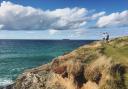
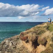
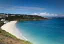
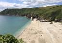
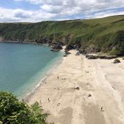
Padstow is a great place for walking. The Camel Trail is a popular path and cycle way which leads from Padstow harbour along the Camel Estuary to Wadebridge then as far as Poley Bridge on the edge of Bodmin Moor, a distance of 18 miles. The Saint’s Way has become a popular walking route, at 27 miles long it is usually done over two or three days. For a shorter walk head north along the west side of the estuary, as far as Stepper Point, this walk takes you past the lovely beach at Harbour Cove and the pretty hamlet of Hawker’s Cove.
Visit Padstow Museum to learn more about the history of the town and its harbour.
PHOTOGRAPHY
With the inner harbour holding water all the time there are always good reflections to be found at Padstow Harbour. Choose a calm day for best conditions. Try staying until the streetlights start to come on in the evening. Such dusk-time photos can be quite striking with the colourful yellows of lights making a striking contrast to the deep blue of the sky after sunset.

WILDLIFE
Padstow is a wonderful harbour for wildlife watching opportunities. In winter the harbour welcomes back a small flock of turnstones which roost on the boats and trot around on the harbour walls as tamely as you’d like! It’s also a special place for Mediterranean gulls in late summer. At any time of year there is the unique opportunity to walk or cycle from the harbour along the Camel Trail which gives great views over the estuary where thousands of birds come to feed, particularly in autumn and winter. Look out for little egrets, kingfishers, various waders, geese and ducks.
Summer brings the opportunity to get out on wildlife-watching boat trips and here Padstow is again uniquely placed in the county. This is the only harbour you can sail from with any realistic hope of seeing puffins. These comical, charismatic birds breed on The Mouls, an island off the headland known as The Rumps. Visitors can jump aboard the Jubilee Queen or the RIB sea safari boat to get close enough to the island to see the puffins, but they are only resident from May to July. Other wildlife to be seen offshore includes a fairly regularly pod of common dolphins, the RIB trips are great for getting visitors out far enough to see these quite close up.