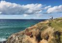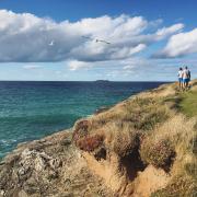

With its azure waters, golden sands and preternaturally beautiful light, St Ives has entranced many a visitor, from the artistic greats of the 20th century to the summer holidaymakers of the 21st.
The walk featured here is one of 30 signature hikes devised by Vespucci Guides for its Weekender series. These have been mapped out in collaboration with local enthusiasts, are stylishly presented (to the point that you could frame them once you return home), and come accompanied by a booklet revealing historical nuggets and recommendations for places to stay, eat and visit.
As well as St Ives, you could choose to explore the Cotswolds, the Peak District, inner-city London and many others. Each pack costs £20 (£60 for four – a discount but still not cheap). The target market: a new generation of walkers who are keen to put down their phones and commune with nature. That said, you can scan the QR code on your map to find each walk online in the OS app.
Our route is a personal favourite of Alverne Bolitho, of Trewidden Garden in Penzance, whose family has lived in West Penwith for generations. It incorporates around half of the St Michael's Way, a 13-mile pilgrimage route from St Ives's Bay to St Michael's Mount and allows you to access all of St Ives’ well-documented charms while escaping the crowds for peace, fabulous views and [a chance to] feel ‘just that little bit more Cornish’.
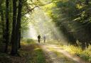
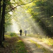
Follow the Atlantic coast from St Ives station to Carbis Bay; then strike inland towards Trencrom Hill, a Neolithic hill fort that once contained 16 hut circles. Legend has it the ancient boulders here were lobbed by the giants Trencrom and his cousin Cormoran, in play or in pique. At 167m, on a good day you can see both Carbis Bay and Mounts Bay from the summit.

Then head over to Knill’s Monument, a self-financed tribute to former mayor John Knill. Upon his death in 1782, he left money in his will for the upkeep of this obelisk, and for a five-yearly celebration in his memory - the next one is due in 2026. The paths here are well used by walkers and horse-riders, and rather muddy.
Although described by Vespucci as a shorter walk, it’s over seven miles and by no means one for beginners. That said, there is a short-cut option cutting out the hill (shame, though), and plenty of refreshment stops in St Ives and Carbis Bay – as you might expect, these dry up once you head inland. The directions are presented in sizeable blocks (I’ve broken them up and tweaked in places) and occasionally lacked precision, resulting in a couple of off-piste excursions and low-level bickering between the Other Half and myself. This problem was solved by switching to the online version, which enables you to see exactly where you are, and where you should be, which proved invaluable at the top of Trencrom Hill, when the directions advised us to head for the distant obelisk. It wasn’t the nicest day, and Knill’s monument was shrouded in murk. But do fight the urge to just stare at the screen rather than your surroundings.
The walk begins at the station, so do consider getting here by train, especially in summer; the branchline from St Erth is spectacular.

THE WALK
1. From the station, head down the steps towards Porthminster Beach and its cafe (public WC here). Keeping the sea on your left, follow the South West Coastal Path (SWCP) up and over the railway line. When the path forks, keep right and cross over Hain Walk Lane.
2. Follow the signpost for St Michael's Way and Lelant. Cross back over the railway line for magnificent views of Carbis Bay. Pass through the grounds of the Carbis Bay Hotel (last refreshment stop). Follow SWCP with the railway viaduct on your right. Head up the road, passing beach car park WC. Cross the railway line, leaving the SWCP.
3. Turn right and walk through Carbis Bay station car park. At the end, take the unmarked footpath to the left, past some houses and opening up to woodland on your right.
4. Cross the busy main road at the traffic island. Pick up the footpath next to Carbis Bay Holidays, heading uphill with a stream on your left. Look out for Knill's Monument on the horizon. Turn left at Wheel Speed Road.
5. At the junction with Polwithen Drive, cross over and turn left into Carninney Lane, which becomes a rough track. Ignore a footpath to the right, bearing right instead at Trewartha. Cross over the lane, signposted St Michael's Way and Trencrom Hill. Keep straight on, over a stile and through a field towards some metal sheds. Exit the field with the sheds to your right.
6. Continue over the road and up the stone steps. Trencrom Hill is directly ahead. Keep the edge of the field on your left and exit using the stone stile. Turn right with the equestrian centre on your left. Continue on the footpath, crossing over the stile and passing an isolated cottage on your right. The track heads downhill before crossing over the road diagonally to your left, signposted Trencrom Hill and St Michael's Way. Now heading uphill, cross over the lane, signposted St Michael's Way and Ludgvan. Take the right-hand path and head uphill to the top of Trencrom Hill.
7. With Knill's Monument on the horizon, head downhill towards a row of farm cottages, keeping a big rocky outcrop to your right and the large sheds to your left. Leave the field through a metal gate and a steep stone stile. Turn left onto the lane with the row of cottages on your right and the farmyard on your left. Turn right onto the footpath between Rose Cottage and Windwhistle. Head down through the field, keeping the fence to your right, exiting through a wooden stile and some steep stone steps. Cross the road and carry on gently uphill, on the track through a pair of cottages.
8. Turn left onto Laity Lane and follow uphill until it flattens off. After 1.2km, look out for the footpath to your right signposted Knill's Monument and St Michael's Way. Take the footpath forking to your right and you will arrive at Knill's Monument.

9. Retrace your steps, taking the right fork on the footpath and heading towards the radio mast. Head right down the lane, signposted Lelant and St Michael's Way. Be careful not to miss the left turn off the lane and onto the public bridleway. Head right at the footpath junction and then left onto the lane, passing St Ives School on your left. Cross over the lane beside Tregenna Castle Golf Course, passing the St Ives Bowling Club on your left.
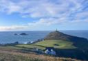
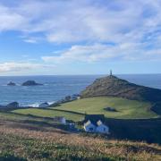
10. Turn right down the unmarked track at a house called Wetherby. Stay on the footpath, heading downhill with wonderful views towards St Nicholas Chapel. Cross over the stone stile and you will find yourself in the public car park beside the Leisure Centre. Head right to the corner of the car park before crossing over Trewidden Road and downhill, using the footpath. Turn right into Park Avenue and head downhill towards the beach with St Ives Harbour on your left; St Ives railway station will be to your right.
COMPASS POINTS
Distance: 7 miles
Time: 4 hours
Map: Vespucci Weekenders Signature Hike: The Cornish Coast, vespucciadventures.com (or OS Explorer 102 Land’s End)
Parking: St Ives railway station (or park at St Erth P&R and take the train into St Ives)
WC: St Ives and Carbis Bay
Refreshments: St Ives and Carbis Bay