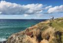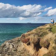

Blow away the cobwebs with this circular walk at Cape Cornwall, where mining and Methodism meet glorious Atlantic views at a location that’s on a par with Land’s End, but has lately been left largely untouched.
In geographical terms, a cape is defined as 'a headland, peninsula or promontory extending into a body of water'. There are only two capes in Britain: Cape Wrath in Scotland and, 850 miles away, Cape Cornwall.
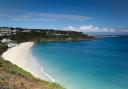
Marking the spot where the Atlantic currents divide, Cape Cornwall’s original Cornish name, Kilgoodh Ust, translates into English as 'goose-back at St Just', a reference to its shape and location.
In 1987, it was bought by Heinz as part of its centenary celebrations, and presented to the National Trust for the benefit of the nation, as denoted by a commemorative plaque near the summit.
The National Trust remarks that Cape Cornwall is often referred to as 'the connoisseur's Land's End', and this is surely because it has retained much of the wildness that has been lost in the development of Cornwall’s most south-westerly point.
When asked by some visiting Chinese friends to take them to Land’s End, we brought them here instead. They might have asked where the famous fingerpost was, but we felt justified in showing them something beautiful and untainted by human hand.
But, I hear you ask, what about the chimney stack? Granted, it’s quite clearly an industrial relic, but I’d argue adds a certain je ne sais quoi to the site, such is the romanticism around mining in these parts.

The stack dates back to 1894, when Cape Cornwall Mine was busy extracting tin and copper from under the sea. The remains of the mine are designated (and protected) as part of the Cornwall and West Devon Mining Landscape, a UNESCO World Heritage Site.
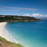
Out at sea are the distinctive Brisons, a pair of rocks known colloqiually as 'General de Gaulle in his bath'. Some say their name comes from the Cornish word 'Brissen', meaning prison, and reflects a former use of the rocks as an extremely primitive jail; others that it hails from the French 'brisant', meaning reef or breaker.
A major shipwreck here in 1851 resulted in the National Institution for the Preservation of Life from Shipwreck (later the RNLI) establishing a lifeboat in Sennen Cove in 1853, where it remains to this day. And during the regular Cape Sports Day held at Priest's Cove, hardy swimmers tackle the mile-long distance from the Brisons back to the beach.
Today, the Brisons offer an important breeding ground for seabirds such as gannets, fulmars and storm-petrels; look beyond, and on a good day you might catch a glimpse of the Isles of Scilly, 28 miles south-west.
Look out, too, for Ballowall Barrow, a prehistoric funerary cairn discovered under mining debris and excavated in 1878 by Cornish antiquarian William Copeland Borlase. Finds from excavations are stored in museums at Truro and the British Museum.
There are many walks to be enjoyed here, to Sennen Cove in the south or the Tin Coast and Pendeen in the north. Ours begins in St Just, the main centre of population in West Penwith with a strong tradition of mining and Methodism.
In July, the seven-day Lafrowda festival celebrates the local community and the arts. You’ll also find one of Cornwall’s most prominent ‘Plen an Gwarry' (Cornish for 'playing place') here - historically used for Cornish wrestling and medieval plays, and still employed for this purpose – the Ordinalia trilogy is set to be performed again in September 2025.
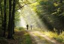
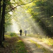
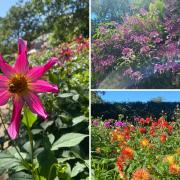
We chose a beautiful winter’s day, as the photos attest. However, during April and May, bluebells overtake the fields and clifftops above, creating a springtime spectacle easily accessible from the nearby car park.

The walk
1. Leave the car park and turn right to reach Market Square. Turn left, passing the war memorial clock tower on your left. At the junction with Cape Cornwall Street, take the narrow Chapel Street to the left of the main road.
2. At a T-junction, with the impressive Wesleyan chapel opposite, turn right and upon meeting the main road again, take the public footpath left along a narrow passageway in front of two cottages. Go over a stile and cross a small field to another stile, then cross the next field diagonally right.
3. Go over another stile, then bear left alongside the field-edge to yet another stile. Follow the path between trees; go over a stile and cross a road at a wastewater plant. Go over a stile and a footbridge to meet a lane down the Nancherrow/Kenidjack Valley.
4. Turn left along the lane. Keep ahead on a track at a junction by a house. Keep right at the next junction, and at the next take the road left downhill. At South West Coast Path signs, turn left along a path and across a footbridge.
5. Follow the path uphill, keeping right when it levels off at a junction. Keep right at the next junction to reach a road above Cape Cornwall.

6. Follow the road down right past a National Trust car park. Turn left at a gateway to a private road and descend granite steps. At a junction above Priest's Cove, turn left up a steep lane, then sharp right at the next junction to follow a stony track uphill to Middle Carn Gloose.
7. Follow a road past Ballowall Barrow and a mine stack, then turn right down a track. Keep ahead across two junctions to a surfaced road that leads between houses. Cross a wide junction and proceed up the lane opposite.
8. Turn right in front of a house to pass through a kissing gate. Follow the path to a stile, and cross a field to another stile. Turn left along the field edge to reach buildings, then go over a stile to reach a lane. Turn left, keep left at the next junction, and at a third junction, turn right to return to the car park.
COMPASS POINTS
Distance: 3 miles
Time: 2 hours
Map: OS Explorer 102 Land’s End
Parking: St Just – free
Refreshments: Cafes and pubs in St Just