Enjoy the wonder of woodland in our glorious Derwent Valley on this park and ride special.

Route
1. Start your walk at Ambergate beside the long, many-arched bridge that spans both a mill stream and the recently united waters of the Amber and Derwent rivers. Head along Beggarswell Lane, which is an access road to a series of properties tucked away in Shining Cliff Woods. The road gradually ascends the side of the valley with occasional glimpses across a landscape of wooded slopes pocketed by hilltop villages.
After the last property the tarmac lane becomes an almost level track through Beggarswell Wood. The Derwent Valley contains vast swathes of woodland, some of which is the remnant of the medieval hunting forest of Duffield Frith. It largely consists of ancient oak and birch, and is now designated as SSSI (a Site of Special Scientific Interest). In autumn the woodland creates a kaleidoscopic pattern of green, yellow, gold, grey and brown, mixing and merging in an ever-changing picture as you walk.
2. Turn right and descend a path leading to a large pond fed by Peatpits Brook. This was created as a reservoir to the former wire drawing mills, now redundant, located down by the river.

3. To the far side of the pond is a path heading uphill beneath sweet chestnut trees which meets up with a track that is the access route to Shining Cliff Hostel, which offers an ‘away from it all’ stay deep in the woods. Turn left on the track and walk along to a junction of paths, then bear right and walk uphill to a wall and gate at the corner of a field.
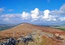
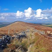
4. Go through the gate and head straight across the field with a wall on your right, bringing you to Park Plantation. A further gate then provides access into Alderwasley Park. Follow the pathway ahead to a line of pine trees where you will find ‘stump seat’ – the perfect place to enjoy a rucksack snack while taking in the glorious views. Notice the spire of the church at Crich peeping up over the skyline ahead.
5. Bear left to follow a grassy and gated track which forms part of the Midshires Way. It passes the Alderwasley war memorial, which is in the form of a cross set upon a base of large stones, situated at the side of Alderwasley Hall’s playing fields.
Set amidst mature specimen trees, Alderwasley Hall dates mainly from the 18th century and is Regency in style. In the past it was the home of the Hurt family but is now a private school providing specialist education, therapy and care for children and young people aged 5–19 years with speech, language and communication needs.

6. On reaching Higg Lane turn right and walk down past the Old Vicarage on your left and then past the entrance to Alderwasley Hall School and All Saints’ Church on your right.
7. At the base of Chapel Hill continue ahead to descend New Road. After a few yards glance up to see the gable end of St Margaret’s Chapel which is now used as the village hall. Thomas Lowe of Alderwasley built the chapel during the reign of Henry VIII but Francis Hurt had All Saints’ Church constructed nearer the Hall in 1850.
8. Opposite the entrance to Home Farm go through a small field gate on the left and follow a footpath which crosses a series of fields and stiles. Be sure to look across the valley to see Crich Stand atop its limestone cliff.

9. At a junction of five paths, where you will find footpath sign no. 416, turn right and descend to Whatstandwell Bridge. Be guided by posts and waymarker arrows on the final stretch of the descent down steps to a walled path, and then cross over a lane and pass through a small field to emerge beside the A6.
10. With extreme care go over the main road and then use the pavement to cross the river bridge, which has very low sides. A crossing of the river at this point has been recorded for centuries. In the 14th century it was noted that a previous bridge was washed away in a flood. The present structure is said to have been named after Walter Stonewell, the man who built it and who lived nearby. Wat is a common abbreviation of Walter and Watstonewell’s bridge was corrupted to Whatstandwell.
At this point you may choose to end your walk by returning to Ambergate by bus or train as the railway station and bus stop are close by.
11. To continue on the walk, head uphill on Main Road to access the canal path on the right. Walk for just over two miles along a stretch of nature reserve where ducks dabble on the still surface.
12. Leave the canal path at Poysers Bridge and walk down Chase Road. Turn left on meeting the main A6 and follow the roadside pavement. With extreme care cross over the road to walk beyond the Hurt Arms and past the cricket field and then turn right along Holly Road to end your walk at the bridge.
The little settlement of Ambergate evolved around 1817 when an Act of Parliament granted permission for a turnpike road to be laid from Cromford to Belper with a branch road leading from it to Bullbridge. The gated junction of these roads was close to the River Amber. So level and well-constructed was this new highway that it became part of the direct mail road between Manchester and London.
route details
Distance: Up to 6.5 miles
Parking: Limited free roadside parking on Holly Lane beside Birch Wood, Ambergate DE56 2HG Grid Ref: 345514
Public transport: Train – Whatstandwell & Ambergate stations (N.B. Please check due to current work at Derby Railway Station); TP Bus (Trans Peak) – various stops along the A6
Terrain: 10+ gates and stiles. Woodland paths with steps and trip hazards. Fields with livestock grazing. Close proximity to deep water. Low parapet on Whatstandwell bridge. Roadway without pavement.
Refreshments: Hurt Arms, Ambergate; The Family Tree, Whatstandwell
Toilets: No public toilets
Map: O.S. Explorer OL24 – White Peak
Walk highlight: Stunning views from ‘Stump Seat’
Description: This is a walk of contrasting halves beginning with a moderately strenuous field and stile hike around Alderwasley followed by a level path beside Cromford Canal, with an option to shorten the route using public transport, all the while enjoying the amber hues of arboreal autumn colours.