You may be recovering from an operation or a debilitating illness, ready to get out rambling again. You just need to take it slowly. Or perhaps your mobility isn’t what it used to be.
Here are three easy walks – all around two miles - in the Peak District. They are, by and large, on the flat and don’t have any stiles to be negotiated.
Included in these walks are some wheel-chair friendly sections.

From Conksbury Bridge to Bateman’s House – Lathkill.
This is a lovely 2.5-mile there-and-back riverside ramble, starting from Conksbury Bridge. There are a couple of parking laybys near the bridge.
Go through the gate (wheelchair accessible) and follow reedy riverside. Soon, views of the River Lathkill in all its beauty open out beside wide grassy banks.
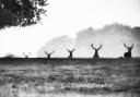
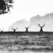
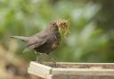
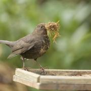
There’s a bench along the way, where you can pause and take in the mallards and other waterfowl on the water.
This section of the Lathkill is a Site of Special Scientific Interest (SSSI) and environmentally sensitive. Dogs should be kept on a lead, and neither the canine or human variety should paddle or swim in the water as the river vegetation and wildlife are easily disturbed.
The rewards for respecting the SSSI are dippers, grey wagtails and kingfishers that frequent the river along with water voles, white clawed crayfish and trout.
I love this section of the Lathkill, the stepped weirs, the wide grassy verges (sometimes grazed by sheep) and the gorgeous aqua-green and marine-blue water.
Summer evenings are a particularly good time to ramble here. I’ve wandered through when the waters have been eerily smoking (where the cooler river meets warmer air).
For wheelchair users, you can follow the first 510 metres (about three-quarters of a mile there and back) through a second gate and up to the top of the rise, with great views of the turquoise waters and weirs below.
Here those who find uneven ground unmanageable will have to turn back. If you can cope with rough stepped stones for a short section (there is a wooden railing to hold onto) you can continue to the bottom of Over Haddon.
From here the going is easy. If wheelchair users would like to drive round to re-join the walk here, there’s disabled parking a short way up the steep hill.
Continue along the concessionary path upriver into the National Nature Reserve. In springtime you might spot woodland wildflowers including the rare Jacob’s ladder (mid-June onwards).
Soon you will come to the ruins of Mandale Mine, one of the oldest mine workings in Derbyshire. This part of Lathkill is riddled with adits and old mineshafts. A sough drained the water here so lead could be accessed beneath the water course.
Continuing up the valley (look out for the sinkholes on the right), you’ll come to a curved wooden bridge.
Keep your eyes peeled for dippers – alongside the two-a-penny mallards. If able to, cross the little wooden bridge to Bateman’s House.
Thomas Bateman with his business partner, Alsop, set up the Lathkill Dale Mining Company in 1825. Their agent, James Bateman, lived in the house (now ruined) with his family, the building covering a novel water-powered pump designed to drain the mines.
You can climb down a steep metal ladder (mobility permitting) to view the old mineshaft, using the wind-up crankshaft to light it up.
From here, it’s just a matter of retracing your steps to your starting point

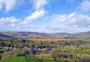
Along the Bradford
Short, but oh so very sweet, Derbyshire’s Bradford River is only four miles long. As with the Lathkill (the two rivers converge at Alport) the Bradford is home to water vole, white clawed crayfish and trout; kingfishers, grey wagtails and dippers. You may also see coots, moorhens and mallards.
Setting out from Alport, this two-mile saunter is wheelchair friendly (accompanied) but be warned the path can be muddy in rainy periods.
There’s some off-road parking on the Youlgreave road just above the hamlet of Alport. Drop down Alport Lane a short distance and through the white gate on your right.
If you’re lucky, you might spot the gorgeous Blawen mountain sheep with their curly horns that are usually grazing in the field opposite the farmhouse.
Continue along the track beside the Bradford. This area was also mined for lead (you’ll see evidence around the limestone cliffs).
The mineral-rich soil by the river is great for wildflowers. Look out for birdsfoot trefoil, lady’s bedstraw and rose rock through spring and summer.
Further along, there’s a bench tucked under a limestone cliff with lovely views to a charming humpback bridge.
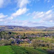
Soon you’ll reach Mawstone Lane at the settlement of Bradford below Youlgreave. Cross the road and continue beside the Bradford, here terraced by weirs into several fishing ponds.
The grassy verges on this section of river are great for a picnic (if lucky you can nab the bench overlooking the water). The pooled river here is deep enough to do a spot of wild swimming (for a very short distance).
As I walked by in January, one intrepid lady was taking a dip, the water, she informed me, a chilly 7-8°C. In summer, this area is very popular with families who come to cool off.
Continue on until you come to Holywell Lane. If you can’t cope with gradients, turn back to retrace your steps, otherwise climb the steep hill into the village of Youlgreave.
Turn right to take the road back to Alport. You will pass two pubs and a village shop serving takeaway coffee and delicious tray bakes. Once past the church, there’s a narrow pavement dropping back down to the hamlet of Alport.

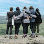
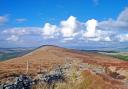
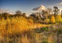
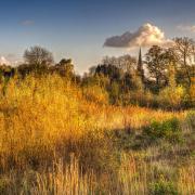
On Baslow Edge
For wheel-chair users, you can do the first 260 metres to the viewing point (less than a third of a mile there-and-back).
Cross the road from Curbar Car Park (aim for a weekday or early morning or evening as it fills up quickly) and follow the path along the wall boundary, going through the wheelchair friendly gate.
Keep right to reach the viewing point where the edge dramatically drops away to the Derwent Valley below. An information board will help pinpoint Baslow, Calver, Curbar and Eyam settlements.
High points include Longstone Moor, Hucklow Edge, Win Hill and Kinder Scout. It’s one of the finest views in the Peak District.
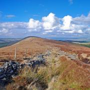
For those who can negotiate the occasional rise and smallish embedded boulder, continue across the edge, keeping as close to the escarpment as you can.
The path is mostly flat and even and the views spectacular, as are the rock formations teetering on the edge.
Soon, views of Chatsworth open out – what a fine location it is for a stately home.
Eventually the path curves left, bisecting a broader path. Continue to Wellington’s Monument. The duke’s date of birth and death are inscribed on the stone cross (1769-1852 since you ask).
There’s a bench beside the monument – a fine spot for a picnic or coffee stop. Retracing your steps to the crossroad of paths, turn right onto the broad (although rutted path), passing Eagle Rock (where agile boulderers scale the outcrop).
If you need a flatter surface, you can simply do a there-and-back ramble along this wider sandy path, but you will miss out on far-reaching views.
The lovely vintage van – Jolly's – parks at Curbar Gap Car Park at weekends (Friday-Sunday) to tempt you with coffee, hot chocolate or tea with cake, a satisfying end to this scenic two-mile walk.