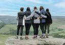
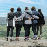
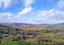
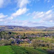
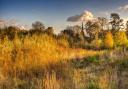
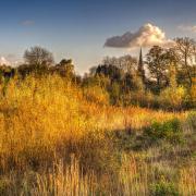
This epic 11-mile walk around Chesterfield takes in diverse terrain: canal, rewilded industrial works, wetland, woodland and high-level countryside with expansive views across Chesterfield and the settlements of Northeast Derbyshire.
There are a few short sections of busy road without pavement you must tackle to link up the countryside pathways. Walk them with extreme caution, but the rewards along the route are ample.
")
1. Parking on Station Road by the canal on the edge of Brimington (on the other side of the waterway from The Mill pub), head north along the Chesterfield Canal.
Named the Cuckoo Way, the towpath hugs the waterside with its moorhens, coots and mallards for two miles to Hollingwood Hub, an information centre and café.
Linger for breakfast in a bun and to gen up on the history of the canal. From here, continue along the canal another mile, passing below Staveley, until you come to a black-and-white brick-ended bridge. This is where you leave the canal.
2. Turn left down steps opposite the bridge, a path funnelling you between metal fencing of the old Chesterfield works, now being reclaimed by nature.
Steps lead up and over an old railway embankment, through a wet underpass (wellies are essential in rainy periods) and over a bridge onto a capped landfill site. The path climbs diagonally from the boundary past a wetland pond and up onto the heights.
Turn right to follow the path to Hall Lane. Across the land, part naturally rewilded with birches, part replanted by man, you’ll see a scattering of great black bins – collecting gases from the decomposing waste of the old landfill site.
This abandoned waste disposal site is surely a haven for wildlife, the skylarks making their voices heard as I passed through.
")
3. Turn left onto the busy ‘rat run’ of Hall Lane, taking extreme care: walk on the side of oncoming traffic, cross on blind corners and use grassy verges where possible.
After a short distance you come to a crossroads. Turn right down the altogether quieter Breck Lane, descending then climbing to the handsome farmhouse of White Lodge Farm.
Take the field track (bridleway) opposite it, following field boundaries into a third field. Turn left onto a farm track, then right through a gap in the hedge, staying on the bridleway that follows another field boundary to Staveley Lane – the heart-lifting skylark song possibly your soundtrack along this entire section of the ramble.
")
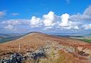
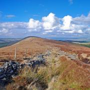
4. Turn right and climb the road with care. At the bend follow the second fingerpost along a track cutting over to Springwell Hill.
Turn right and climb the road for a short distance (keeping to the grass verge), taking a left-hand footpath to cross a series of fields (the path clearly defined) before heading southwest to Manor Farm with its lovely wood-carved animals, its emus and geese – and a skeleton leaning over a picnic bench, who’s clearly had to wait a ridiculously long time for table service!
5. Turn left and walk along the pavement of Main Street to its end. At the junction cross the road and follow the fingerpost into Stubbing Wood, muddy and overgrown in places. Take the second left over a planked footbridge and carry on to the edge of the woodland. Take a left to follow the woodland boundary a short distance, then right into a field.
Drop down to a crossroad of pathways in the field, turning right there to head towards the first house at the field’s end. Cross a private lane into more woodland. At its other end, drop down through a field to cross Grasscroft Wood.
From here follow the clearly defined path down through fields towards New Whittington, following in the direction of the tall wind turbine, the sprawl of Tesco and Chesterfield’s spire beyond. Cross the footbridge, turn left into woodland, reaching the wall of a cemetery.
6. Turn left again to drop down to Whittington Green School. Turn left once more and continue along the pavement of High Street in New Whittington. Cross the road at the island to drop down Burnbridge Road.
Where the houses end on the left, go through the squeeze bars into Brearley Wetland Nature Reserve. The last section over boardwalk leads to Station Lane.
Turn left and walk the road for a short distance before crossing a stile on the right into a horse paddock.
At the other end, go through the gate to continue between the metal fence and the River Rother.
7. Go under the tunnel of the old railway and continue following the river until you come to a crossroads of paths.
Turn right over a bridge to reach the canal, then right again to retrace your steps along the towpath back to your starting point.
This delightfully varied walk gives you a birds-eye view of Chesterfield and its crooked spire. Take care on the short sections of pavement-less roads; you walk them at your own risk.
Make sure you have an OS map with you as there are many twists and turns along the way. And enjoy.
Easy alternative: Walk the Cuckoo Way towpath as far as to Hollingwood Hub. The there-and-back four-mile ramble is wheel-chair accessible and flat.

COMPASS POINTS
Distance: 11 miles
Grid reference: SK 3926 7372
Map: OS Explorer 269, Chesterfield and Alfreton
Difficulty: The Cuckoo Way section is flat and even. There are some gentle inclines as well as wet and partially overgrown sections in the old Chesterfield works and in woodlands. Awareness is required on the short road sections.
Parking: Bluebank Pools Nature Reserve Car Park (beside the canal towpath)
Refreshments: Hollingwood Hub and The Mill, Station Road, Brimington.