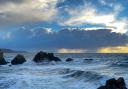
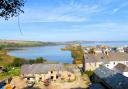
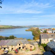
The furthest north-west corner of Devon is a very long way from anywhere else in the county. A very long way. This is a land of steeply rugged, craggy coastline and sequestered sylvan combes, places with few people and plentiful wildlife. It is a beautiful area, well off the beaten track and nestled against the Cornish border.
I had planned to start us off from the beach at Welcombe Mouth, but the lanes and track that lead to the National Trust car park seem so abandoned that it’s probably better to start at the gorgeous Old Smithy Inn at Darracott. Here walkers are allowed to park as long as you give them your car registration in advance and then partake of their hospitality – which I highly recommend!
If you don’t wish to do this, then you will need to drive slowly and carefully to the coast, with a well-harnessed sense of adventure (see Compass Points). For those doing this, be prepared for a strenuous start to the walk.
I know many readers save winter walks for a more clement season, so if you’re walking in fair weather you’ll be rewarded with a richness of wildflowers throughout the walk: scabious, wild honeysuckle, toadflax, lesser stitchwort, to name a handful.
From whichever point you start, and in whichever season you’re venturing forth, you will be rewarded with a spectacular and memorable walk. Clear weather is vital.
THE ROUTE
 Simone Stanbrook-Bryne")
1a. Starting at Welcombe Mouth: Follow the acorn-waymarked South West Coast Path (SWCP) steeply uphill, sea to your right. If you’re doing this in summer, don’t step on the big furry caterpillars that share the path.
Steps aid the ascent and you eventually reach a memorial bench to Harold Keays. Just past this you find a footpath going left, which is the point at which those who have started at the Inn will join you.
 Simone Stanbrook-Bryne")
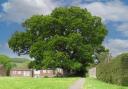
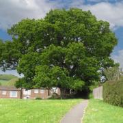
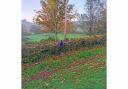
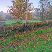
1b. Starting at the Old Smithy Inn, Darracott: From the grassy triangle at the road junction, follow the lane signed for Welcombe Mouth, passing the pottery on your left and the gate into the inn’s garden on your right. In 200m you reach tracks going left and right. Take the one on the left (there was no sign to say it’s a footpath, but there may be by the time you arrive). This is the drive to Witheford; it goes down and up and bends a bit. In about 100m, before you arrive in their yard, look for the narrow path heading right off the track through the trees – there is a well-concealed sign.
Follow this clear path, which soon reaches a crossing path. To your right is a view towards Welcombe Church, but our walk goes left, soon passing through an arrowed gateway into a field. Turn right in the field and now follow the right-hand hedge through four fields. In the fourth, very small, field you’ll see the buildings in Mead ahead. Near the end of the field veer over to the left-hand corner and follow the fenced path to a stile.
Cross this into a private garden – we met the lovely family and their gorgeous dog, but please respect their privacy. The footpath goes past the front of their home, then follows the drive, past other houses and out to the lane.
Turn left on the lane and follow it for 80m, then take the footpath going right. Follow the track for 170m, then cross the stile into the field. Follow the right-hand boundary through two fields – there is a distinct whiff of the coast ahead. At the end of the second field cross a stile and you’re on the acorn-waymarked South West Coast Path.
(Those finishing the walk here turn right on the SWCP, to retrace back down to Welcombe Mouth.)
 Simone Stanbrook-Bryne")
2. For those who started the walk at the Inn, turn left along the coast path. You are now joined by those who started at Welcombe Mouth, heading towards Cornwall, sea to the right.
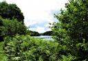
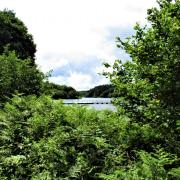
The path starts to descend towards Marsland Mouth, the spot where Marsland Water meets the sea – the county boundary mostly follows this waterway.
 Simone Stanbrook-Bryne")
Our way soon passes the writing hut that once belonged to the poet Ronald Duncan. The hut was built on the site of an old lookout in the 1960s and was restored as a memorial to him by Duncan’s daughter. The place stands testament to poetic inspiration afforded by land and seascapes. Here we met a woman from Warwickshire who was part-way through the whole SWCP, and we had a chat about poets – one of those lovely, chance encounters that so enriches a walk.
From the hut, steps lead steeply down the cliff and the path eventually swings inland towards the white building of West Mill.
 Simone Stanbrook-Bryne")
3. At the three-way finger post our way leaves the SWCP and heads inland on the public footpath. Follow the path through a gate and past West Mill, where you reach a crossing track. Turn left, heading uphill along the side of the Marsland Valley.
Ignore an unsigned path going right and continue uphill on the track. The woodland of the Marsland Valley is over to your right, stretching inland behind the coast. The footpath reaches a gateway with adjacent stile. Keep straight ahead up the lane, passing an entrance to the Devon Wildlife Trust’s Marsland Valley Nature Reserve. In 150m the lane arrives at Mead Corner. Take the signed footpath heading right, through a gate.
 Simone Stanbrook-Bryne")
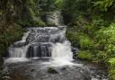
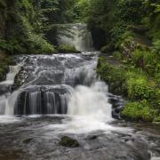
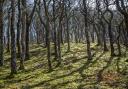
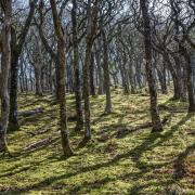
4. Head down the field – the line of the footpath shown on the map is quite overgrown; you’re in the nature reserve, and nature quite rightly takes priority – so just go straight down into the valley until you reach a broad crossing path. Turn left along this and follow it until you reach an arrowed stile into the trees. This is a truly lovely stretch of sylvan walking, right on the very edge of Devon, and has the added advantage of being steadily downhill. Marsland Water is down to your right, though isn’t always visible.
After about half-a mile the path emerges from the trees, goes through an arrowed gate and passes an idyllically situated cottage on the left. Continue alongside their garden, go through a kissing gate then turn right along a track. Marsland Water is to your right and you soon cross a small bridge – for a few moments you’re in Cornwall, so, if you’re consuming scones remember: jam first. A Cornishwoman once told me that when you bite into a cream tea, the first thing you taste dominates, hence they put cream on top as it’s bland, and won’t dominate the taste of the jam beneath. Even as a Devonian, I confess she has a logical point.
5. The track passes Rosemarsland, then bends left to pass Gooseham Mill. Continue along the track, which soon arrives at the lane. Turn left to arrive at a restored stone barn, home to bats, according to the sign, and an information board about the Marsland Valley. This is now one of the DWT’s largest reserves but was originally bought as several pockets of land in the 1960s by an enlightened Christopher Cadbury, of chocolate fame, to create a wildlife refuge.
From the info board, continue in the same direction as before, passing the info board and barn on your right and keeping ahead to join a rough track. You soon cross a stone bridge, returning to Devon.
Keep going along the track, plodding upwards. You pass a memorial bench and post for people who loved the ‘sport and serenity’ of this place. Given that one of the signs mentions motor sports I couldn’t help but ponder its impact on the serenity.
 Simone Stanbrook-Bryne")
6. Just after this ignore a bridleway going right and stay with the rising and bending track until you reach Leddon Farm. Follow the track out to the lane in Darracott, turn right, and in about 200m you reach a grassy junction in the middle of the hamlet.
For those who are finishing here, refreshment awaits. For those who are heading back to Welcombe Mouth (as we were), sustenance here is recommended – the inn’s copious sandwiches and coffee set me up for the final stage. So, those continuing should now follow the directions in 1b, above, and when you reach the coast, turn right and retrace your steps – steeply and with caution - down to your start point.
 Simone Stanbrook-Bryne")
5 things to do while you’re in the area
The Old Smithy Inn is a must; it’s a delight to find such a lovely place in such a remote spot. See Compass Points for contact details
Welcome Pottery in Darracott is a good place to call into and also has a café – check the website for opening times
St Nectan’s Church in Welcombe village is deeply historic. It has an 11th-century font, one of the oldest rood screens in Devon, a William Morris stained-glass window and, in the south transept, we found a very touching, clear glass silhouette or a man, designed as a war memorial: “Here but not there”.
 Simone Stanbrook-Bryne")
 Simone Stanbrook-Bryne")
Outside the church look for the lovely bench donated in gratitude for the kindness shown to Wendy Jones during her evacuation here in the Second World War. Across the road is the Holy Well, from which Welcombe is thought to derive its name.
Welcombe Farm Shop is just outside the village and is another friendly place that offers coffee.
 OS Maps")
COMPASS POINTS
Start point and parking: Old Smithy Inn, Darracott, Welcombe.
Postcode EX39 6HG; grid ref: SS231178. Contact them in advance to give car registration and arrange to take refreshments there (they also do B&B). 01288 331305; info@theoldsmithyinn.co.uk.
If you don’t want to do this then there is a National Trust Car Park on the coast at Welcombe Mouth (marked clearly on OS map) at grid ref: SS213179 – but please take heed of challenging access that I describe in the Introduction. If you start at the coast you will need to skip Point 1b until you near the end of your walk
Map: OS Explorer 126, Clovelly & Hartland, 1:25 000 (this scale shows greater detail than the map printed here)
Distance: 4.5 / 5 miles
Terrain: Field, coastal and woodland paths and tracks. May be muddy. Very quiet lanes
Exertion: Very strenuously hilly in places. A particularly steep ascent if you start from Welcombe Mouth
Dog data: Animals grazing. Edges along the coast. Very quiet lanes. Most of the stiles should be manageable by most dogs. The inn welcomes canines
Refreshments: The Old Smithy Inn – see details above. Welcombe Pottery, opposite the inn, also has a café, but not open every day (01288 331506)
Note: Make sure weather conditions are clear
Look out for:
Superb coastal and inland views
Ronald Duncan’s hut
Historic church
Holy well
Historic pub
Walking 1000 miles: During 2023 Simone is walking 1000 miles to raise funds for the Devon Wildlife Trust. If you’d like to help support this charity and the Big Walk, please visit: justgiving.com/page/simone-stanbrook-byrne-1678009505575