The peaceful face presented by the enchanting South Hams is one of Devon’s many charms. However, this place of idyll was once an area of deep turbulence and distress – something a farming friend of my family still remembers very clearly from her childhood.
In November 1943 it was decreed that 30,000 acres behind Slapton Beach should be evacuated in less than three weeks, displacing some 3,000 people and 180 farms. This was to enable 15,000 Allied troops to practice for the D-Day landings. My friend tells me that her parents were told that they could leave belongings in the attic, where they would be safe until their return 11 months later – but on their return, all their tucked-away chattels had gone…
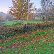
In April 1944, during Operation Tiger, a disastrous combination of enemy attack and so-called ‘friendly’ fire, resulted in more than 1,000 deaths. The mighty Sherman tank in the car park where we start the walk, stands as a memorial to those who died.

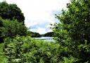
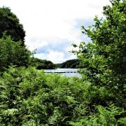
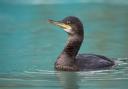
So, a sobering start to a really beautiful walk, whose landscapes and expansive seascapes change with the seasons. The freshwater lakes of Slapton Ley and Widdicombe Ley, lying behind the coast, are key features of the route and are brilliant for birding.
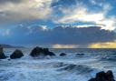
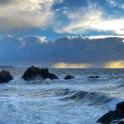
Pick one of those crisp bright February days, wrap up warmly, and enjoy the architectural beauty of naked trees and the white-crested waves along the coast, raised to turbulence by winter storms. And watch your step - it can be slippery underfoot on stony sections. It’s not the fall that hurts but the sudden stop!

1. The car park lies alongside Slapton Ley, and there is a bird hide at one end which might interest walkers with binoculars. At the end of the toilets (on the Sherman tank side), leave the car park by the pedestrian exit and cross the road towards the sea. When you reach the sea wall turn right, following the South West Coast Path (SWCP, look for the acorn waymarks). The sea is to your left.
Head along the front until the sea wall ends near Boathouse Cottage, then climb the steps. At the top follow the stony path, from which there are splendid views to the right along the coast towards Froward Point and Scabbacombe Head, and across Slapton Ley. It is a panoramic arrangement that doesn’t look quite real.
The path widens near The White House. Keep straight ahead along the SWCP – the sea is behind you at the moment. Very soon the SWCP reaches a surfaced lane; turn left, uphill, following the winding path past the red garage doors of Cove Ark. Yellow arrows direct all the way and you’re climbing steadily, but the reward soon comes when the way opens up to a broad grassy path, with views along the coast to Start Point Lighthouse.
Along here, hanging on the right-hand fence, there is distinct evidence that the age of romance isn’t dead and Pete has clearly earned himself a few Brownie points with Kathy.

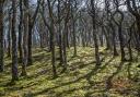
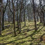
2. Soon the SWCP curves inland beneath trees as it winds its way round the disused Beesands Quarry, a source of sand from the 16th century, and also roofing slate. It is now a testament to nature’s wonderful capacity to heal itself and regenerate.
Follow the path all the way round the old quarry – watch your step as the stony sections can be extremely slippery. At one point there’s a good view across Widdicombe Ley.
The path heads seawards again and the village of Beesands comes into view, with the distant twin masts near the further village of Hallsands.
Almost as soon as you leave the trees around the quarry you reach a three-way fingerpost. Leave the SWCP here and head inland on the rising footpath, immediately passing a concrete structure on the left, part of the old coastal defences. Go through a footpath gate and continue along the left-hand edge of a long field. A small mast up to the right looks like it’s celebrating a first birthday. Soon you’ll have coastal views to the left.

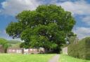
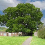
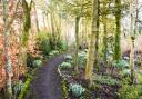
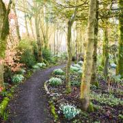
3. At the end of the field head slightly right uphill to the yellow-arrowed footpath gate; cross the track beyond, go through another arrowed gate opposite, then follow the woodland path. This lovely sylvan path reaches a fence in about 300m, just before a couple of houses: Widdicombe Thatch and Widdicombe Cottage. A two-way fingerpost directs along a narrow path alongside their forecourt.
Continue along the surfaced drive until it widens near the entrance splay of Widdicombe House. Walk away from here as directed by a fingerpost, still following the surfaced drive, until you reach a yellow-arrowed post on the left in about 150m. From here go obliquely left, back on yourself, along an enticing path beneath trees.
When the path forks keep right, passing, on your right, an entrance to the private walled garden of Widdicombe House, which is behind the hedge to your left. Go through a footpath gate and keep ahead; the outbuildings of Widdecombe House are to the left. Cross a track and keep straight on to another arrowed gate. Go through, walking towards big countryside views ahead.
Continue along this line, downhill through fields, until you reach a gate at the bottom near the buildings of Lower Widdicombe Farm, a rather glamorous holiday ‘cottage’.

4. Leave the field, turn right along the surfaced track for few metres towards Lower Widdicombe, then almost immediately left down another track (arrows and fingerpost direct). In 70m, when you reach two gates, go through the right-hand one (with arrows) to join a downward-sloping green lane beneath trees. The path crosses an open area with fields to left and right; keep ahead as the way becomes enclosed again and about just over a quarter-mile from Lower Widdicombe you arrive at the houses of Beeson.
Leave the green lane and bear right, passing houses. You reach the road junction in 30m, where a sign says Lower Beeson Farm. Turn left on the road, passing Swallowfield, then Lower Beeson House, both on your right.
5. In 200m you reach a road junction near Orchard Cottage. Turn left and follow the road for almost half-a-mile, passing Sugar Park Campsite. The road starts to descend and bends right, left and right again – and at this bend there is a concreted parking area ahead with a sign for Britannia @ the Beach.
Leave the road and just within this parking area look for the signed footpath on the left. Go through the kissing gate and turn right down the field, following the hedge with Widdicombe Ley down to your left; mute swan may be floating on their own reflections.
In the bottom field corner go through the gate and continue down the next field, at the bottom of which you emerge into the area behind the beach.

6. Beesands is to the right, but our walk turns left and joins the signed SWCP in the corner of a car parking area. Follow this as it heads away from the sea for a few metres then swings right – the sea is some way over to your right, beyond the grass, and you soon find yourself walking close to Widdicombe Ley. The striking white properties ahead are Sunnydale and Beesands Cellars, and this is where you’re aiming. A well-placed bench is another good spot to give the binoculars some exercise.

The SWCP soon swings right, back towards the coast, then left again, ambling behind the beach. When you reach Sunnydale the path swings round behind the houses and continues uphill. You reach a three-way fingerpost that you’ve seen before, and now the return trip to Torcross is a retrace along the SWCP, passing Beesands Quarry again.
As you approach Torcross, keep an eye open so that you retrace along the correct path: after the red garage door of Cove Ark look for the rough path going right, back towards The White House, the steps down to the sea wall, and the easy stroll back to the start point.

COMPASS POINTS
Start point and parking: Torcross Car Park. Postcode: TQ7 2TQ; Grid ref: SX823423
Map: OS Explorer OL20 South Devon, 1:25 000 (this scale shows greater detail than the map printed here)
Distance: almost 5 miles
Terrain: South West Coast Path, field and woodland paths and tracks. May be muddy; stony sections slippery. Very quiet lanes
Exertion: Moderate with strenuous sections along the coast
Dog data: Animals grazing. Edges along the coast. Very quiet lanes en route and a busier road in Torcross
Facilities: Lots of options in Torcross, plus Britannia @ the Beach in Beesands (01548 581168). Opening times can vary seasonally so check with individual venues if you plan to call in. There are toilets in the car park
Look out for:
Expansive views
Rich birdlife
Start Point Lighthouse
5 things to do while you’re in the area
1: Slapton Ley is a National Nature Reserve and it’s well worth spending time here to spot a few overwintering birds.
2: The Cricket Inn at Beesands is a lush venue for eating and staying.
3: Start Point Lighthouse is open to the public at certain times and is an interesting place to visit.
4: Hallsands is just along the coast, where the cliffs are the site of a village lost to the elements. Some evocative ruins still cling on.
5: Dartmouth, with all its enticements, is less than 10 miles to the north of Torcross
Simone has written a series of West Country walking guides, including Circular Walks in the South Hams