This From River plains walk takes in a 14th century castle, a working quarry and a perfect example of a Victorian church makeover

We're going all 'Pre-Domesday' on this intriguing walk in the Frome River plains. Of the two holdings recorded in the Domesday Book which are our focus on this walk, East Woodsford was held by St Peter's Abbey at Cerne with 4 villagers, 3 smallholders and 5 slaves. The manor of West Woodsford was held by William Belet with 2 villagers, 2 smallholders, 4 slaves, a mill, extensive meadows and pasture.
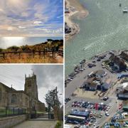
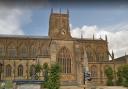
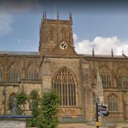
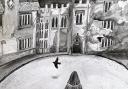
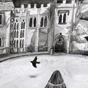
East Woodsford survives as the village we're visiting with St John the Baptist's Church, built in the 13th century and still exhibiting masonry from this period in the lower levels of the tower and the tower arch inside. The rest of the church was rebuilt by T. H. Wyatt 1862-63 as a 'perfect Victorian vision of what a church should be'. Look for the scratch sundial on the wall right of the south porch.
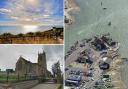
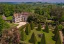
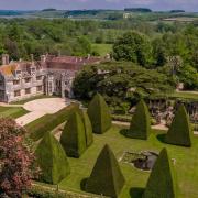
West Woodsford consists of 14th-century Woodsford Castle and earthworks of the deserted medieval village street, individual plots and hollow-way leading to the ancient fording point of the River Frome. After the Belet family's tenure of West Woodsford manor, William de Whitefield started building the Purbeck stone manor house and was granted a licence to crenellate (add fortification battlements) in 1335. Guy de Brian bought the estate in 1367 and, three years later, he finished building the 'castle', complete with five square towers (only one of which remains, in the north-east corner) and three more sides forming a courtyard on the western side (nothing of which remains above ground). Between the castle and the river are shallow depressions left by three medieval fishponds.
Crossing fields and the Poole-Dorchester railway line en-route, we also negotiate an impressive gravel extraction quarry.

The Walk
1 At Frome Valley Road and Woodsford Road crossing, turn left down the lane to the safety-gated railway crossing. Over, take the left footpath between the railway fence/hedge and fenced right fields for ½ mile, passing under overhead cables. Past a narrow right wood, go over the right footpath-arrowed stile/gate onto the field's grass track. Over a bank, meet a right joining track and continue alongside the right-hedged track. Go through the facing cantilever barriers, ignoring the outdated direction arrows. Turn left along the hedge, bending right in the corner and continuing down the enclosed grass path to the lower corner.
2 Through the footpath half-gate into the gravel extraction quarry workings, cross a track to the conveyor-belt bridge and another track to another footpath half-gate. Through, follow the path through scrub and trees to a footpath-arrowed fence-post. Turn right, between two pairs of gates, into a grass path with left hedge and right quarry-bank. In the far corner, pass another footpath-post and continue along the right hedge. At another arrow-post, go through the corner hedge-gap into the next field. Continue along the right hedge to the end. Turn left, still in the field, not the outside track. Follow the right hedge to the corner. The footpath actually exits nearby on your left but the barrier isn't easy to climb over. Into the lane, with a fingerpost outside and Castle Dairy Farm opposite, turn right.
3 Follow the lane, passing a footpath-post at 1½ left gates, and round past Woodsford Castle on your left. After unobtrusively viewing, continue along the lane for ¼ mile to right School Lane and bus shelter. Opposite, through the iron gates, visit St John the Baptist Church. Then walk into School Lane, passing cottages and the old school. Go through the end half-gate onto the field's grass track along the right hedge. At the facing quarry embankment, turn left along the diverted footpath with the right hedge/bank. In ¼ mile, go through the right hedge-gap and follow the meandering fenced path around the left cattle yard buildings and along the left hedge to a cantilever barrier onto the road.
4 Past this and into the next field, turn right along the right-hedged grass track for ¼ mile to twin footbridges in the far corner. Over these, turn left up alongside the left hedge/ditch, back on the original footpath, although unsigned. Meander to the top WWII 'bumps' and continue into the corner path between trees. Into the next field, bear left on the grass track, continuing to the facing gate. Through onto the track/drive, walk to the road. Turn right. Pass the right Industrial Units and cross the level crossing back to Frome Valley Road where you started.
Details:
Distance: 3 miles/4.75 km
Time: 2½ hours
Exertion: Fairly easy. Mostly level paths and level tracks.
Start: Frome Valley Road, Crossways. Park near Woodsford Road crossing (Grid Ref: SY764890). To get there from B3390 junction in Crossways, take Dick O' The Banks Road heading west. Turn right at end T-junction, then take right Frome Valley Road.
Public Transport: Damory Coaches 5 Weymouth and Dorchester
Dogs: On leads where livestock is and in accordance with specific notices encountered on the walk and The Countryside Code.
Refreshments: Frampton Arms, Moreton for lunches, bar meals and real ale.