From St Benedict’s Church in Gillingham, this delightfully varied Blackmore Vale stroll takes us through partly landscaped, partly natural green space of Rolls Bridge by the River Stour before following quiet country lanes and field paths with farmland and woodland views. After visiting the village of Silton with its impressive Manor Farm, historic St Nicholas’ Church and 1000-year-old oak tree, an easy amble leads to Milton-On-Stour village with stately old houses, scattered farms, lofty trees and Stour bridge. From here, a short country lane and cross-field path arrive at Rolls Bridge for the return to St Benedict’s.
The Walk
")
1. From St Benedict’s Church, walk east along Rolls Bridge Lane. Pass Willow View and the first right path. Across the River Stour bridge, take the next right path into Rolls Bridge nature park. Pass the information board with the Stour meandering along on your right. The clay silt on the river bottom reminds us that there was a thriving brick, tile and pottery industry in Gillingham from the 1860s until 1969. Emerging into Wavering Lane West at the right River Stour bridge, turn left. Walk along the lane with houses left and hedge right, then between attractive houses of different periods. Meeting a left pavement, walk past left Rolls Bridge Way and Pound Lane. Continue along the tree-shaded lane passing right Slaughtergate Farm.
")
2. Pass the ‘Slaughtergate’ finial signpost with ‘Milton-On-Stour’ lane right. Continue for ‘Wincanton’. Pass a left turn. Continue, with huge beech trees left to the B3081 junction. Keep right and take instant-right ‘North Dorset Rugby Football Club’ Longbury Hill Lane. Continue past the Rugby Club’s pitches and training grounds, then fields, to Field Lane T-junction. Cross to 2½ footpath-signed gates. Through the half-gate, walk straight on along the right hedge to the corner stile. Over, keep straight on up and over the field to the facing hedge with barns beyond-left. Through the facing gate, pass Whistley Farm’s barns left and walk down the grass path alongside the left paddock. At the backward footpath-sign with holiday cottages right, turn left on the gravel track. There are several Whistley Waters fishing lakes nearby in this delightful river valley.
3. At the nearby T-junction with Whistley Cottage left, turn right down to the lane corner with cottage locations signboard. Cross Whistley Farmhouse’s drive and go through the footpath-gate. Follow the track, with fence left, trees and pond right, to the old farmyard concrete area with Whistley Farmhouse left. Go through the right footpath-gate into the rising field with a pine copse on the hill. The footpath arrow points the wrong way, so turn right along right trees into the field corner where swing left up along the right fence and garlic wood. Into the next corner, take the right footpath-stile into the wood. Instantly, go through, or under, the left broken footpath half-gate into the next field. Keep straight on along the wood’s outside edge, up and over to meet a hedged farm track. Turn right. Past the picturesque ramshackle clay-tile roofed long stone barn, walk up the track to the lane.
")
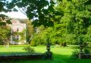
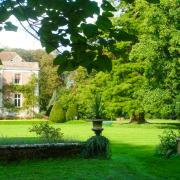
4. Turn left to pass Silton’s Manor Farmhouse, stone barns and ancient oak tree. Continue down the lane, past right Church Cottage, to Silton’s St. Nicholas’ Church. Go through the lych-gate to visit the church which dates to the 12th century, was rebuilt around 1500 and restored, with beautifully decorative wall and ceiling painting, in 1869. After viewing Sir Hugh Wyndham’s impressive memorial, return to the lych-gate. Go through the ‘Judge Wyndham’s Oak’ signed gates into the car park. Walk through and follow the grass path through young trees to the half-gate into the sloping field. Walk straight ahead, passing the solitary oak (the offspring of Judge Wyndham’s great oak) to the massive, and incredibly old, revered oak which could have been here when William the Conqueror landed. Sir Hugh was Justice of the Common Pleas under King Charles II for 13 years. After viewing, return to the lane and turn left. Back up the lane, pass Manor Farm, continue down sunken shady Bushes Hill and pass left Waterloo Lane at the bottom.
")
5. Keep straight on along hedged Pierston Fields Lane, passing the right turning signed ‘Whistley Farm and Whistley Waters’ and with fine farmland views. Pass left Pierston Manor Farm and cottages. Pierston Farmhouse was built in the late 18th century together with its adjacent original barn. Pass left, Whistley House and continue under large chestnut trees. Reaching the T-junction in Milton-On-Stour, The Old House on the right corner dates to the 17th century but was largely rebuilt in the 19th century. Inside, elements of ceiling beams, paneling and stone carvings were retained from the original building. Turn right and walk along the shady road. Pass a left footpath-sign and Dairy House and right Old Dairy’s drive.
6. Over the River Stour bridge with Milton Farm left, pass left Newlands Farm and Woolfields Farm. Past the left drive and opposite right turning, continue along the hedged lane to the next left gated track with corner footpath-signed 1½-gates and multiple arrows. Through into the field corner, cross diagonally on the clear path, then along the left hedge to a wide gap into the rough grass left field. Don’t go through. Go through the outside-corner footpath half-gate into the field corner. Walk up against the left hedge then bend slightly right to 1½ gates, signed back ‘Stour Valley Path 3½ Bourton’. Through walk to the gate onto Wavering Lane West, footpath-signed back. Through, turn left. Pass Slaughtergate Farm and continue ¼ mile back to the Stour bridge. Turn right onto Rolls Bridge nature park path returning to St Benedict’s Church.
Compass Points
Distance: 6 miles/9.5 km
Time: 4 hours
Start: St Benedict’s Catholic Church and Cemetery layby, Rolls Bridge Lane, Gillingham (Grid Ref: SY804268)
Exertion: Easy. Country lanes, gently sloping field paths
Map: OS Landranger Sheet 183
Public Transport: South West Coaches X2, X4 to Gillingham Station/High Street (short walk to St Benedict’s).
Dogs: On leads in lanes and near livestock abide by The Countryside Code
Refreshments: The Phoenix Inn or Rose Café, High Street, Gillingham