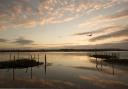
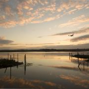
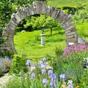
The great shingle bank of Chesil Beach extends north-west for 18 miles between Chiswell on Portland to West Bay. The Fleet tidal lagoon between the mainland and the beach starts at Small Mouth entrance from Portland Harbour and runs 8 miles to Abbotsbury Swannery where, now joined to the mainland, Chesil Beach continues to West Bay. Writer Monica Hutchings said of Abbotsbury: ‘the stone houses of the longish village street are reminiscent of Cornwall’. Many are thatched, and others overlook the opposite side from their elevated pavement. This fine, varied ramble starts by walking the length of West Street before turning down to Abbotsbury Sub-tropical Gardens. On reaching Chesil Beach, the route joins the South West Coast Path around Chapel Hill on which stands St Catherine’s Chapel. From the Swannery, a footpath leads up Linton Hill, which is less frequented than Chapel Hill but affords even better views, before descending to the Portesham road, and returning to Abbotsbury.
The Walk
")
1. Walk west along West Street noticing the variety of stone cottages. Pass right Red Lane opposite the village shop and Post Office. Pass left Ilchester Estate’s West Yard barn and garden centre with St Catherine’s Chapel behind. Leaving West Street, pass left-fork Town Lane and the 50mph signs. Then, at the left X52/X53 bus stop, take the ‘Ilchester Estate Permissive Path to Sub-Tropical Gardens’ off the road. Follow the enclosed grass path up along the field’s edge and over to the Gardens’ deer-fenced trees. Out onto the road, turn left. With the left stone wall and trees both sides, pass the car park right and the Gardens’ entrance left.
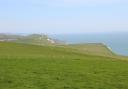
2. Continue down with Holm Oaks right and left. Pass a right footpath-gated track at the Abbotsbury Beach Car Park notice. Down the road, edged with tamarisk bushes, reach the left car park. Down further, go left into the car park to pass the café and the WCs. Before you continue into the far right corner (onto the South West Coast Path -SWCP), climb Chesil Beach for views north-west to Golden Cap and beyond and south-east to Portland. Now, into the car park’s far corner, pass the Coast Path notice advising about the diversion inland 150m ahead (to protect feeding birds). Through the bushes, walk along the shingle path, soon becoming grassier with tamarisk bushes then meeting the ‘Abbotsbury 1’, ‘Swannery 1¾’ Coast Path milestone.
")
3. Follow this fence-enclosed green track along the field’s edge and bending left with St Catherine’s Chapel ahead. Meeting a stream’s waterfall between two right gates, continue past the Permissive Path-stile by the second gate. Along the fenced track above the stream, notice strip lynchets on the left hill and also on Chapel Hill. After the stream crosses your track, reach the three-way signpost at right and left gates. Go over the right ‘Swannery ¾’ footpath-stile. Follow the walked path up along the right fence with left lynchets and right WWII pillbox with the Fleet’s closing end below. Walk up to the facing wall’s right-end ‘Coast Path Swannery and Abbotsbury’ ¾-gate. Through, follow the green path, passing a Coast Path-post and another pillbox with Linton Hill directly behind.
4. Still following your green track on Chapel Hill’s slopes, swinging slowly left, pass a left ‘St Catherine’s Chapel’ arrow-stone, then another left Coast Path stone for ‘Abbotsbury’ half-left, ‘Chapel’ left and ‘Swannery’ straight on. Walk straight down for ‘Swannery’ to the stone-wall’s unsigned half-gate. Through, continue downfield to the stile/footbridge. Over, follow the path past right buildings to the track’s three-way signpost. Turn right for ‘Swannery’. At the next signpost with car park left and Swannery entrance right, keep straight on, signed ‘Coast Path Weymouth and Ferrybridge 10¼’. Continue past another signpost and, at the Swannery signboard, join New Barn Road. Turn right down to Horsepool Farm’s right barns.
")
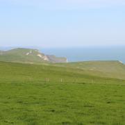
5. Walk up to the right bend with a barnyard left but go straight up the bank’s steps to the ‘Coast Path Ferrybridge 10’ footpath-stile. Over, turn left along the hedge to the elegant-stone stile in the corner. Over, turn right and climb the path right/left up to the SWCP-post. This is Linton Hill. Go right, up the ridge to another SWCP-post. Past this, keep straight up the windy ridge. Keeping to the right side, go over the fence’s step-stile onto the narrow path outside the field’s fence along Lipton Hill’s gorse-clad southern slope. Past the ‘Coast Path Ferrybridge 9¾’ post, continue for ¼ mile, viewing the Swannery and the Fleet’s end below. The path undulates with Clayhanger Farm cottage below-right. Reaching the milestone, Coast Path ‘Ferrybridge 9’ goes over the facing stile. You don’t!
6. Instead, for ‘Footpath’, go through the left unmarked gate into the rising field. Follow the right bank’s old stone wall up and over Linton Hill. Continue down the right bank then fenced pinewood and pass a footpath-arrow on a right gatepost. Keep going steeply down to the hedge-corner horse-jump (no arrows). Over this, walk down the hill to the bottom right bridleway-gate. Go through (backwards footpath arrow on the other side) and follow the shallow valley track up and round left with the B3157 behind the right hedge. Reaching the right gateway, go through and turn left along the verge. Past left Linton Cottage and the lay-by, cross to the right verge at the Abbotsbury village sign and 30mph post. Pass right Glebe Close and left Swan Inn. Cross back left and pass Village Car Park opposite Rosemary Lane. Continue down to the T-junction. Go left to visit St Nicholas’ Church and view Abbotsbury Abbey tithe barn and gatehouse remains, turn right into Market Street back to where you started.
Compass Points
Distance: 4½ miles/7.25 km
Time: 2½ hours
Exertion: Fairly easy
Start: Strangways Hall opposite Ilchester Arms (Grid Ref: SY576854)
Map: OS Landranger Sheet 194
Public Transport: First Jurassic Coast X52/X53 between Lyme Regis and Weymouth, except Sundays
Dogs: On leads near livestock, abide by The Countryside Code
Refreshments: The Old Schoolhouse Tea Rooms or Ilchester Arms in Abbotsbury