This circular walk leads you along a mile of the old Maiden Newton to Bridport railway branch line into the lovely village of Toller Porcorum which once had its own railway station. Then, a stroll over sheep fields, along a country lane, around a dairy farm and across Powerstock Common returns you back to the start.
After years of delays and issues - notably earth-slips at Wytherstone Cutting across Powerstock Common between Toller Porcorum and Powerstock - the Maiden Newton to Bridport branch line opened. The first train to run on the line started from Bridport at 8.15am on Thursday 12th November 1857. Five years later, Toller Porcorum opened its own station. By 1975, this route was Dorset’s last remaining branch line; it closed on 5th May, the last train having run two days earlier.
More than ten years ago, George Sartin instigated his plans to turn the Maiden Newton to Bridport branch line into a safe cycle route. At Toller Porcorum, a map and picture board, recognises the efforts of George, family members and volunteers on this project. When completed the Maiden Newton to Bridport Trailway will offer a 10-mile traffic-free path for the benefit of walkers, cyclists and wheelchair users.
")
The Walk
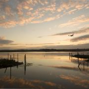
1. From the car park, walk down the lane. At the railway bridge, go up the right path onto the Maiden Newton to Bridport railway track. Follow this for one mile, elevated and meandering slightly at first above fields and woods with Toller Stream (which joins the River Hooke at Toller Porcorum) down to your left. Pass a left Nature Reserve gate and a shelter/bench facing the morning sun. Reaching a facing gate, the line straightens considerably, passing a left half-gate then between opposing gates opening right into a field and left into Nature Reserve trees. Keep straight on, passing a railway-post numbered 6 and 3, an old brick railway hut and a brick-parapet stream bridge. Then swinging slowly clockwise between fields, reach a gated footpath crossing. Go through 1½ facing gates, ascend a short left/right bend and continue above the right meadow.
")
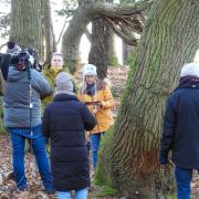
2. Pass newly planted trees left and a plaque to George Sartin who, with his family and volunteers, worked hard to create the Trailway by his 80th birthday, which the plaque recognises. Here, a footpath crosses our track, and a Permissive Path arrow points back along the railway line. However, continue above Toller Stream which is now in the right trees, and with Toller Porcorum church appearing forward-left. Bending left/right, join the signposted footpath coming from your left and continue onto the road. Notice the railway bridge to your right, then walk to the T-junction with the right telephone box. The green track from the telephone box was the lane to the railway station. Turn left into School Lane to visit the Church of St. Andrew and St. Peter. The chancel dates from the 13th-14th centuries. The nave was widened in late-14th century, and the building was restored in 1891 and 1895. Then return and follow the road over that railway bridge. Pass left Frogmore Lane and the thatched cottage, and right Old School House. Opposite right Number 9 cottage, take the left stepped footpath-stile.
3. Into the field corner, walk ¼-right up to the top corner footpath-stile and cattle trough. Over, walk slightly-right up and over the field to the two-way footpath-fork twin-stiles midway along the facing hedge. Over, go ¼-right diagonally up to the field’s top right corner unsigned gate. Through into the high field, continue towards the top right corner, clear of the right white house. Reaching the footpath-gate with ‘Frogmore Lane’ footpath signpost outside, go through onto the road bend with Toller Porcorum village sign down to your right and a woodland track on your left. Walk up the hill, passing Colesmoor Farm left fork footpath-drive. Continue up around the left/right bend and past a left gate, gently rising, hedged both sides and with super long views.
4. Past left twin footpath-gates and a right gate, continue over the high point with ‘Trinneys’ bungalow right and descend to the four-way signposted junction. Cross over into ‘Barrowlands Farm’ bridleway-signed drive. Follow the left hedged and right fenced drive, with distant hill views, to the Barrowlands Farm sign before any buildings. Although unsigned, take the right electric-fenced chalk track down, bending left/right/left below all of the buildings. Reaching the gate onto tracks from the left farm, go through and turn right down the ¼-mile long chalk track, wide and fenced, its muddy after prolonged rain. Down to the stream bridge, continue up the other side to a tracks’ fork. Bend left here and continue up to the end concrete cattle trough. Past this, keep straight on up to the bridleway half-gate in the hedge/coppice.
")
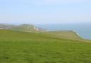
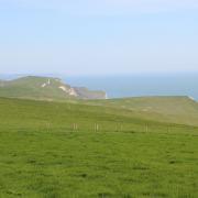
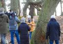
5. Through onto the right/left bridleway, you’re in Kingcombe National Nature Reserve (NNR) Powerstock Common with a distorted moss-covered, twisted tree left and an old Dorset Naturalists Trust ‘Dogs on Leash’ sign right. Go right, through bracken and blackberries (in season). Keep on the grass path above the left hill, from where there are long views to Pilsdon Pen, Lewesdon Hill and distant Charmouth, then becoming narrow and descending slowly into Wicker Coppice’s hazels and stunted oaks. Continue down, widening, and with the right bank and ditch marking the parish boundary with Powerstock this side and Toller Porcorum the other. Down to the facing bridleway ¾-gate, go through and continue to the track coming from the left gates. Turn right down the track, over the common and through scattered trees. Bend right at a left-joining track which leads to ¼ mile long Wytherstone cutting where the earth-slips caused so many problems for the line during its construction. Through 1½ gates, continue past left car park and information boards back to the car park where you started.
")
Compass Points
Distance: 4¼ miles/6.75 km
Time: 2½ hours
Exertion: Fairly easy. Two short ascents. Few stiles
Start: Kingcombe National Nature Reserve Powerstock Common car park (Grid Ref: SY547974)
Map: OS Landranger Sheet 194
Public Transport: None
Dogs: On leads in Nature Reserve and where requested, follow The Countryside Code
Refreshments: Chalk and Cheese, Maiden Newton, food avail Tues – Sat, dog friendly