Head to Ashurst for a peaceful walk in the New Forest National Park, taking in open common, woods and the Beaulieu River says Steve Davison
The New Forest, or the Nova Foresta as it was known in the Domesday Book, is a unique and captivating landscape of open heath and ancient woodland tucked into southwest Hampshire. ‘Created’ by William the Conqueror in 1079 as a royal hunting ground, the New Forest has, for the last 900 years, owed its very existence to the influence of man and his animals.
However, a walk in the depths of the forest takes you into a part of Southern Britain that William the Conqueror would probably still recognise. Couple that with the fleeting glimpses of wildlife – a deer suddenly stops to look before magically disappearing in the blink of an eye, birdsong mingles with the rustle of the wind in the trees, wildflowers add splashes of colour to the beauty of the enchanting woods, the commoners’ stock, including the iconic ponies, graze the land as they have done for centuries – and you have all the ingredients that make walking in the New Forest such a rewarding experience.
From Ashurst, the walk heads through Churchplace and Deerleap Inclosures following well-defined tracks before crossing a bridge over the London Waterloo to Weymouth railway. The line was originally opened by the Southampton and Dorchester Railway in 1847 and the local station, from where we started our walk, was known as Lyndhurst Road until it was renamed Ashurst (New Forest) in 1997.
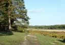
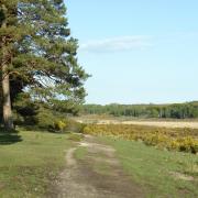
The paths become narrower now as they meander over open heath before passing through Matley Wood with its mix of oak and holly trees. Soon we leave the trees behind and head over open heath again to meet up with the Beaulieu River. The picturesque river rises near Lyndhurst and meanders for 12 miles through the eastern half of the forest, passing Beaulieu and Buckler’s Hard to join the Solent. The walk follows a lovely peaceful stretch of the river westwards to a bridge – a great place for a picnic lunch stop amid the tranquillity of the forest – before heading back to Ashurst, passing through a mix of woods and open heath.
Information:
• Distance: 5.25 miles (8.4km)
• Time: 2.5 hours without stops
• Terrain: Fairly level, good tracks and some narrow paths which can be muddy, some stiles and gates.
• Start/Finish: Ashurst (New Forest) railway station (SU334101) on the A35 between Lyndhurst and the junction with the A326 - car parking at the station or in the village.
• Map: OS Explorer OL22
• Refreshments: The Happy Cheese pub and the New Forest pub.
The walk:
1) (SU334101) - From Platform 2 at Ashurst (New Forest) railway station head north along the enclosed path parallel to the platform and bear right along the tarmac track towards the village (ignoring a gate on the right). If arriving by car, take the footbridge over the railway to access Platform 2 from the car park.
2) At the three-way junction, take the middle road, keeping The Happy Cheese pub on your left and the car park on the right. Keep ahead through a gate and follow the gravel track straight onto a junction.
3) Turn right and follow the gravel track south-westwards for a third of a mile through Churchplace Inclosure to a track junction. Turn left along the track (cycle track) for three-quarters of a mile, passing Church Place – site of a former royal hunting lodge – to reach a T-junction with another cycle track.
4) (SU346092) - Turn right and follow the cycle track for half a mile, keeping left at the Y-junction. At the next junction turn left and go through a gate to leave Deerleap Inclosure. Keep ahead for 25m to a junction where the cycle track turns left.
5) Here, we turn right and head past some trees to cross the railway bridge. Follow the track across Fulliford Bog and fork right at the split (straight on), heading for the trees in the distance and ignoring all crossing paths. Continue up through Matley Wood for a third of a mile and shortly before the low vehicle barrier at Matley Heath campsite, turn right beside a large old tree trunk.
6) (SU332076) - Follow the path (indistinct at times) heading north, down to the edge of the trees and a cross-path junction. Go straight on, following the path through the heather, and cross a footbridge in the trees.
7) Turn left to follow the north bank of the Beaulieu River through Longwater Lawn for a third of a mile to reach a footbridge – the small boundary stone marks the boundary of the Parish of Colbury – close to some trees.
8) (SU323087) - Don’t cross the bridge over the river - instead turn right, heading north-east away from the river, with woods over to the left and later a few oak and holly trees to the right. Keep straight on through the trees, ignoring a split to the left, to eventually reach a low vehicle barrier.
9) Cross straight over the surfaced driveway and continue towards the building in the distance. Cross the driveway for Ashurst campsite and then over a footbridge. Ahead is the New Forest pub. Head over to the far right corner of the field and through the gap to enter the station car park.