Steve Davison heads to the picturesque village of Steep for a walk through the Ashford Hangers
The little village of Steep has had a number of famous residents over the years, including the poet, Edward Thomas (1878-1917), who took inspiration for his poetry from the countryside around him.
Inside All Saints Church, which dates from the 12th century, there are two engraved windows by Laurence Whistler, dedicated to the well-loved poet.
After looking round the church, which also has some stained glass windows, Norman features and a shingle-clad spire, the walk sets out along the Hangers Way, a 21-mile route that meanders through the wooded countryside between Alton and the Queen Elizabeth Country Park - the name ‘Hanger’ comes from the Old English ‘hangra’ meaning a wooded slope, which is an apt description of the surrounding countryside.
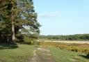
Soon the walk reaches Ashford Hangers National Nature Reserve, an enchanting area of woodland. Here the walk becomes a bit more strenuous as it winds its way up Wheatham Hill. At the top, take a short detour to the trig point, from where there is wonderful scenery, known as Cobbett’s View. The views were first noted in 1822 by William Cobbett when he rode through the area and subsequently published his ‘Rural Rides’...
“...out we came, all in a moment, at the very edge of the hanger! And never, in all my life, was I so surprised and so delighted!...it was like looking from the top of a castle down into the sea, except that the valley was land not water...”
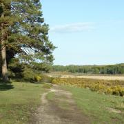
Follow the ridge to rejoin the Hangers Way at a seat on the Shoulder of Mutton Hill, from where there is another great view looking south towards the South Downs (off route, partway down the path straight ahead, is a memorial to Edward Thomas). Thomas refers to the hill in several of his poems, including in ‘When First’.
From this lofty position we follow the Hangers Way down into Lutcombe Bottom before heading back to Steep, passing The Cricketers Inn on the way.
The walk
• Distance: 4.5 miles (7.3km)
• Time: 2½ hours without stops
• Terrain: Steep up and down, tracks and paths which can be muddy, no stiles, some gates, sections of country road
• Start/Finish: All Saints Church, Steep (SU745253), just north of Petersfield; on-street parking near the church
• Map: OS Explorer 133
• Refreshment: The Cricketers Inn (01730 261035) at Steep
The walk
1 (SU745253) - Stand with your back to All Saints Church, cross over Church Road and pass a gate to enter a field. Head towards the left-hand corner and follow the Hangers Way through the trees. Emerge into a field where the path splits. Follow the left-hand path (Hangers Way), along two sides of the field before turning left through a kissing gate to join a lane (with Island Farm Lane opposite) and turn right. At the right-hand bend, go straight on along a narrow signed path beside the building, crossing a footbridge (small waterfall on left). Follow the path uphill, cross a footbridge, then up some steps to join a wider path. Turn left, soon passing Little Langley Conservation Area Viewing Point which overlooks a small pond.
2 (SU742259) - Follow the path, soon going right then left to join a tarmac drive (with The Waterhouse to the left). Turn right up the drive to a lane and turn right for 350m, passing some cottages before turning left on to a track, just before Poet’s Cottage. Keep ahead past the gate to enter Ashford Hangers NNR and keep right at the split, heading uphill. Ignore turnings to the left and follow the fence on the right (later, a gate on the right gives access to a seat and viewpoint). Continue steeply uphill to join a level track and turn left. After 100m, take a short detour right through a kissing gate and up a short rise to the trig point and seat on Wheatham Hill; enjoy Cobbett’s View before returning to the track and turning right.
3 (SU744271) - Follow the track straight on for 650m, ignoring a track to the left and right, to reach a Hangers Way sign for the Shoulder of Mutton Hill, here turn left to a seat. After admiring the view, ignore the path straight ahead, but turn right to follow the Hangers Way gently downhill for half a mile. At the junction, in Lutcombe Bottom, where the path starts to rise again, turn left and keep to the main route, passing to the right of a pond and then keeping the stream on the left, to a lane.
4 (SU737263) - Turn right for 450m to a junction with Island Farm Lane, bear right before turning left along the enclosed footpath. Keep to the path as it curves round the field and then go through a kissing gate. Keep ahead along the track past some garages. Turn right to the main road, then left to a crossroads beside The Cricketers. Turn left along Church Road back to the church.