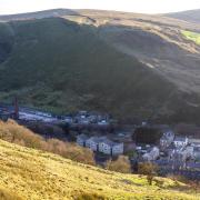
John Lenehan goes off the rails on a route through disused train tunnels in the Rossendale hills near Waterfoot
I was driving to a garden centre at Walsden and took the Bacup Road out of Waterfoot when I noticed two railway tunnels on the right of the road. One was blocked off but the other appeared to be open and of course my walking brain wondered what they were.
A quick search online revealed that the open tunnel and one further on had been made safe and opened up as a walking and cycling route. I decided to plan a circular route that included the tunnels and the 1444 foot/440 metre Cowpe Lowe Hill that dominates the skyline of Waterfoot.

The tunnels are actually bored through the northern flanks of the this so the walk is literally under and over the hill. Historically it is quite interesting as it mainly follows the route of the disused Rawtenstall to Bacup railway line for the first part and, on the second part it passes close to some of the many mainly disused quarries that provided the stone which built the towns and mills of Lancashire.
1. Walk back along Hill End Lane towards the main Bacup Road but once over the river bridge turn immediately right onto a track running parallel with the pavement. There is a sign saying ‘Alan Fishwick Way’. Simply keep following the obvious track for quite a distance. It narrows for a while uphill to reach a tarmac road. Cross the road and the track keeps on but is now called Rolling Boar Trail. Keep on this until it ends and turns sharp left and over a river bridge.
Cross the bridge and go through the covered gap between two industrial buildings. Take care as forklift trucks operate. Enter Holt Mill Road and follow this to the main road and turn right. Walk through the centre of Waterfoot and keep straight on past the roundabout along Bacup Road. Turn right into Cowpe Road and just before the bridge over the river turn left along a cobbled lane and pass a coal yard on the left.
Reach and cross a metal footbridge and enter the old railway tunnel. There is a blocked second tunnel on the right. Walk through the tunnel and then, after exiting, keep on the track and walk through a second longer tunnel. After exiting this look back and to the left there is a blocked tunnel. This tunnel runs parallel to the two open tunnels but curves deep into the hillside and is probably too long and would be too expensive be opened as a walk.
Note: The land the tunnels are bored through is called the Thrutch Gorge, or the Glen. They were called the Newchurch Tunnels built around 1852. The shorter one is Newchurch 1 and is 162 yards/148 metres long and the longer Newchurch 2 is 290 yards/265 metres. The blocked tunnel was built later and is called the Thrutch Tunnel and is 592 yards/541 metres.
2. After leaving the tunnel keep following the track until it reaches a road at an old iron railway bridge. Join the road and turn right, crossing the old iron bridge and follow the road steeply uphill then turn right onto Royds Road. There is a bridleway sign inconveniently hidden in the bushes. Follow Royds Road that eventually turns into a track and keep on this until it bends sharp left. At this point carry on to a metal gate with a blue bridleway sign near it.
Go through the gate and keeping a wire fence and ruined wall on the left go downhill to reach a stile. Go straight through the stile, there is a bridleway sign pointing right but ignore this and carry on going downhill on a very rough path with again the wire fence on the left to reach and cross a metal footbridge to join a road. Turn left then immediately right and follow the road then track uphill.

3. Go up the hill and there is a house facing called Cowpe Bottom House. Go through the gate and immediately turn right, there is a yellow footpath arrow, then turn left and go up a narrow path to reach a gate go through this to a stile and cross this then go uphill on a very rough path with a wire fence on the left to a ruined stile and pass this keeping uphill.
Reach a wooden gate stile and to the right of this is a metal gate. Go through the gate to join a track and turn left and follow the track uphill.
There is a sign saying ‘Pennine Bridleway’. Keep on the track, passing through a metal gate, and reach a sign saying ‘Tipple Farm Accommodation’ pointing right, ignore this and keep following the track as it goes sharp left and onto a metal gate and go through this.
The track splits but keep straight on do not go left and reach another gate with a stile to the left cross this and keep on the track going uphill. Reach a two way fingerpost one saying ‘Pendle Bridleway Top of Leach’ and the other saying ‘Waterfoot’ pointing down the track you have come up. Turn right and follow the wide track towards the obvious Cowpe Lowe and take a narrow path on the right going straight up the steep hillside.
Note: I have tried to find the meaning of Cowpe Lowe and have found Lowe means ‘near the small hill’ and from this I presume that there was a family called Cowpe living or owning land in the area, or near the hill.
4. Eventually reach the triangulation Pillar on the summit of Cowpe Lowe then take the path going left and follow this downhill to reach a track and turn right. A few metres along the track it splits and at this point keep right to reach a gate stile.
There is a sign saying ‘Rossendale Way’ and another saying ‘Rossendale Round the Hills’. Cross the stile then turn right and go slightly uphill to reach a path then turn left and follow the path. When the path splits going right uphill, keep left and follow the path downhill towards a small reservoir then keep to the left of this and join a wide track then turn right.
Go through two gate stiles and follow the track heading left towards a wind generator then bear right and follow the path downhill with a wall over to the left and pass between two stone gate posts to reach a track and turn sharp right and head downhill to a gate and stile to the right of a cottage. Join a track and follow this downhill and it eventually turns into Hill End Lane and leads back to the car.
Note: On the right as you pass the reservoir are three stone pillars and it is worth walking over to look at them. They are nine feet high and I believe they were built as memorial tributes to three residents of Cloughfold who had passed away.

COMPASS POINTS
Start and finish: Small Industrial Estate, Hill End Lane, Cloughfold near Rawtenstall.
Distance: 5.27 miles/8.48 km
Time: 3.5 hours
Map: OS Map OL21 South Pennines.
Terrain: Mainly good tracks and footpaths but good walking boots are best.
Facilities: Toilets at ASDA, Rawtenstall


