

Peter James of the Norfolk Ramblers guides us through three easy walks showing off different parts of the county.
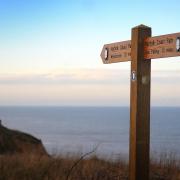
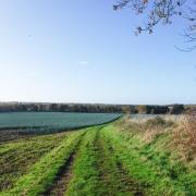
Weavers' Way
Park at Weavers' Way car park on Church Road opposite the farm entrance
Grid Reference TG2509 2869
Nearest postcode NR28 0LL
What3words /// flukes.counts.screen
Main walk 5 miles, 8km
Short walk 4 miles, 6.75km

(1) From the car park follow the track to the gate which you pass through to join the Weaver’s Way. Follow for 200 metres to the steps on the right. At the top of the steps, through the kissing gate, take the cross-field path to Nursery Lane; turn right then left. At the marker post take the cross-field path to the hedge; the path then bears right to bring you to a gap between the houses. Follow to the road, cross and take the road opposite. This brings you to Church Road. Turn left, passing the church to the corner at the main road.

(2) On the corner turn right at the finger post and follow the path to the end. Turn left, then turn right on the gravel track, passing Heath Farm. This will bring you onto Bryant’s Heath. Follow the path straight ahead, following the marker posts with the blue arrows. Where the track splits take the path uphill to the left and left again to follow the marker posts to the track. Turn right, follow the track to the end, bearing slightly left and taking the path between the two fields. At the marker post take the cross-field path straight ahead; at the next field boundary by the oak tree the path heads for the buildings ahead which is a leisure centre.

(3) Cross the road - the footpath is along the inside of the hedge in the car park. At the end of the car park turn right, passing along the drive to the bowling centre. Turn left through the second gap in the hedge beside the fence, follow the cross-field path to the corner of the field. Cross the road, turn right, follow the road past the sign for Weaver’s Way car park. Cross the road, passing through the gap beside the crossing gate. Follow to the next road - if you wish you can take the slightly shorter route, keeping straight on the Weavers Way.

(4) At the road turn left, follow the road to the point it turns right. Pass beside the metal barrier and carry straight along the path ahead. Just before the woods, at a marker post, turn right, following the path beside the woods. At the road cross straight over and follow the road. Just before the bridge take the steps up to re-join the Weavers Way. Turn left and follow this; you will come to the old station buildings and platform at the end of the platform turn right returning to the car park.

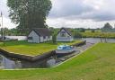
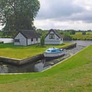
Sheringham Walk
Main Walk 6 miles 9.7km
Slightly shorter without the climb to the visitor centre 5 miles, 8km
Start from the esplanade boating lake
Grid Reference TG155 434
Post code NR26 8LE
what3words ///human.palaces.disbelief
The walk can also be started from the visitor centre at Sheringham Park
Grid ref: TG138 410
Post code NR26 8TL
what3words ///pausing.fund.hairstyle

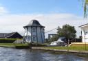
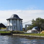
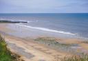
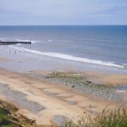
(1) From the boating lake take the path beside the golf course up to the lookout post on the top of the cliffs, where you have views over (A) Sheringham and Weybourne. From here you head down towards Weybourne; follow the path to a marker post. Turn left, crossing the north Norfolk railway. Before the road turn right then left, crossing the road to enter Sheringham Park. Follow round the field edge you will come to a seat( B) where there is the entrance to the steps up to the Gazebo where there are great views. If feeling energetic it is worth the climb, otherwise carry on along the field edge path to a gate on your left and follow the path with views of Sheringham Hall on your left.

(2) If taking the short walk go straight on to point (3). For the longer walk turn right following the path through the woods. Follow the signs for the visitor centre where there are toilets, refreshments and a gift shop, also an exhibition of the history of the park. You then retrace your steps back to the marker post off to the right. When you reach the viewing area head down the steps to the gate; you will see the gate to the temple. There are excellent views from here from the rear of the temple; head towards the fence at the back off the hotel following down to the drive.
(3) Pass through the gate, following the road down to Upper Sheringham. Go through the village, passing the church on your right. At the sharp bend carry on ahead to Cranfield Road, then go left at the finger post on to Butts Lane. Follow to the end, bringing you to the main A1082. Follow the road down to the roundabout, walk down the main street to the sea front. Turn left, following through to the signs for the toilets and boating lake from where you started.
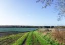
Alderford And Upgate Common
Park at Alderford Common car park
Grid Reference TG128 184
Nearest Postcode NR9 5NG
What3Words /// rapid.electrode.poetry
Main walk 6 miles 10km
Short walk 3.75 miles 6km

(1) From the car park entrance cross the road through the gap in the fence and cross the field towards the red brick cottage. At the field edge turn right and follow to a gap in the hedge; turn right onto the drive to the road and turn left. Carry straight on to the village sign and turn right. Just past the end of the playing field take the path to your left across the field. At the bottom of the field turn right before the bridge following the field edge which will bring you to Upgate.
(2) If doing the short walk cross the road and take the track between the houses to Reepham Road. Cross the road and follow a track to the steps up to the Marriott’s Way where you will re-join the main walk at (5).
If doing the main walk turn left across Upgate Common to take the path close to the building with a dovecote. Pass through the common closely following a stream on your left. On approach to a wooden bridge on your left, turn right and follow the main path as it winds through the trees to a junction of paths at the edge of the woods. Turn left towards the wooden gate and here turn right at the waymark to take the fenced path ahead of you. This path runs through trees and passes a poultry farm.
Note: There are many paths on the common. If you should get disorientated in the common and end up on the road, turn left following the road to the corner in front of the poultry farm at (3).
(3) At the road turn left in front of the poultry farm entrance and immediately take the Sandy Lane track on your left through the woods to the road. Cross the road and follow the path in the woods to a Y-junction. Turn right by the waymark and follow the wide track passing a large wood store. Keep on the track to the road, turn left and follow to a T-junction. Cross the road to join the Marriott’s Way.

(4) The Marriott’s Way is part of the old Midland and Northern Railway which ran from Norwich City Station to the towns and villages of north Norfolk. Turn right, and follow Marriott’s Way for a mile to (5).
(5) This is where the short walk re-joins the main walk on the Marriott’s Way. Continue on the Marriott’s Way where you will pass over a bridge. Then, after passing a metal sculpture, take the track on the left which turns back on itself to the bridge you just came over. Go left under the bridge taking the path across the field to the hedge then across the next field to the road passing a hard standing. Turn right past the houses. There is a fingerpost on your left for Winch’s Way and Alderford Common. The display board is worth a read and may prompt a visit to Swannington village after your walk. Follow the main path to a kissing gate and go straight on to steps down to the middle of Alderford Common. Continue on the path to another gate and keep on the path straight ahead. At the next junction take the path to the right back to the start.