

If ever there was a place that hid its light under a bushell it's Ixworth. It's an unassuming sort of place, just a few miles from the busy A14. But it has such a rich story to tell . . . starting with the Romans in Britain.
Ixworth today is an attractive, peaceful village with a lovely church, an intriguingly named pub, schools, a library and some shops. But things weren't always this quiet. The roaring A14 may bypass Ixworth today, but back in the day it was an important junction in the Roman road system of East Anglia, connecting the important town of Colchester with north Norfolk.
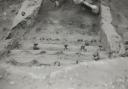
In the 1st century, the Romans built a fort here, probably to help fend off Boudicca and the Iceni people, who were putting up quite a bit of resistance to the Roman's presence in East Anglia. The remants of the fort are visible in three ditches which form sides of an enclosure. In 1834, excavation revealed the foundations of a Roman building with hypocaust, believed to be a villa and bath house complex.

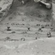
By the end of the century the Romans had left and Anglo-Saxons settled hamlets around the site of the fort. Among the archealogical finds in the area are an early pagan cemetery with Anglo-Saxon burial urns, and the Ixworth Cross, a gold pectoral cross covered in garnets dating from the 7th century, discovered in 1856 in what is believed to be another Anglo-Saxon cemetery. It was donated to the Ashmolean Museum, in Oxford, in 1909.
By the time of Edward the Confessor Ixworth had two main manors, extraordinary guive that the population, even by the 1086 Doomsday Book, was only about 50 people. Baron Robert Le Blund (or Blount) took over both manors, and his son Gilbert founded the Ixworth Augustinian Priory around 1100, which kept going until Dissolution in 1537.
Ixworth's first recorded name was in 1025 as 'Gyxeweorde', meaning 'enclosure of a man called Gisca'. The settlement was recorded in the Domesday Book as 'Icsewrda' or 'Giswortha'.The village's official website postulates that the modern name is probably a spoken corruption of the Saxon person Gycsa/Gisca.
"There isn’t really any evidence to suggest that the ‘Icks’ sound, common to Icklingham and Iceni, is anything more than coincidence," it says, "nor is there any evidence to suggest that the IX, Roman numerals for 9, suggests the 9th Legion or 9th district, which would, sadly, be a romantic but probably illogical connection." A lovely thought, though.

This walk traces some of the early days of Ixworth and takes in neighbouring Pakenham, where there are two mills, both in working order. This might seem like an embarrassment of riches, but not so long ago mills were everywhere in Suffolk and it was common for villages to support more than one. Thank goodness for the volunteers who keep the ones we still have turning.
The walk
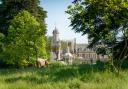
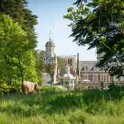
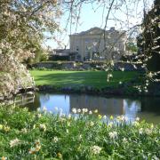
(S) Start at the village hall car park, a turning just off the high street opposite the church. Turn right onto to the high street, cross over in front of The Pykkerell Inn and head down Commister Lane (1). Pykkerell, by the way, is an old word for a young pike, and 'commister' is ancient slang for a clergyman, which is appropriate as around a bend are the grounds of where Ixworth Priory once stood. A graceful yellow house known as Ixworth Abbey stands there now, which incorporates some of the remains of the priory, including a Norman undercroft.
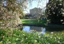
The path here is a causeway across what were probably the monks' fishponds originally. This was also Ixworth's 19th century 'Bathing Place', popular with villagers who used the various ponds for a spot of recreational bathing.

In July 1903 the Parish Council proposed paying a nominal rent of one shilling per year to the Abbey Estate for the use of Norton’s Hole for bathing - near Hempyard Bridge, which I'm about to cross - and even bought 30 yards of canvas to form a six-foot-high screen to protect the modesty of the bathers.
Across the bridge over the River Black Bourn I head straight on, past a small field to a small copse and follow the track around to the right. I'm in open country now, among fields of slowly emerging green, under an azure sky. It's still winter and puddles are frozen, but the weather has given me a glorious day. These are the joys of walking in west Suffolk - distant horizons and views as far as the eye can see, red kites and buzzards circling overhead, wide expanses of flinty fields punctuated by brooding woods and coverts.


I follow the track for about a kilometre to the end of a shrubby hedegrow and bear left onto a grass track (2). At the next corner I go left again across a ditch, then walk on for another 300 metres, towards a big metal field gate.
(3) I turn left onto a farm track - Heath Lane - and walk on, past Gameclose Covert. Ahead is a big farm reservoir, and a line of leafless poplars, skeletal against the cloudless sky, where a pair of red kites perch. Past the covert the views open up with Ixworth over to the left and Pakenham windmill on the low hill straight ahead. The track leads straight down towards the busy A143. I cross over and head up the hill opposite along Cutter's Lane.


At the top of the (gentle) hill I cross over a lane which follows the line of the Roman road that ran through Ixworth right up to the north Norfolk coast. In Thieves Lane, Pakenham windmill stands proud, a five-storey, black-painted tower, buttoned up the front with gleaming white windows, its sails still. The mill is a listed tower mill built in 1831 and owned by the Bryant family since 1885. P Bryant & Co still sell animal and pet foods ion site. The mill has survived storms and lightning strikes, and has been restored more than once, most recently in 2000. It's fully operational and open Monday to Friday 8.30am to 5.30pm, Saturdays 8.30am to 1pm.

Thieves Lane drops down to Fulmer Bridge, a picturesque spot with a lively stream, amidst woods and water meadows. I wander along this quiet lane called Broadway until I reach a T-junction (4) and turn left into Pakenham village. I go left again, following the watermill sign, passing tidy houses, a tiny Methodist cemetery, and Millers Meadow, behind whose decorative gates is an amazing menagerie of topiary sculptures.
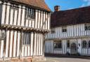
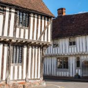
Pakenham Water Mill comes into view, its black and white frontage an imposing sight. On the other side of the road, water babbles into a pond where some topiary hippos and alligators keep guard. The mill is one of the oldest surviving mills still working in England, built around 1780, although there's been a mill on the site for over 1,000 years. It's owned by Suffolk Building Preservation Trust, originally set up by Suffolk Preservation Society to look after historic buildings in the county which it has acquired or been given.
You can visit the mill and see it working - check the website for opening times, which are seasonal (pakenhamwatermill.org.uk). There's a lovely tea room, and you can buy flour milled on site. On this walking day it's closed but I've made a mental note (on my ever growing list) to come back.


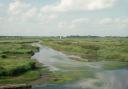
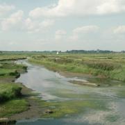
A little further along the lane on is Mickle Mere, a Suffolk Wildlife Trust reserve that happened by accident. It's 41 acres of wet meadows, open water and sedge fringed ditches are home to a rich variety of birdlife all year round. It lies in a valley next to the River Black Bourn, part of what were once grazing marshes that stretched from Elmswell to Euston on the Norfolk border. When the Ixworth bypass was built in the early 1990s a new sluice network connecting ditches to the river failed, resulting in regular floods that have become a wonderful wetland habitat.

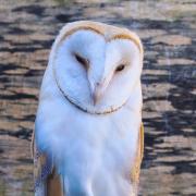
After a brief spell in the hide watching a variety of aquatic birdlife including swans, snipe, wigeon and godwits, I press on towards the A143 once again, passing Pakenham windmill across fields on the left. At the main road I go left reaching a white post about 50 metres along where I cross over. I go left along the path then turn right along the road back into Ixworth, passing a tiny white cottage that marks the tollgate that once stood at the entrance to the village. Back in the centre of the village, it's almost 1pm - possibly time to catch something tasty at the Pykkerell . . .

Compass points
Distance: 5miles/8km
Time: 2-2.5 hours
Start/finish: Ixworth village hall car park in the centre of Ixworth IP31 2HH
Getting there: A14, A1088 (junction 47); A143 from Bury St Edmunds
Access: Easy/moderate. Footpaths, bridleways, farm tracks, field edges, quiet lanes, crossing over A143
Map: OS Explorer 211 (Bury St Edmunds and Stowmarket) & 229 Thetford Forest in The Brecks)
Ts & Ps: in Ixworth