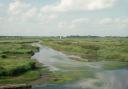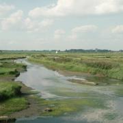

The peaceful, rural River Deben, winds its way through 25 miles of Suffolk countryside. The river is something of a Suffolk icon, carrying so much history of Saxons, Vikings, and boat building for medieval kings and more recent entrepreneurs.
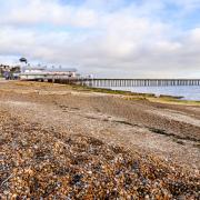
It passes through terrain that is pretty and flat – good walking country. The idea of this walk, along ‘The Deben Way’, is to follow the river as closely as possible from its trickling source above the village of Debenham to where it spills into the North Sea over a shifting shingle bar at Felixstowe.
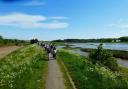
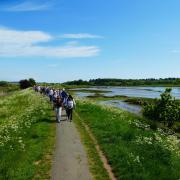
The route follows the non-tidal section can be split into four not too exhausting walks, or two longer trails; Debenham to Kettleburgh (10.5 miles), then onto Ufford (9 miles). They’re linear walks, so you’ll need a friend to pick you up at the end.
Part two starts half-way along The Street in Kettleburgh where you follow a track west past the village hall, crossing open fields to join up with a path along the southern edge of Sessions Wood.
As you follow a more confident Deben, reaching the crossing point of Sanctuary Bridge, you have the choice of turning left onto Letheringham Road with a great view of St Mary’s Church and what remains of the Augustinian Priory, or carrying on up the hill to take a track for a close-up view of the church. Either way you are heading for Letheringham with its pretty row of roadside cottages.
Past Homestead Farm and onto Potsford Wood, the path on the far side of the wood takes you to Dalinghoo Road and Wickham Market, where Rackham’s Mill, now a place to buy all types of fuel and other rural essentials, has been in business since 1885.
You are also close to the site of the Wickham Market Hoard, 840 Iron Age gold coins discovered in 2008 by Michael Dark using a metal detector. The hoard, dating from 40BC to 15AD, is believed to be the largest collection of its kind to be studied in its entirety.
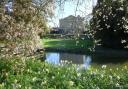
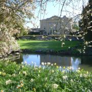
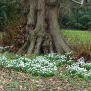
After Wickham Market, it’s back into open countryside and east to pick up the river again, with notable landmarks such as Ashe Abbey, another corn mill about three miles upriver from Woodbridge and Decoy Pond, where nuns dammed the river in two places for easier fishing. It’s a serene spot and a good place to stop and reflect if the weather is good.
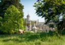
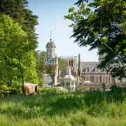
After Decoy Pond it’s on towards Loudham Hall, a fine Georgian Manor House set in 70 acres. When you reach the hall take time to gaze through the imposing metal gates. You might be lucky enough to spy a few ostriches. Reflect also on some of the Saxon jewellery which has been discovered by detectorists to your east on the other side of the river on Sir Michael Bunbury’s estate at Naunton Hall.
Now you have another choice. You can either follow the track across fields, heading directly south-west towards Ufford, keeping the Deben at a slight distance on your left. Or you can extend the walk by turning left after Loudham Hall, crossing over the railway line and following the Deben more closely back to St Mary’s Church, Ufford. You’ll cross peaceful meadows and pretty bridges, so if you can manage the extra mile, I’d recommend the latter.
As you complete the second leg of The Deben Way, it’s worth dropping into the church if it’s open and taking a look at the 15th century font cover. Made around 1450, it’s been called the most beautiful font cover in the world.
READ MORE: The route of the first of the River Deben walk from Micklefield to Kettleburgh
THE WALK

1. Starting in The Street Kettleburgh (Grid Ref TM 267 604) take the track that goes to the west past the village hall. After a short distance turn right onto a footpath that goes alongside a small wood before entering open fields. Ignore the path to your right when you reach the junction at the field boundary.
Follow the path around the south edge of Sessions Wood, then part way around the next wood, take the path on the right (south) to join the road. Turn left at the road for a short distance before turning right onto a path, walking alongside hedges around open fields to meet the River Deben.
Continue on the path, leaving the river after only a short distance, going alongside a hedge that will lead to a lane at the rear of Easton Farm Park. Turn right along the lane, reaching Sanctuary Bridge over the Deben, with a glorious view of St Mary’s Church, all that remains of an Augustinian Priory.

2. After crossing Sanctuary Bridge (Grid Ref TM 271 585) turn left towards the hamlet of Letheringham. You can access the beautiful little church down the track past Abbey Farm. Go through the pretty little hamlet and its mix of cottages, ignoring the road to the right. At the sharp left-hand bend take the footpath that continues straight ahead.
Follow the path alongside field boundaries and past Homestead Farm (left), until you reach the B1078 road. Turn left, taking care as you walk along the road for a short distance until finding the wide pathway at the entrance of Potsford Wood on your right.
Take the path as it follows the eastern edge of the wood. Not far after leaving the wood, at a path junction take the left-hand path, going across fields to reach Dallinghoo Road at Mountain’s Cottage. Turn left along the road into the centre of Wickham Market.

3. From the centre of Wickham Market (Grid Ref TM 301 557), turn south along High Street. At the War Memorial turn left into Chapel Lane, then go left again along Mill Lane and back into open countryside.
Reaching a crossroads, continue straight on along a road with height restrictions and pass underneath the A12 road, turning right immediately afterwards. The road gradually decreases and becomes an unmade track as it passes a few houses. Continue along this track until it becomes a pathway on the south side of a large hedgerow heading towards and under high voltage electricity cables.
Cross over drainage channels and, eventually, a small bridge over the River Deben where there is a path junction. Turn right and go along the hedge towards The Larches and Decoy Pond. Here the path becomes wider before reaching the road at yet another footbridge. Turn right along the small lane, passing Park Farm on your left. After some distance, you reach a gap in the hedge on the left signed and with a stile on the field side of the hedge.

4. Pass through the hedge and into the fields beyond before turning left to go along side a small wood that helps to screen Loudham Hall (Grid Ref TM 311 544). After a short distance you come to a large farm track. Turn right to pass in front of Loudham Hall.
At the end of the track follow the sign diagonally to the right, across a field to another track against field boundaries. Continue along the path adjacent to the trees, heading approximately a south-west. This path gradually expands to become a track before joining a small road on the outskirts of Ufford. Turn left along the road for a short distance, then left into a meadow opposite Spring Lane, just after a thatched cottage. Go diagonally across the meadow, then turn right over a small footbridge into a small lane at the rear of St Mary’s Church (Grid Ref TM 298 752). This marks the end of part two of The Deben Way walk. You can get to the main road either along Church Lane or through the churchyard to the lane.


COMPASS POINTS
Kettleburgh to Ufford
Distance: approximately 14.6 km or 9.1 miles
Time: approximately 4 hours+
Access: footpaths, minor roads and lanes, field edges, stiles, footbridges
Start/parking: Kettleburgh (Grid Ref TM 267 604)
Map: OS Explorer 212 Woodbridge & Saxmundham
Ts & Ps: Wickham Market (Tea Pot Room; Café 46) Ufford (Ufford Crown, Ufford White Lion)