
You can meander along all 185 miles of the Thames Path from Greenwich in London to a field somewhere in Gloucestershire. If you’re Joanna Lumley you can show viewers the Nile in style, all 4,132 miles of it. But what about something more local, more manageable and, arguably, more walkable? (No camels on this journey.)
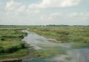
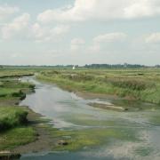
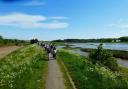
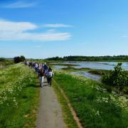
The peaceful River Deben, which winds its way through 25 miles of Suffolk countryside, fits the bill perfectly. The terrain is pretty and flat, the river itself is steeped in history (Saxons, Vikings, boat builders et al) and the route can be split into four not too exhausting walks, or two longer trails if you’re feeling fit and energetic. Let’s be bold and call it The Deben Way.
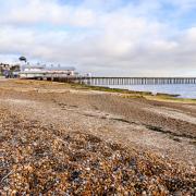
The idea of The Deben Way is to follow the river as closely as you can, from its trickling source above the village of Debenham to where it spills into the North Sea over a shifting shingle bar at Felixstowe. This article covers the non-tidal section of the river, two walks or one, from Debenham to Kettleburgh (10.5 miles) and then onto Ufford, (9 miles).

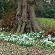
The first leg starts about a mile north of Mickfield on the road to Brockford to the west of Debenham. You will need a kind person to drop off you and any walking chums as you set out on your quest for a first glimpse of the Deben (and pick you up at Kettleburgh). Follow the footpath sign and walk east to the seasonally very pretty Mickfield Meadow and Nature Reserve. Spring is a good time but any non rainy day will give you a sense of tranquillity in these pre-Deben uplands. The meadow is rich in wild flowers, as it has never been sprayed or fertilised.
Continue to head north along the field edges and then turn right to join Stony Lane, about two miles long and reputedly the longest ford in the country. Away from those first trickily culverts, you could say this is the start of the Deben proper. Stony Lane can be a lazy trickle or a gushing torrent, depending on the time of year. If it’s dry you can walk along the stony bed of the ford, while there's a path above if it’s too wet. Look out for the Groaning Stone, a smooth riverbed rock which is said to turn over and groan at midnight when the moon is full.
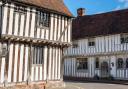
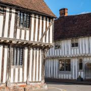
Continue along this dramatic section of the early river until you reach Derrybrook Farm, then press on to the Aspall Road where you turn right towards the centre of Debenham. Full of pretty period houses and quaint shops, it's more like a small town than a village, but village it is.
At Water Lane (the clue is in the name) you can carry on following the river by turning left. The clay soil above Debenham has, historically, left the village vulnerable to flooding. Statistics confirm that summers and winters are getting wetter and that rainfall can be more intense. In fact six of the 10 wettest years have occurred since 1998. Old records in the University of Oxford’s Bodleian Library hint at a more fulsome upstream Deben, with a note that 'ships of considerable burthen came up to the Town…'
Floods aside, there’s a great café for refreshments at the end of Priory Lane before you head south towards the village of Cretingham. Note the river on your right as it wanders bashfully through water meadows, keeping you company as you turn right and then left, following field boundaries to Potash Farm. Turn right at the main road and then left, passing an old outbuilding, crossing a field into woods before reaching the road. Then on you go following the course of the river to the rolling greens and wild edges of Cretingham Golf Club.
Feel relief perhaps that there is no need to stop for a nervous swing as you pass golf club buildings and keep going past streams and tributaries of the main Deben and on to Kiln Wood. Now head for Brandeston and stride rather than wriggle along Wriggle Street to the centre of the village. Enjoy the village sign with its surreal mosaic of a Viking ship and further downstream there’s Brandeston ford, an idyllic spot where cattle and other animals can cross the river. Nearby, hidden in the undergrowth, is what locals claim to be a smuggler’s hole, used for hiding contraband such as tobacco and brandy.
On you go through Brandeston, straight on past the village sign near the popular Brandeston Queen, staying on Low Street to get back into the countryside. There’s the Deben still lurking to your right as you head for The Street, Kettleburgh and the end of this first leg of The Deben Way. Time to take a deep breath and ideally enjoy refreshments as you wait for your lift or press on for the second leg towards Ufford. Whether you carry straight on or wait to walk another day you have a treat in store.

The walk
1. Start on Mickfield to Brockford road (Grid Ref TM 140 629) where the footpath sign leads to the east away from the road towards Greenwood Farm before following field boundaries to the rear of Mickfield Meadow Nature Reserve. Head north along the field edges, reaching a junction of pathways. Turn right to join Stony Lane and the course of one of the sources of the River Deben. Continue along the riverside through the woods until reaching the far side of Derrybrook Farm, join the larger path that leads onto a road that will bring you to the junction with Aspall Road. As you pass along The Butts you cross over another of the River Deben sources as it descends from the orchards around Aspall.
2. At Aspall Road, Debenham (Grid Ref TM 173 638) turn right towards the town centre. At Water Lane, follow the river by turning left. At the road junction turn right along Priory Lane and cross over the river again. Reaching the end of Priory Lane, turn left towards Kenton, until the next road junction. Take a right turn towards Ashfield. The river runs in through the water meadows on the right between the road and town. Continue along Thorpe Lane towards Ashfield, leaving Debenham behind. The river continues on your right. Eventually, arrive at a track with a fingerpost footpath sign.
3. Leave Thorpe Lane for footpath (Grid Ref TM 187 622). Turn right along the track and over the small water course that is the River Deben. Remain on the farm track as it gradually rises above the river to give beautiful views of the Mid-Suffolk countryside. Where the track comes to a T-junction, turn left and follow another track with views across Malthouse Farm and the river below. Just after passing Malthouse Farm the path forks; take the left fork and pass through a small wood. Follow the field boundaries until the path takes a right-hand turn towards Potash Farm then pass through the farm.
Reaching the A1122 Stowmarket-Yoxford road, turn right, then left after passing the old outbuilding. Follow the hedge until reaching an open field, cross the field into the woods and follow the path to the right. On exiting the wood follow the field boundary until reaching the road.
4. Join the Cretingham to Ashield road (Grid Ref TM 210 609), turn right and again follow the course of the river as it gently winds down the valley, now on your right, towards Cretingham. At the road junction into the village continue straight and go along the driveway into the golf club. Pass the club buildings, then go directly across the course to woods and streams that are tributaries of the main River Deben. After the woods pass through a couple of fields, then along a path across the north side of Kiln Wood. Just after the wood you will see the road after a stile in the hedgerow.
5. Climb the stile, turn right along the road, passing the intriguingly name Wriggle Street (Grid Ref TM 242 608) heading into the centre of Brandeston village. Pass through the village, continue straight at the junction with the village sign, near The Queen public house, remaining on Low Street at the junction, then heading into countryside. Ignore the first path on your left near Brook Farm, continue to the second path on your left, opposite the second entrance to Home Farm. Take the path through the wood, then at the end of the field turn right into the village of Kettleburgh, passing St Andrew’s Church on your left. Take the footpath that forks right opposite the church that will bring you to The Street.
6. On reaching the centre of this small village (Grid Ref TM 267 604) you have completed the first part of the River Deben Walk.
 OS Explorer")
Compass points
Distance: approximately 16.8 km or 10.5 miles
Time: 4+ hours
Start: Mickfield (Grid Ref TM 140 629)
Finish: Kettleburgh (Grid Ref TM 267 604)
Access: signed footpaths, roads, field edges, woodland, stile
Maps: OS Explorer 211 & 212
Ts & Ps: Pubs at Debenham, Cretingham, Brandeston, Kettleburgh