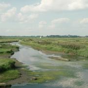


Shingle Street is an enigma. Its name alone is puzzling, a distinctly urban moniker for the little beachside hamlet at the mouth of the River Ore that's one of the most isolated spots in the county.
Originally it was home to fishermen, coastguards and river pilots; now it's a mix of permanent dwellers and holidaymakers. It's not that isolated, of course, not physically anyway, just four miles from the nearest village. Yet stand on the shore, hear nothing but the wind in your ears and the shingle shifting with the tide, and it feels like you could be the only person left on the planet.
It was deserted in 1940, when Britain was at war with Germany and the people living there were evacuated for fear of invasion by the Germans. Landmines were laid on the beach, bolstering the concrete tank traps strung out along the Suffolk coast.
The secrecy of it all fuelled the rumour mill. It was said a small German invasion force had landed at Shingle Street and a battle had broken out. The invaders were driven back and the sea was ablaze, the Germans burnt alive with oil and petrol pumped on to the surface using special pipelines.
With no one living there at the time there were no eyewitness reports, but so feverish was the speculation that questions were asked in the House of Commons. And it never went away. Fifty years later, in the summer of 1992, a Ministry of Home Security dossier detailing the 'Evacuation of civil population from the village of Shingle Street in east Suffolk' was released by the Government, following pressure from people keen to know what it said. File HO 207/1175 had not been due to be made public until 2021.
The papers confirmed the ‘invasion’ was just a rumour, although the bodies of four dead German airmen were washed up on the beach, after their plane crashed into the North Sea. They talked about the military requisitioning of more than 20 homes at Shingle Street, about plans to lay mines on the beach and to use the area for bombing test runs. But they revealed nothing about flaming seas, a thwarted Nazi invasion or burnt bodies on the shingle.
However, like most rumours, it refuses to go away and people still debate what really went on at Shingle Street, if indeed anything did. For me, in this month of Remembrance, Shingle Street serves to remind us of just how vulnerable the east coast has always been to malign forces venturing across the inhospitable North Sea, eager to claim us for their own.
From the beach you can look north and see the outline of the wartime structures on Orford Ness, and the shape of 12th century Orford Castle a little way inland. And there are three Martello towers in and around Shingle Street, built in the early19th century as part of a chain along the English coast against another potential invader, Napoleon.
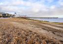
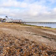
Now, though, Shingle Street is incredibly peaceful, a favourite place to come for sea swimmers, fishermen, kite surfers, photographers and wildlife watchers. And walkers, of course.
The walk
When you get to Shingle Street, there's a small car park just off the road, near the coastguard cottages. The walk starts at the Martello tower, so head off towards it either along the beach (honestly, walking on shingle is good for the thighs) or thread your way along the path in front of the houses. This is the Suffolk Coast Path that stretches all the way from Lowestoft to Felixstowe.

1. At the Martello tower, leave the beach and go along the fenced path. Find the turning off to the right where the path goes behind some beach houses and opens out into grazing marsh.

2. Head towards the flood bank where it's crossed by telephone cables, climb to the top of the bank and turn left, heading south. On your left you'll see Second World War defences on the marshes, the concrete tank traps that were placed all along the coast to foil – or at least delay – any invading force.
On your right, you'll pass another Martello tower with a wartime machine gun emplacement of the roof. Many Martellos have been converted into homes, but this one is disused and deserted.

3. Ahead lies a third Martello tower; about half way between the two you reach a sign pointing right to a path inland. Drop down off the embankment onto a track; cross over and walk away from the embankment along a field edge.
4. Keep walking until you turn the corner of the field and find a small wooden bridge crossing a ditch. Cross over and turn left along the path heading towards a collection of houses on a low hill in the distance. It's pleasant, easy walking through open fields for a couple of kilometres. When you meet a track carry on up a gentle hill with a hedge on your right. The path takes you behind the neat houses of Alderton and past the recreation ground on your right.
5. When you reach the centre of the village there's a handy shop where you can buy a drink, before turning right along Hollesley Road, passing neat houses and gardens.

6. After about 600 metres (watch out for farm vehicles), there's a turning on your right to Buckanay Farm. An easy stroll takes you past cottages, before bending round to the left and pressing on for about 2km. Just before you reach some farm buildings, on the left is a disused sand pit, the nesting place of sand martins which have drilled numerous holes. When I came across it, two fold-up chairs were perfectly placed to watch the action. The sand martins have left for warmer winter climes, of course, but I couldn't help thinking what brilliant summer evening entertainment they must provide.

7. When you reach the embankment again, climb up and turn back towards the hamlet. Retrace your steps across the grazing marsh and around the Martello, to the coastguard cottages and then the car park.
Before you go... on the beach you may come across another modern feature for which Shingle Street has become known. In 2005, stonecutter Lida Cardozo Kindersley and her childhood friend Els Bottema started to create a line of shells on the beach, a sort of 'life line' as a way of coping with their shared experience of cancer treatment. After regular visits to add to the line, by 2018 it was more than 275metres and was made up of an estimated 20,000 whelk shells. A short documentary film about the work, entitled 'C shells', was released in 2017, followed by a book, The Shingle Street Shell Line, in 2018.

Compass points
Distance: approx. 4.5 miles/7.2km
Time: 2 hours
Parking: Shingle Street off road car park
Start: Coastguard cottages, then Martello tower
Access: shingle beach, grassy paths, field edges, roads
Dogs: on the lead around the hamlet and in Alderton
Map: OS Explorer 197 Ipswich, Felixstowe & Harwich
Ts & Ps: Alderton (shop), Swan pub