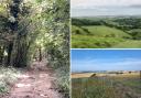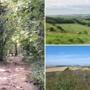

We’re dreaming of a white Christmas so we can take a frosty stroll in the snow that ends in a cosy country pub. Here we pick out half-a-dozen of our favourite walks from across the county – perfect for helping the turkey go down.
 Fiona Barltrop")
Alfriston – George Inn
Situated in the Cuckmere valley at the eastern end of the South Downs, Alfriston is one of the most picturesque of all Sussex villages. There’s beautiful open downland either side – the South Downs Way goes through the village – affording wonderful views from on top, while the Cuckmere Valley offers gentle walking along its banks.
The flint stone and half-timbered 14th century George Inn, one of a number of fine old buildings in the village, was first licensed in 1397. The foundations date back to 1250. In the past it was an important smuggling inn. The bar, the oldest part of the inn, has an impressive inglenook fireplace with a huge copper hood, oak floors and Sussex hop bines decorating the walls. There are also five bedrooms and a walled garden with views to the South Downs. The kitchen is open for both lunch and dinner.
Work up an appetite with a climb up and over Windover Hill – a superb viewpoint – to the edge of the woods above Jevington. Then head back westwards across Lullington Heath National Nature Reserve, passing Winchester’s Pond and forking right thereafter back down towards Alfriston. An invigorating 6-mile circuit.
Start/parking: Willows long stay car park, Alfriston, BN26 5UQ, grid ref TQ521033
Pub: George Inn (01323 870319), thegeorge-alfriston.com
 Fiona Barltrop")
Plumpton – Half Moon
Nestling at the foot of the South Downs, the Half Moon at Plumpton, with its big pub garden at the back, is well situated for walkers. There’s both a bridleway opposite and a nearby footpath that lead directly to the top of the ridge and the South Downs Way. The former is known as Plumpton Bostall, bostal (spelt with one or two ‘l’s) being a Sussex dialect word for the steep, old and often sunken tracks or paths climbing the escarpment of the South Downs.
For a good hour’s leg-stretch before tucking into some tasty festive fare, head up the Bostall and turn left along Plumpton Plain enjoying fine views both north over the Weald and south towards the coast. At the gate, turn left and soon left again down the woodland footpath, then head diagonally across a couple of fields to the B2116. A roadside path on the left leads you back to the pub.
For a longer 5-mile option, turn right at the top of the Bostall to Ditchling Beacon and retrace steps continuing along Plumpton Plain, or loop south via St Mary’s Farm. If you’d prefer to leave the car at home – and enjoy a relaxed drink or two - there’s a bus stop right outside the pub, or you could walk from Plumpton Station, a couple of miles to the north (follow the path beside the race course south to the Agricultural College, then across the field to the Half Moon).
Start/parking Layby in Plumpton Lane, grid ref TQ365133 (alternatively, if patronising the Half Moon, you can use its car park; the entrance is right by the layby).
Pub: Half Moon, Plumpton (01273 890253), thehalfmoonplumpton.co.uk
 Fiona Barltrop")
West Hoathly – Cat Inn
Set in the High Weald Area of Outstanding Natural Beauty and on the route of the High Weald Landscape Trail, the attractive village of West Hoathly – the highest point on the trail at 600ft/183m - makes a good base for exploring the surrounding countryside. Among its various medieval buildings is the Priest House, a 15th century timber-framed Wealden hall house-cum-museum (open March – Oct).
The Cat Inn is a 16th century free house with oak beams and two inglenook fireplaces providing a warm and cosy atmosphere in winter. The pub concentrates on local breweries such as Harvey’s of Lewes, and also offers an extensive wine list. Fresh, seasonal and locally sourced produce is used as much as possible. It has appeared in a number of guides over the years, including this year’s Good Hotel Guide, in which it is nominated as one of the UK’s best gastro pubs-with-rooms.
For a 4 - 5-mile circuit, follow the High Weald Landscape Trail (HWLT) north past Gravetye Manor, an Elizabethan manor house hotel & restaurant, then loop round back through Giffard’s Wood. To extend the walk a little, go under the Bluebell Railway line and head through the Kingscote Estate & Vineyard. Rejoin the HWLT towards Stone Hill House to view the Stone Hill Rocks (sandstone), used by climbers, then retrace steps, staying on the HWLT, this time crossing over the Bluebell Railway line.
Start/parking Finche Field car park, Church Hill, RH19 4PN, grid ref TQ366325
Pub: Cat Inn (01342 810369), catinn.co.uk
 Fiona Barltrop")
Fulking – Shepherd & Dog
The popular Shepherd & Dog pub sits at the foot of the South Downs in the village of Fulking. The award-winning walker and dog-friendly pub has a lovely garden with the Downs as the backdrop, and serves a variety of locally produced Downlands Brewery ales, as well as excellent food. Next to the pub is a spring and pump house, which contains a hydraulic ram pump. This was used in the past to provide the village with its own piped water supply until mains water arrived in 1951 – an information panel tells you more about it.
Facing the pub, head up the track to the left of it and in a few paces turn right, up steps, to follow a footpath that heads up the Downs. At a multi-path intersection turn sharp right to continue up to the top of the Downs, joining the South Downs Way. There’s excellent walking to be had in both directions following it along the top of the undulating ridge. Heading east takes you to Devil’s Dyke, renowned for its magnificent views and its great valley (dyke). Follow the ramparts round the top of the hill then return to Fulking by descending the bridleway that angles north-west down the slope (about a 3-mile walk).
Start/parking: Roadside parking just west of Shepherd & Dog car park, Fulking BN5 9LU, grid ref TQ246113
Pub: Shepherd & Dog (01273 857382), shepherdanddogpub.co.uk
 Fiona Barltrop")
Fulking – Shepherd & Dog
Ideally located for walks alongside the adjoining Wey & Arun Canal, the recently refurbished Onslow Arms is a 17th century, grade II listed building with oak beams, wooden floors and roaring log fires. Winner in the ‘Best Pub for Families’ category in the 2021 Great British Pub Awards, it serves a variety of delicious freshly-prepared meals including its own smokehouse specials, plus fine wines and Badger Ales.
Fifty years ago, a group of enthusiasts formed the Wey & Arun Canal Society, which later became the Wey & Arun Canal Trust, with the ambitious aim of restoring a 23-mile stretch of canal, which once linked the rivers Wey and Arun, which in turn linked London (via the Thames) with the south coast. Boat trips run from spring to autumn along the navigable miles of the Loxwood section, and canoes, kayaks and paddleboards are also welcome. Walkers can enjoy the canal by following the Wey-South Path, a long-distance path from Guildford to Amberley, that runs beside the canal wherever possible. For a pleasant 3-mile circuit, from the Canal Centre follow the towpath east to Drungewick Lane, turn left, then left again along a path through woodland to return to the start. A similar length loop can also be made by following the towpath in the other direction.
Start/parking: Car park for canal visitors beyond Onslow Arms car park and Canal Centre, RH14 0RD, grid ref TQ042311
Pub: Onslow Arms (01403 752022), onslowarmsloxwood.com
 Fiona Barltrop")
Charlton – The Fox Goes Free
The village of Charlton lies in the Lavant valley just north of Goodwood racecourse. Small though it may be, in the past it was famous for its hunt, established in the 17th century - there’s an impressive brick building called Fox Hall which was built in 1731 by the second Duke of Richmond as his hunting lodge. Restored by the Landmark Trust, it is now let as holiday accommodation. The 400-year-old highly-rated pub was once known as The Fox at Charlton, but on becoming a free house in 1985, appropriately enough changed its name to the Fox Goes Free. Charlton is also notable for being the venue of the first WI meeting in England, held on 9 November 1915 in the pub. You can look forward to some excellent cuisine, real ales and fine wine after enjoying a walk around the area.
For an easy 3½-mile triangular circuit, head south along Chalk Road past Fox Hall, continuing up the bridleway to the road near Counter’s Gate car park (alternative start), then follow the Monarch’s Way down to East Dean and return along the lane. If you’d like to extend the walk, the acclaimed Weald & Downland Museum at Singleton is just a mile away along a field path to the west (return the same way).
Start/parking: Considerate roadside parking in village, PO18 0HU, grid ref SU889130
Pub: The Fox Goes Free (01243 811461), thefoxgoesfree.com