A walk at Whitechurch Canonicorum taking in the well and shrine of St Wite, Dorset’s patron saint.
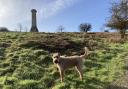
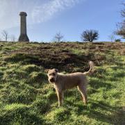
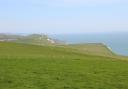
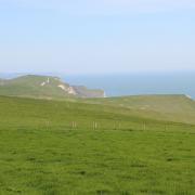
On the edge of the Marshwood Vale lies Whitchurch Canonicorum. The latter part of its name recalls the time when the annual levy on parish profits from land and stock were shared between the Canons of Salisbury and Wells. Looking over this village is Hardown Hill, 206-metres above sea level, it offers fabulous views over Morcombelake to Golden Cap on the Jurassic Coast, over Chideock to Thorncombe Beacon, and beyond Stonebarrow Hill to Charmouth and Lyme Regis. On Hardown Hill are nine eroded round barrows, one disc barrow and eight bowl barrows. A Saxon burial, discovered in 1916 in one of the bowl barrows, contained spearheads, axe heads and a brooch.
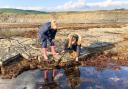
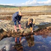
Dorset’s county flag features the white cross of St Wite (pronounced Wheater); the red edges reflect England’s cross of St George, and the gold symbolises Dorset’s agricultural heritage and golden beaches. We begin this informative walk by visiting St Wite’s Well, the waters of which are ‘considered to have curative properties for eye complaints’, located in a field below Chardown Hill south of Morcombelake. We then ascend Hardown Hill, north of Morcombelake. If this results in aching limbs, seek the healing help of St Wite (St Candida in Latin) at her shrine in Whitchurch Canonicorum’s Church of St Candida and Holy Cross. There are only two churches in England which, after the Reformation, still possess shrines containing relics of their own saints. One is Westminster Abbey, the resting place of St Edward the Confessor, the other is at this church in Whitchurch Canonicorum with its shrine to Dorset’s patron saint.
St Candida’s is one of Dorset’s prettiest churches. Built in the 12th century on the site of the original 9th-century church, remaining portions of that 12th-century building are the north and south transepts, the chancel and three bays of the nave’s south aisle. St Wite’s statue, in a niche outside the 15th-century tower’s south wall, is modern. Inside, the north transept houses St Wite’s 13th-century shrine; a plain stone chest with Purbeck marble lid with three pointed-oval openings in its front elevation.
St Wite is said to have been an Anglo-Saxon holy woman who lived on the cliffs, she was murdered during a Vikings raid on Charmouth. Her relics, contained in the shrine, are believed to have healing powers and still draw pilgrims from far and wide. Into one of the shrine’s three oval openings, pilgrims place their diseased or injured arms or feet (or a possession of somebody too ill to make the pilgrimage) as close to the saint’s relics as possible. In 1900, credence to her legend was enhanced when, during repairs made necessary by settlement of the building’s foundations, the shrine’s existing fracture opened, revealing a lead casket. The lid was inscribed: ‘Hic requiescit relique Sancte Wite’ (Here rest the remains of St Wite). When opened, it was found to contain bones of a small woman of about 40 years old. St Wite’s Feast Day, also known as Dorset Day, is celebrated on June 1st.
")
The Walk
1. St Gabriel’s Chapel, built in 1841, contains the 13th-century font from the former chapel of Stanton St Gabriell. From here, walk west passing right Gibbs Lane, left bus-stop and pedestrian crossing. Take left Ship Knapp lane. Walk up past the left Georgian house with a mansard roof. In a few yards, fork left onto the ‘St Wite’s Well 1’ track (it’s actually only ¼ mile). Follow the hedged track to a right house and into the field with Chardown Hill right. St Wite’s Well is inside the right fenced enclosure on the sweeping bend. After visiting, return to the A35. Turn right, cross the pedestrian crossing and take Verriotts Lane at St Gabriel’s Cottage. Walk up the steep banked lane, bending right up to Gibbs Lane T-junction.
")
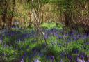
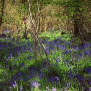
2. Cross into the footpath-signed stony track, climbing into trees. Past the National Trust (NT) ‘Hardown Hill’ sign, emerge into the clear track on Hardown Hill with fine views behind from Thorncombe Beacon and Golden Cap to Lyme Regis. Gradually swinging anti-clockwise, pass a left gate and right pine wood and bench. Keep straight on over Hardown Hill’s heather moorland. When the track bends left towards the phone-mast, walk straight on into the lesser track, still crossing moorland before descending into trees. At the NT ‘Hardown Hill’ signed T-junction, turn right at the footpath-arrow post. Down past a left gate, continue to Bluebell Wood Cottage and the road. Turn left down the hill, past left cottages with lovely views right, then sunken into Ryall. Pass the right-fork ‘Private’ lane, Lower Lane and Butt Lane.
")
3. Past Hope Cottage on the right corner, turn down right ‘Beerland Farm’ signed lane. Past left Ryall Bridport Reservoir, continue down and past the right bungalow. At the right farmhouse, take the left footpath-arrowed fence gap/stile. Over, walk diagonally right downfield. Ignoring the facing fence-gate, go over the stile into the new wood. Keep on down the path to the corner wooden gate. Through onto the green track with left Holly Farm’s camping field, continue on gravel track through a footpath-gate and straight on. Passing the right turn, continue between paddocks, then straight on grass again to the right corner footpath-stile. On to the road, go left and instant right into Griddleshay Farm’s drive.
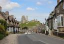
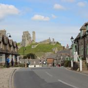
4. Before the gateway, go over the left footpath-stile. Follow the path, with left stream and right fence, to a kissing-gate. Through into the field, follow left trees to the footpath-gate. Through, follow left trees to another footpath-gate. Through, pass the left bridleway-gate and continue along left trees to a multi-arrowed stile. Over, turn right along the shady path past left allotments to the east gate of St Candida and Holy Cross Church. After your visit, return to this gate. Follow the path past the stile where you arrived and continue up to the end with ‘Mandeville Stoke Bridleway’ sign-posted left. Into Higher Street’s bend, continue up past left Barnes Orchard. Pass right ‘Five Bells Inn 1905’ and left Bluntshay Road. Continue up, leaving ‘Whitchurch Canonicorum’ at the village sign. Immediately, go through the right hedge’s footpath-signed gate.
")
5. Into the field, follow the right hedge to the corner footpath-gate. Through, follow the right hedge. When it turns right, bear slightly left up towards the biggest tree, with Greenclose Farm to your left. Continue into the hedge-corner. Over the footpath-signed stile, where the farm-drive meets Lower Street, turn left uphill with good views back to St Candida’s Church. Reaching the T-junction, turn left up Goodens Hill passing left Eagle Cottage and left Taylor’s Lane. Continue down past Little Manscombe left and the ‘Charmouth 2½ Footpath’ track right. Rising again, there are superb views to Charmouth and Lyme Regis. Continue over and down, past the left Village Hall turning, to the A35. Turn left, and return to the lay-by where you started.
")
Compass Points
Distance: 4¾ miles/7.5km
Time: 3 hours
Start: Either old Moore’s Bakery A35 lay-by at Morcombelake or St Gabriel’s Chapel A35 lay-by nearby, west of Shedbush Lane (Grid Ref: SY405938)
Exertion: Not strenuous
Map: OS Landranger Sheet 193
Public Transport: First Wessex Jurassic Coaster X53/X51
Dogs: On leads where there is livestock or when requested, abide by The Countryside Code
Refreshments: Five Bells Inn, Whitchurch Canonicorum for Palmers Ales