Keith Carter is back in the saddle to explore the section of the Trans Pennine Trail between Didsbury and Stretford

The Trans Pennine Trail sounds rather daunting. It makes you think of other grand routes such as the Trans Siberian Railway or the Trans America Express. I imagine those who devised the route wanted to emulate mighty journeys of global significance but if so their aim was off the mark.


A grand name does not necessarily denote a grand route and parts of the TPT are far from grand. It could do with less of the motorway underpass, allotments, housing estates and sewage works for my money, although you have to admire the way the route navigates through urban conurbations while avoiding roads for most of the time.
Basically the TPT is a coast to coast multi-use traffic-free route intended primarily but not exclusively for cyclists. It links the Irish Sea with the North Sea, a journey of 215 miles, suitable for doing in sections at a time and ideal for families and trail-users with disabilities. As I say, I have nothing but praise for the concept, just a few reservations about the execution.
One aspect that does work well is the sign-posting: the signs so frequent and informative that sometimes you find them too much of a good thing. The TPT does not have its own symbol like other long-distance trails, an acorn on the National Trails or the thistle in Scotland, so the signs are all uniform and show directions to locations not on the route. After a while they all look alike and the cyclist has to pause to check he is following the correct route. Sometimes the diversions are confusing and we found ourselves doing a circuit around Didsbury before meeting the trail proper. You begin to get the hang of it after a while and look for the TPT signs, ignoring the diversions that can tie you up in knots.
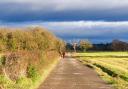
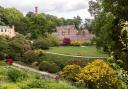
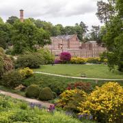
The TPT is not an uninterrupted route throughout its length but dodges about to avoid housing or industrial sites before plunging into woodland and parkland again before skirting motorway slip-roads and negotiating underpasses close to speeding traffic. These zones on the fringes of built-up areas have been called Edge lands, a good descriptive word for land that is not proper countryside. This is the territory traversed by the TPT.
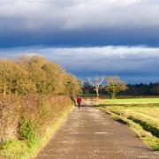
Our last ride was on the Middlewood Trail described in last month’s Cheshire Life, the track of an old railway that is mostly rural, a completely different experience to the TPT. We chose the section between Didsbury and Stretford to sample the trail, following the course of the River Mersey for most of the way, here tamed between embankments and not navigable.
The multi-use path has been provided but not surfaced so you have to ride for a lot of the time on compacted rubble squashed down with the heavy roller but not top dressed, the surface fine for those with the knobbly tyres of mountain bikes but a bit bumpy for road tyres. This does not always make for agreeable cycling and concentration is needed to avoid broken bricks and ruts. Other trail-users include a high proportion of dog-walkers, the surroundings ideal for letting the dog off the lead, creating conflict between animal and machine at times and you need to keep your wits about you.
1 We parked on the cinder car park at the end of Ford Lane beyond Didsbury Rugby Club where access can be gained to the river bank where the lime-green painted Simon’s Bridge crosses the river. Cross the bridge and take the path past Didsbury Golf Club to join the access lane to the club house, the river on your right. The lane passes under the M60 and we follow a quiet road lined with parked cars past St Wilfrid’s Church and then turn down right at the Crown Inn.
2 Descend to the river where a recreation area has been developed and given the name Northenden Riverside Park that longs to be like the seaside but isn’t. Turn onto the path beside the river and in a short distance we leave the park and cross a road at pedestrian lights. The other side there is a K Barrier designed to allow bikes and buggies through but not motorbikes and we enter woodland on a narrow path along the back of houses.
3 Cross a plank bridge over a sunken ditch, go through a wood and leave by another K Barrier to turn right on a quiet road to head under the motorway again. Cross a bridge over the river using the pavement beside a bus lane and once over it take a signpost on the right down to the river bank where we turn right on the riverside path.
Go under two bridges, the second brick-built with three arches, unusual among so many that are pre-cast concrete. The path we take now is unsurfaced but easy enough until another obstacle presents itself in the construction site for the building of a new line to Manchester Airport where metal barriers have been erected to funnel trail-users past the works. Completion is due in 2016.
4 Just beyond we come to a footbridge crossing the river and this is the access to Jackson’s Boat pub named after the ferryman who used to row people across the river here. You can also hire bikes here, an hour’s use of a mountain bike costing £6 for adults and £3 for children. They also have some unicycles for hire if you’re feeling acrobatic.
Those not visiting the pub don’t cross the footbridge but continue on the riverside path, the surface becoming rougher and less comfortable to ride. The scrub-land to the right is Chorlton Ees, once a sewage farm but now a nature reserve.
While researching this ride I was stopped by two elderly cyclists who asked if I had a pump. I obliged but the tyre would not take the air and I remarked that it appeared to be punctured.
‘It’s your pump,’ said the cyclist. ‘It’s knackered.’
He handed it back to me, shaking his head as if to say ‘what is wrong with people, lending out faulty pumps?’
5 On reaching Hawthorn Road we decided to turn back, the rain coming on. Plenty of people will continue as far as Stretford and indeed beyond but bear in mind this is a linear route and when you turn back you will have been half way. Retrace the journey, the ride back a little easier because it is more familiar.
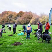
The TPT is a route that has the great advantage of being traffic-free for most of its length which makes it ideal for families with children. Cycling on public roads is becoming ever more hazardous and trying to marshal children in proximity to fast-moving traffic is problematic. Why not give the TPT a try? In spite of my reservations, it’s good fun and well worth the effort.
Compass points
Area of ride: Trans Pennine Trail between Didsbury and Stretford
Distance: 12 miles including return
Time to allow: 2½-3 hours
Map: OS Explorer 277 Manchester & Salford
Refreshments: Jackson’s Boat Pub
Useful web site: www.transpenninetrail.org.uk
The whole route is covered by three full-colour maps published by the Trans Pennine Trail Project.