Wells, water, plague and pilgrimage feature in Sally Mosley’s gentle hike around two of Derbyshire’s most historic villages
DESCRIPTION:
DISTANCE: 4 miles
PARKING: Hawkhill Road, Eyam S32 5QP (pay and display or free car park behind) Grid Ref: 216767
TERRAIN: Three gates. Five stiles. Roadway without pavement. Eroded holloway and woodland path with trip hazards. Fields with livestock grazing. Electric fencing.

REFRESHMENTS: Various tearooms in Eyam. Toll Bar Fish & Chip shop, Stoney Middleton
TOILETS: Hawkhill Road, Eyam
MAP O.S.: Explorer OL24 – White Peak
WALK HIGHLIGHT: The poignancy of Riley plague graves

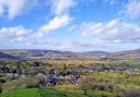
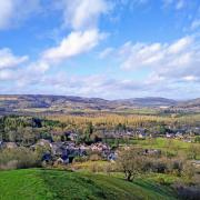
DESCRIPTION: Join visitors who travel from around the world and pay homage to the 17th century residents of Eyam whose courage is renowned. Although having different religious views, the names of Thomas Stanley and William Mompesson are eternally immortalised for uniting in their Christian beliefs and together encouraging the villagers to isolate themselves from the outside world during the catastrophic outbreak of bubonic plague in 1665/6. This walk is a wander along old paths and tracks between two picturesque Peak District villages with interesting histories and a staunch community spirit that continues in the present day.
1 As you exit the car park look across to Eyam Museum with its weathervane featuring a rat. Turn left down Hawkhill Road passing Hall Hill troughs, part of a series of troughs established in 1558 to provide water for domestic and agricultural use. They are said to be one of the first such water supplies in the country.

2 At the junction turn left along Church Street and walk past Eyam Hall, a Jacobean style manor house that is now leased by the National Trust, although still owned by the Wright family who lived here through nine generations until 2013. Built in 1676 it is reputedly haunted by the ghost of an old man seen sitting at a table in one of the top storey rooms.
3 Eyam Church is dedicated to St Lawrence. Within is the Revd Mompesson’s chair carved MOM 1664 EYUM. Somehow in the 19th century it found its way to a second-hand shop in Liverpool where it was discovered by a former rector who purchased the chair and presented it back to St Lawrence’s. The interesting wall paintings had been painted over and were only rediscovered in 1962. A ledger lists the dates and names of plague victims which by August 1666 had reached 78, almost a third of the village’s population.
A stone in the vestry reputedly records the death of Joseph Hunt and his wife Ann. He was Eyam’s rector and she was the daughter of a village publican. One day whilst under the influence of alcohol, the rector and Ann evidently took part in a mock wedding ceremony. However, the Bishop found out and insisted on their marrying for real and legally. This caused uproar and a breach of promise law suit as the rector was already engaged to a Derby woman. Some years passed in litigation which cost the rector his money and his friends and resulted in him taking permanent shelter in the vestry where he remained in sanctuary until his death in December 1709.
In the churchyard is one of the best preserved Saxon crosses in the country dating from around AD790. On the church wall is an interesting sun dial whilst nearby is the tomb of Katherine Mompesson, wife of the Revd William Mompesson.
Beyond the church is Eyam School where the entrance gates are decorated with the nursery rhyme ‘Ring-a-ring o’ roses, a pocket full of posies. A-tishoo! A-tishoo! We all fall down’ – thought by some to have originated in the village and based on aspects and symptoms of the plague.
4 Walk downhill to The Square and cross over to the phone box. Walk up The Lydgate which was one of the main routes into the village long ago. It would have been barred by a strong gate with ‘watch and ward’ kept every night in turn by householders who would question anyone wishing to enter. You will see the Lydgate plague graves on the right.
5 As Mill Lane bends around and descends to the left go straight ahead on a footpath leading to the boundary stone which separated the plague stricken Eyam from its non-infected neighbours at Stoney Middleton. The top was drilled with six holes where money left in vinegar (believed to kill infection) was exchanged for food and supplies. From this elevated spot there are lovely views over to the string of gritstone Edges that flank the eastern side of the River Derwent.
6 Follow the footpath as it descends steeply to Stoney Middleton. On reaching a road turn right and walk down to the junction at Cliff Bottom where there is an information board for the Stoney Middleton Heritage Trail. Down to your right is the busy A623 which was a former turnpike road established in 1743. Notice the hexagonal toll cottage where a fee would have been paid long ago to use the road. Now your money can purchase award-winning fish and chips here.
7 Continue on the back street passing a weathered green door on the right which leads into an old mill building. This is the entrance to William Lennon & Co, the last heavy duty boot manufacturers in the country. They make Rufflander leather safety boots and shoes, Farmer’s and Tug-of-War boots, and their unique Arturo cycle shoes.
8 Turn left at the little crossroads and walk around The Nook to Stoney Middleton’s unusual church. The original house of worship here was built by Joan Eyre of Padley in thanksgiving for the safe return from Agincourt of her husband Robert. However, when the nave was destroyed by fire in 1757 it was rebuilt in an octagonal form with an inward-facing arrangement of pews.
Follow the road around, passing quaint cottages, and continue to the old ‘Roman Baths’. For centuries the spring here was thought to have healing qualities resulting in the construction of a bath house with separate pools for men and women to bathe in the water which emerges from underground at a constant temperature of 63° Fahrenheit. In 1734 Dr Short’s Treatise on Mineral Waters claimed that the water could be ‘drunk more freely and safely than at Buxton, as it is cooler.’
9 Turn left up Jacob’s Ladder with the cemetery on your right and walk up this old track which is now badly eroded, creating lots of trip hazards. In spring you can find celandines and bluebells here but in summer look for foxgloves or campion and drink in the scent of wild honeysuckle.
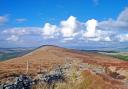
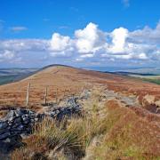
10 Arriving at the closed road from Grindleford to Eyam, cross diagonally left and head up the footpath opposite. At a gate before entering woodland, look behind to admire the distant views. To the east there are high escarpments topped by dark and forbidding moors. See if you can spot the turreted tower of White Edge Lodge which featured as Moor House in the 2011 film adaptation of Jane Eyre. To the south you might make out a white plume of spray from the Emperor Fountain at Chatsworth, while to your right lies Coombs Dale which appears like a deep cleft in the limestone hills beneath a windbreak strip of trees exposed to the elements on the high skyline.
11 Enter woodland through banks of gorse and head up to a junction. Bear left and continue as the path becomes a narrow lane where in a field on the right is a walled enclosure containing the Riley plague graves. Here Elizabeth Hancock buried her husband and six children during eight days in August 1666.
12 Continue along the lane to arrive back in Eyam, heading down The Causeway to The Square. Retrace your steps along Church Street to return to the car park. If possible end your walk with a visit to the excellent small Museum (open Tuesday to Sunday until 30th October 2016).