Nestling at the head of the Amber Valley, the widespread parish of Ashover covers a rolling landscape criss-crossed with old tracks, paths and bridleways. Sally Mosley takes us on a route through countryside that is a paradise for walkers and also packed with interest for local historians
Details
DISTANCE 4.5 miles
PARKING Free car park at Ashover Parish Hall, Milken Lane, Ashover S45 0BA (SK351632)
TERRAIN There are six stiles, three gates and several sets of steps as well as a steep incline to The Fabric. Some paths have uneven terrain and are prone to mud. You will pass a flooded quarry, please observe warning notices and keep to the path. There are sections of road walking without pavements.

REFRESHMENTS Various pubs and a tearoom in Ashover; The Nettle & Miners Arms, Milltown
TOILETS Public toilets at Moor Road, Ashover
MAP OS Explorer 269
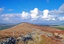
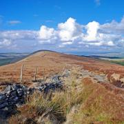
WALK HIGHLIGHT An incredible view when you reach the top step approaching Ashover Rock.

Description
This walk begins with a gentle hike up to The Fabric, an elevated ridge of gritstone – be sure to bring your binoculars to make out the distant Crooked Spire, Bolsover Castle and Hardwick Hall! Following quiet lanes, this walk then drops down to amble with the River Amber, passing the ruins of Eastwood Hall, as you head to the remains of Gregory Mine, reputedly one of the most profitable in the Peaks. The return to Ashover is along a series of wonderful old miners paths.
Route
1. From the car park turn left, and then follow a footpath on the right just before the Black Swan Inn across a field to a lovely walled path leading to Farhill. On reaching a lane turn left to walk past Eastwood Cottage and then continue uphill on a footpath and series of steps to Ashover Rock and trig point at an area known as The Fabric. The name is said to come from stone quarried here, some used in the construction of Ashover Church. Land left in trust for church purposes was often called fabric land because it provided material or revenue ‘ad fabricam reparandam’.
2. Weather permitting the views from this ridge are breathtaking. With the circular pointer map to assist, you should be able to make out extremely distant landmarks. Follow a short path to the rear of Ashover Rock which drops down through heather and bilberry to Alton Lane. Turn right and follow the road to Littlemoor, keeping well under the side as there are no pavements.
3. On reaching Littlemoor, turn right to walk past the phone box and Primitive Methodist Chapel and then turn right up Eastwood Lane, a narrow road which winds down to pass the long derelict Eastwood Hall. These ivy clad ruins are all that remain of an Elizabethan manor house destroyed in 1646 by a party of Parliamentarian soldiers as described in the following: ‘The Roundheads they came down upon Eastwood Old Hall, They tried it with mattock and tried it with ball, They tore up the leadwork and splintered the wood, But firmly as ever the battlements stood; But a barrel of powder at last did the thing, And then they sang psalms for the fall of the King.’
4. Follow Eastwood Lane down to the junction. Turn left for a short distance and walk to a stile then follow a path beside a high wall which leads to Fallgate. You will pass a deep flooded quarry which is extremely dangerous. Do not cross over the fencing and take heed of warning signs.
5. Turn left when the footpath emerges at a road and walk to a junction. At this point you may wish to take a short detour up the road to visit The Nettle Inn which is said to be named after a racing greyhound. Alternatively turn right and follow the sign for Milltown. Walk past a selection of lovely stone houses and cottages and keep under the side as there is no pavement. Just before a detached stone barn in the field to your left cross over the river on your right and follow a riverside path downstream to emerge at the side of the Miners Arms.
6. Turn sharp right in front of the pub and head up a single track lane between high hedgerows packed with holly, hawthorn and honeysuckle.
7. Bear right at a junction when you see the sign for a no through road. The lane heads uphill and around a bend before leading towards woodland beneath Cocking Tor. Walk past the notice advising that this is a Private Road with Access Only and continue past the drive leading to The Beeches and then straight ahead past a house on a path leading steeply up to spoil heaps where a chimney marks the site of the former Gregory Mine.
8. Try to avoid walking into any dips and hollows. Head towards the top right corner of these old workings and you will see a solid wooden barrier to restrict access to walkers and pedal cyclists only. Follow this fabulous old miners’ path through woodland to the rear of Overton Cottages. Notice in parts the old stone flags worn away by time and the passage of countless work boots. A bizarre Ashover story tells of Dorothy Mately, a local woman, who died in 1660. She was employed as an ore washer in one of the mines hereabouts but had a reputation for being an unscrupulous liar. Her favourite saying was ‘I would that I might sink into the earth if it be not so.’ This proved to be her downfall on 23rd March 1660 when accused of stealing 2d. She strongly denied it but was seen to sink deep into the ground together with her wash tub. When her body was recovered, the missing 2d was found in her pocket!
9. Arriving at the drive to Overton Hall, head across to walk up a tree-lined avenue which is the old carriage route to the house. Overton Hall was inherited in 1792 by Sir Joseph Banks who went around the world with Captain Cook and persuaded Australia to become a nation.
10. At a junction of paths close to a set of old gate posts you can either follow a diagonal footpath across the field or turn left along Salter Lane, also known as the Coffin Road and walk past the ‘tombstone’ wall to access a bridlepath down a deep holloway edged with spring flowers. Both descend to cross the infant River Amber before a lovely walled path leads you back into the village, emerging at the side of The Poets Corner, voted pub of the year in 2013 by Chesterfield & District CAMRA.
11. Walk up to All Saints’ Church with its delicate spire topped with a replacement golden cockerel weathervane. The original, some 250 years old, was dislodged in an earthquake in February 2008. The church contains a lead font dating from 1130, one of only a handful in the country, and the tomb of Thomas Babington of Dethick who in 1416 returned victorious with his men of ‘Asher’ from the Battle of Agincourt.
12. The Crispin Inn next door has an interesting plaque on its front wall giving details of the uprising of 1646 during the Civil War when soldiers to the King turned the landlord out and drank the inn dry, forgetting both King and Cromwell! Across the road are the ornate looking Bassett Rooms, renamed in February 2002 to mark the centenary year of local lady Elisabeth (Betty) Bassett whose family confectionery firm created the famous Liquorice Allsort. It is now just a short walk up the road to return to the car park.