Sally Mosley takes us on a walk that includes the picturesque side-by-side villages of Hopton and Carsington. Set in a landscape heavily influenced for centuries by man’s intervention, they abound with curiosities and relics from the past while nestling beneath limestone slopes now topped with futuristic features
Distance: 4.75 miles
Parking: Pay and display car park at Middleton Top DE4 4LS (SK275552). Approached off the B5035 Middleton-by-Wirksworth to Ashbourne road
Terrain: Uneven terrain on well-defined paths, tracks and quiet roads. There are eight stiles, seven footpath gates, numerous steps and a very steep grassy bank leading up to Carsington Pasture.
Refreshments: Miners Arms, Carsington www.minersarmscarsington.co.uk 01629 540207

Toilets: Public toilets at Middleton Top car park
Map: OS Explorer OL24
Walk Highlight: Far-reaching views over Carsington Water

Description
This route begins and ends with a stretch of easy walking along the elevated High Peak Trail, originally constructed as one of the world’s earliest and toughest railway lines where steam trains had to manoeuvre seriously steep inclines. The middle section of walk crosses fields and stiles dotted with dips and hollows of old lead mine workings taking you to the quiet road through historic Hopton and charismatic Carsington. Hopton Hall is famed for its snowdrop display and summer gardens which are open on occasion to the public. To see the snowdrops this year, they will be open every day from Saturday 1st February to Sunday 2nd March, see www.hoptonhall.co.uk for details.
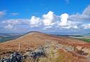
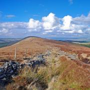
After a steep climb up a grassy bank to Carsington Pasture, see if you can find a limestone boulder known as the King’s Chair, an isolated and exposed regal throne with majestic views.
Route
1 Spare a few minutes to look around the Middleton Top complex with landmark engine house built in 1829 by the Butterley Company. Notice near the door of the gift shop some sections of early fishbelly cast-iron rail. From the Visitor Centre set off along the level trail, guided by a fingerpost indicating the direction of Parsley Hay where the High Peak Trail meets the Tissington Trail.
2 After approximately 750 yards pass through a gate and turn sharp left to a public footpath sign beside some large rocks. Proceed down a flight of shallow steps to a footpath gate and immediately turn right to head down the wall side and then uphill to cross a tall ladder stile. Walk diagonally across the next field to emerge onto a road.
3 Cross the road and return to the footpath over fields and stiles where there are numerous dips and hollows, scars from lead mining which was extensively worked in this area until the end of the 19th century, the profits paying for most of early Wirksworth to be constructed. DO NOT walk into any of the hollows! As well as shafts descending deep into the Derbyshire hills, you will observe long stretches of abandoned workings known as rakes where the lead was extracted from close to the surface. Also from this high vantage point and on a clear day you should be able to make out Crich Stand, a cliff-top war memorial tower of the Sherwood Foresters Regiment (now 2nd Battalion Mercian Regiment). To the right of this is Alport Heights which looks like a pin cushion with its seven masts. After passing through a gated gap in a blackthorn hedge you should get your first view of Carsington Water.
4 Continue to follow the footpath as it descends beside a rugged outcrop of rocks before passing through more former mine workings with a post to guide you. Cross a narrow walled track which long ago was part of the King’s Highway leading north from Derby, this section was known as Tiremare Lane. After a small wood on your left head diagonally right down a large field to emerge by a junction on the B5035.
5 Turn right and walk into Hopton, passing character cottages and a row of almshouses founded in 1719 by Sir Philip Gell. The badly eroded plaque states that the dwellings were a ‘hospital’ for ‘two poor men and two poor women of Hopton and Carson’. A little further on is a house with a most unusual stone carving on its roadside wall which is thought to depict George and the Dragon. See also the white painted milestone from when this stretch of road formed part of the ‘Alfreton’ to ‘Ashbourn’ turnpike road. Keep well into the side as there are no pavements.
6 Around the corner notice a former toll cottage on the right and redundant ice house in the private field beside it. The most interesting feature however is the crinkle crankle brick wall with tall summerhouse folly encompassing the gardens of Hopton Hall. The summer gardens abound with a riot of colour, but in February Hopton opens its woodland gardens to the public to enjoy a dazzling display of snowdrops and aconites. The Gell family held estates at Hopton from 1327 until 1989, their wealth profiting greatly by lead mining. The part Elizabethan house was much altered in the 18th century with several later extensions and additions. Around 1800 Philip Gell was responsible for laying the Via Gellia road to link his mines with the newly constructed Cromford Canal. A mill in the valley produced a woollen fabric called Viyella, an adaptation of the road name.
7 Notice the boundary stone as you walk between the back-to-back ‘townships’ into Carsington which has a recently improved village green and play area. The main street is relatively quiet thanks to the by-pass road being laid following the construction of nearby Carsington Water.
8 After St Margaret’s Church, turn right at the bend to head up Mining Lane. Walk past a quaint cottage with trough built into its front wall, and continue straight up the path and steps beneath an arch of foliage to a small gate at the top giving access onto the path heading steeply up to Carsington Pasture. Make your way carefully up the steep incline with footprints to guide you, eventually arriving at a stile.
9 Do not go through but turn away from the wood and walk with the wall to your right, heading towards a daisy chain of majestic wind turbines which were erected at the end of 2013.
10 See the King’s Chair just over the wall, being a rugged boulder of limestone, shaped like a throne, with wondrous views over Carsington Water and the rolling hills of South Derbyshire. Be guided by construction signs and follow the footpath around the corner, eventually emerging onto a road.
11 Notice in the field to your right the derelict remains of a windmill, confirming that Carsington Pasture has long since been utilised to harness natural wind power. Although there is much evidence of quarrying, mining and mineral processing in the area, this is still a place of beauty, and a valuable habitat for birds, whilst in spring many of the spoil heaps and meadows display a carpet of wild flowers. The high rocky crags over to your left are Harboro Rocks, said to contain a cave or rock shelter dating back to prehistoric times. In the 1720s Daniel Defoe passed here on his ‘Tour through Britain’ and came across a poor lead miner emerging from a shaft. He described him as ‘a subterranean creature, lean as a skeleton and pale as a dead corpse, his flesh lank, something of the colour of lead itself’!
12 Cross the road to rejoin the High Peak Trail at Viaton Crossing and follow the fingerpost for Middleton Top. Shortly after this you will come to the cottage at Hopton Top with Hopton Incline beyond. With a gradient of 1 in 14, this was the steepest hill to be worked regularly and unaided by conventional steam locos on British railways, some taking several attempts to reach the top! The route back is easy as you walk through a cutting and tunnel, following in the tracks of the last train which ran in 1967.