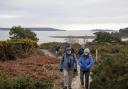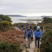

Edward Griffiths discovers a town tucked away in the heavenly hills of West Dorset with a river running through it and glorious views
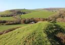
In his 1965 book Portrait of Dorset, Beaminster resident, radio broadcaster and writer Ralph Wightman, says: ‘Beaminster is entirely surrounded by hills, like a basin, except for a narrow winding river valley towards Netherbury’. In The King’s England of 1939, Arthur Mee is more poetic, saying: ‘Beaminster lies among the heavenly hills of West Dorset, a charming little place in a rich valley, with a rampart sheltering its farmers and their kine.’ On this fine walk, we cross the young Netherbury-bound River Brit before climbing two of Beaminster’s hills to enjoy the glorious views over the delightful ‘basin’.
Information
• Distance: 5 miles (8 km)
• Time: 4 hours
• Exertion: Fairly strenuous with a few ascents. Some mud after rain.
• Start: The Julia Memorial, Beaminster Square (Reference SY480013)
• Map: OS Landranger Sheet 193
• Public Transport: First 53 from Bridport, Damory 40 Bridport to Yeovil
• Dogs: On leads in fields with livestock and on roads
• Refreshments: The Greyhound Inn, The Red Lion and several Beaminster restaurants
The walk
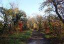
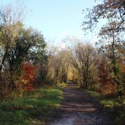
1. The covered market cross known as the Julia Memorial was built in 1906 by Vincent Robinson of Parnham in memory of his sister Elizabeth Julia Robinson. Turn down Church Street and turn right to pass St Mary’s church with its magnificent tower. Continue into Shorts Lane and, in 200 yards, the bridleway-track, meeting a tributary of the infant River Brit. Cross a driveway to 1½ footpath-gates and walk through the long field to the bridleway half-gate onto a lane. Turn left. Past left Culverhayes, continue up the banked lane. On the top, take the left bridleway-track, rising between banks before expansive views to Gerrards Hill right.
2. Over the footpath-stile/gate, with a remnant of a massive stone Parnham House gatepost, veer very slightly left to the bridleway-gate, then follow the track descending around the left ‘arena’ field to a bridleway-gateway. Through, follow the right hedge down to another facing gate. Through, follow the left hedge to another bridleway-gate. Through, follow the right fence to the bridleway-gated bridge to Parnham’s Deer Park gate. Cross the park, following the white-topped bridleway-posts, to the exit gate under trees. Follow the enclosed path to the A3066. Carefully, cross into the bridleway-path opposite, turning right along the orchard’s edge. At the bridleway corner-post, turn left uphill. Passing above the right farmyard, continue up the bridleway-arrowed, fenced path before dropping down into the sandstone ‘gorge’. Keep climbing this ancient hollow-way.
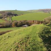
3. Later, there is a superb viewpoint over Beaminster to the surrounding rim of hills. Nearing the top, emerge into trees alongside a fenced track. At the multi-arrow post, turn right alongside the right fenced track, with fabulous views to Langdon Hill and Lyme Regis. Soon, joining the track itself, continue uphill with pine clumps all around. Through the facing gate, keep straight on along the right fence on the top of Coombe Down Hill, then follow the fenced and hedged bridleway-track. Through the facing bridleway-gate by left barns, follow the fence across the field to the corner bridleway-gate. Through, follow the track down with views across the left valley to Storridge Hill in the middle distance. Reaching a lane T-junction, go left. Pass a left gated farm-drive. In 100 yards, at a bridleway-signed crossing, turn left down the stony bridleway-track with a left field and right hedge.
4. Continue down into the valley. Through two facing bridleway-gates, keep to the track, undulating under trees into a valley field. Now follow the right edge down, above the right wood. Bending right, follow the path through the half-gate into the wood, and continue to a bridleway-bridge over another tributary of the River Brit. Over, go through the gate out of the wood into the valley. Turn right up the steep field to the footpath-gate in the right fence. Through, walk straight across the long sloping field to the right wood’s fence corner. When a facing gate appears ahead, look out for a two-way footpath arrow post in the wood’s fence. Here, turn left and walk up the steep field. Pass the right fence’s footpath arrow-post on the way up Storridge Hill. Through the left of two gates on the top, cross to the roadside footpath-gate and cross the road into Storridge Farm’s concrete drive which is a Permissive Path.
5. With fine views, descend the farm track, keeping farm cottages and barns to your left. Bend left/right around the last buildings to continue down the hedged and fenced farm track. Up to a three-way footpath arrow-post, keep straight on. Through a facing gate, continue down the hedged track to a lane‘s bend. Keep straight down, leaving fields behind and entering Beaminster. Through Hollymoor Road estate, pass right Woodswater Lane and continue into East Street, with lots of old stone cottages. In 300 yards, at the T-junction, turn right for ‘Mosterton’ and pass Beaminster Museum. At the A3066 T-junction, turn right up the hill, passing the Red Lion. Return to the Julia Memorial where you started.
More…
• Dorset walk around Broadstone & Canford Heath - Edward Griffiths explores a wild heath landscape near Poole which is home to some very rare residents