Edward Griffiths enjoys a waterside ramble with seaside vistas, a nature reserve and a visit to an elegant cliff top castle
The River Mude rises in Hinton Admiral in Hampshire and meanders slowly to Christchurch Harbour. The rivers Stour and Avon flowed into the harbour much higher up but, all together, their combined waters race out of the harbour entrance, known as ‘The Run’, as each tide ebbs.
This walk meets the River Mude and follows the Mude Valley Greenway back to the harbour, but not before enjoying a seaside stroll, an exploration of a Nature Reserve with mirror-flat ponds, and a visit to an elegant cliff top castle.
Information
• Distance: 4½miles (7.25 km)
• Time: 3 hours
• Exertion: Easy level walking. Some mud in woods.
• Start: Mudeford Quay (Grid Ref: SZ185918)
• Map: OS Landranger Sheet 195
• Public Transport: Wilts and Dorset X1, X2 and Yellow Buses 111
• Dogs: On leads on roads
• Refreshments: The Noisy Lobster at Avon Beach, Beach Hut Café at Friar’s Cliff
The walk
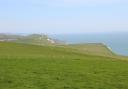
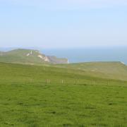
1 From the car park, follow the guard railed harbour wall alongside ‘The Run’. Then follow the beach path along the concrete wall with caravans and pines behind. Past Avon Beach car park and The Noisy Lobster Café, join the Tarmac promenade past the shop and beach huts. Reaching Friar’s Cliff, there are benches at the top with fine views to the Isle of Wight. Continue past all of the beach huts, on the promenade now. After the Beach Hut Café, walk along the sea wall with scrub-covered sandy cliffs. When the sea wall ends at higher cliffs with Holm oaks, continue for 50 yards. Then climb the 76 ‘Highcliffe Castle’ to ‘Steamer Point Nature Reserve’. Turn left onto the path into trees above the cliffs.
2 Meander through to the Tarmac path and turn left again. Pass right ponds. When they end, take the right path, before the fenced path. Over the ponds’ outlet trickle, go left at the next T-junction and bend round right along the low laid branch fence. Meander along this path, passing two left turns and a right, now with the Golf Course’s fence left and heading east. Past another right turn, keep following the path nearest the fence. Eventually, turn right along the fence towards the cliff-top. Go through the high ‘Steamer Point Nature Reserve’ gates. Follow the wide path past ‘Highcliffe Castle and Grounds’ information boards and through wooden gates. Keep straight on, near the cliff top fence to a lawn with Highcliffe Castle left. Cross left to three iron benches. Double back left onto the ‘Highcliffe Castle and Tea Rooms’ path.
3 Highcliffe Castle was built by Lord Stuart de Rothesay in the early 1830s. During construction, an old steamer was wedged into the cliffs and used as a site hut. Later it was used as a summer house; hence the name. Two fires made the building derelict in the 1960s but it was restored by Christchurch Council and re-opened in 1995. Pass through the formal gardens to the Car Park drive and turn right. Through the gates, cross into Rothesay Drive and continue to Lymington Road. Turn left. In 250 yards, cross over into Nea Road, becoming Copse Way then Smugglers Way South. Passing right Nea Meadows Local Nature Reserve, cross the Bure River bridge and walk up to Smugglers Lane North T-junction. Turn left. Follow this pleasant road, passing several left and right turnings. Descending past left woodland and farm buildings, the road becomes Hoburne Lane. Pass Hoburne Park behind the left hedge.
4 Reaching Highcliffe Road roundabout, go left to the pedestrian crossing and cross onto the ‘Mudeford’ path over the wide verge and along ‘The Runway’, with World War II airfield buildings right. Past right Prior Industrial Park, cross into right Brabazon Way. Take the immediate fork onto the Tarmac ‘Mudeford Wood Community Centre’ footpath/cycleway and urban wildlife corridor. In ¼ mile, arriving at the Community Centre, pass in front and take the left ‘Mudeford 1¼ Cycleway 2’ path. Follow the right hedge through the recreation ground. This is part of the Mude Valley Greenway. Passing into scrub and gorse, meander for 100 yards. Take the left ‘Mudeford Quay’ path. Out into a cul-de-sac, continue past garages and round a right bend. Pass left Grebe Close and bend left.
5 Leave Curlew Close, for such it has been, at a T-junction. Turn right and cross over De Haviland Road. Cross Peregrine Road and take the instant left path into Peregrine Wood, again Mude Valley Greenway, with its many alders. Meander along right River Mude, past a footbridge and along the riverside path into Raven Way. Turn right. Over the River Mude bridge into ‘Saxons Landing’, turn left into Osprey Close. At the end, continue along the block-paved path to the wooden gate into Mudeford Lane. Turn left. At the T-junction with All Saints’ Church left, go left into ‘Mudeford’. Cross left Mude Gardens, cross the River Mude and Farm Lane. Past left shops, take right Chichester Way back into Mudeford Quay car park, walking along the edge of Christchurch Harbour on the way.