Helen Moat takes a lovely walk from Eyam to the trig point at the highest point on Sir William Hill, with 360° views across the Peak District.
Sir William Hill – is located on Eyam Moor, although no one knows for sure who ‘Sir William’ was.
It could be one of four Chatsworth dukes named William Cavendish or Lord of the Manor at Eyam, Sir William Saville.
Then again, it could be Sir William Bagshaw, who was High Sheriff of Derbyshire at the beginning of the 19th century.
Whoever the mysterious Sir William is, this is a lovely walk from Eyam to the trig point at the highest point on Sir William Hill, with 360° views across the Peak District.
The outlook takes in many of the other Ethels in the area, including Higger Tor, Kinder Scout, Win Hill and Mam Tor.
So why not lace up your boots this February and climb to the roof of Eyam Moor.

1. From Eyam Parish Church, follow the signed public footpath along the boundary of the graveyard.
If you haven’t visited St Lawrence’s Church before, drop inside to see the stained-glass windows depicting the story of the 1665-66 Plague; a moving and tragic story.
Outside, you’ll find the grave of Catherine Mompesson, whose husband ordered Eyam’s lockdown in order to protect the outside world – ultimately sacrificing his wife.
Continue up the well-defined path beyond the churchyard until you meet Edge Road. Cross over and follow the wooden fingerpost up steep steps through woodland, emerging onto open land at the top of the escarpment.
The path runs left along the edge with fine views of Eyam below before cutting up to a second (unnamed) road.
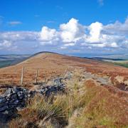
2. Turn left, and almost immediately you’ll see a fingerpost on the right. Climb over the steps in the wall and continue along the boundary of the field, keeping the drystone wall on your right until you hit Sir William Hill Road.
This is a grand name for the unmade track, an old packhorse route that was part of the Sheffield to Buxton Turnpike.
Cross the road, climbing over the steps inserted into the drystone walls adjacent and turn immediately left to follow the path over the moorland (keeping the wall on your left) to the trig point ahead of you.
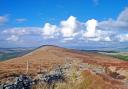
This is a great point to have a picnic, taking in many of the Peak District’s much-loved landmarks: the Kinder Massif, The Great Ridge, the popular edges that run along the Eastern Moors with a glimpse of Ladybower peeping out of the Dark Peak.
3. Continue along the ridge spread out below the trig point and enjoy the magnificent views over to Hathersage.
The ridge path soon meets another footpath. Backtrack to Sir William Hill Road again by turning right here.
4. Cross over the track to retrace your outbound route through the field, the drystone wall now on your left.
Look out for the chimney stack of Ladywash, mined for fluorspar up until 1979. On cold winter days, the warm air of the mineshaft bellows out steam as it hits the chilled air on the surface; a strange phenomenon.
Hitting the unnamed country lane again, turn left to drop down to Edge Road.

5. Turn left again to detour to Mompesson’s Well. Eyam residents were not permitted to stray beyond the boundary here. Instead, they left money disinfected with vinegar in exchange for medicines and food from surrounding settlements.
Retrace your steps to the junction, continuing downhill along Edge Road for a short distance. Follow the wooden fingerpost on the lefthand side of the road through the steep-sided gorge of Hollow Brook to Town End on the edge of Eyam.
6. Continue along Riley Back Lane and turn right into New Road and The Causeway, then along Church Street back to your starting point.
AT A GLANCE
Distance: 3.3 miles
Map: OS Outdoor Leisure 24: The Peak District, White Peak Area
Grid Reference: SK 2179 7636
Difficulty: There’s a short sharp rise out of Eyam up the escarpment. Once on top it’s an easy tramp.
Parking: There is some parking on Church Street (please park considerably with residents in mind). Otherwise, there’s a car park opposite Eyam Museum (worth visiting to find out more about the Plague) on Hawkhill Road.
Refreshments: The Miners Arms on Water Lane is a great spot for pub grub. There are two great cafes in the centre of the village: Village Green Café and Eyam Tea Rooms.
Easy Alternative: Park at the junction of Edge Road and Sir William Hill Road for a short and more level walk up to the trig point.
The photos in this article were uploaded to our Derbyshire and Peak District Facebook group, join the community to find inspiration for your next walk.