Shake up your exercise break with a walk along the Alre Valley and over the Downs.
New Alresford, commonly referred to as just Alresford (pronounced Allsford), is a fine Georgian town situated on the south side of the River Alre. The original settlement, the quiet village of Old Alresford, lies to the north.
Despite its name, the former dates to the 12th century when the Bishop of Winchester built a causeway (the Great Weir) over the river creating Old Alresford Pond. This was to link Old Alresford with a new town, Novum Forum, which became New Alresford and thrived as a prosperous wool town, a market being held in Broad Street, as it still is today. Fires in the 17th century destroyed the original timber-framed houses, so much of the architecture seen today is Georgian.

Alresford is known as the UK’s capital of watercress farming, the springs of clear, pure water providing ideal growing conditions, their constant temperature allowing year-round cultivation. Although watercress had always grown wild in the chalk streams around the town, it was the coming of the railway in the 1860s that turned it into a commercial industry, enabling quantities of locally grown watercress to be transported to London’s Covent Garden market. The line was closed in 1973 but re-opened as a heritage railway a few years later, initially from Alresford to Ropley, thereafter extended to Alton, a distance of ten miles in total. Nicknamed the Watercress Line, today it is one of the most successful heritage railways in the country.
Alresford’s annual Watercress Festival usually takes place on the third Sunday of May each year, the town becoming the site of a huge street festival. This year, because of coronavirus, the Arlesford Watercress Festival has gone virtual with plenty of online events to explore from Monday 17th May to Sunday 23rd of May. There will Q&A's, history talks and plenty of tasty recipes (use #cookingwithwatercress to share your creations online).
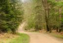
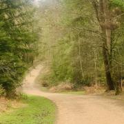
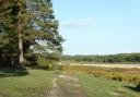
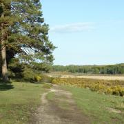
Alresford is surrounded by some lovely countryside, with a good network of footpaths and bridleways providing scope for various walks of different lengths. Around the town itself, there is a short circuit called the Millennium Trail with display boards about the local history along the way, and a longer version, with an additional loop, called the Alre Valley Trail. This walk follows the initial stretch along the picturesque riverside, thereafter heading northwards to Abbotstone, passing the site of the medieval village. The return leg over rolling downland leads to Old Alresford (an alternative starting point if preferred), from where it’s an easy walk back to town.

Compass points
Start/finish: Station car park (pay & display), New Alresford (SU588324) or Christy village hall car park (free) and nearby roadside, Old Alresford (SU587340)
Map: OS Explorer OL32
Distance: 6 miles (9.8km)
Terrain: Town roads, riverside path, downland tracks, country lanes
Time: Three hours
Refreshments: Plenty of choice in New Alresford
Government advice: Keep 2m from others. Stay local to avoid unnecessary travel.
The walk
1) (SU588324) From the car park, walk down Station Road a short distance and, opposite the toilets on the left, take the diagonal path on the right leading into the churchyard, bearing left to the church. Continue along the path to the junction of East, West and Broad Streets. Carry on ahead down handsome Broad Street (a market is held here each Thursday).
At the bottom, where the road bears right, the walk keeps ahead down Mill Hill to the left. Continuing down the road (B3046) just a little further (no pavement initially, so take care) leads to the Globe pub and a path on the right leading to Old Alresford Pond. Retrace steps and carry on down Mill Hill, then turn left into Ladywell Lane, which leads to the riverside walk. It is also part of the route of the Wayfarer’s Walk, a waymarked long-distance path.

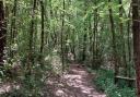
2) (SU587329) Walk down Ladywell Lane to Arle House at the end, continuing along the footpath which leads past the Memorial Garden on the left. The path carries on beside the River Alre on the right to the picturesque thatched timber framed Fulling Mill, which spans the river. Dating from the 13th century, water-driven hammers were used to work raw cloth into usable material. Carry on alongside the river to reach the end of The Dean (road).
Turn right, continuing along the footpath, soon passing a kissing gate on the left, Arlebury Park recreation ground beyond. A further stretch of riverside walking leads to the Eel House, a small brick building astride the river, built in the 1820s and recently restored. In the past, eels were trapped here on moonless autumn nights when they undertook their once-in-a-lifetime journey to breed. The path continues on the other side of the river, gently rising. Bear left, cross a drive and keep ahead, ignoring a right turn. On reaching the road, bear left.
3) (SU573327) Very soon, where the road curves left, turn right up the restricted byway, still following the Wayfarer’s Walk (also waymarked as the Watercress Way, a recently created route). Continue to a junction of tracks and bear right uphill to a lane.
4) (SU572335) Turn left along this quiet lane, passing the turning to Fobdown Farm. In the fields, either side of the road near where a track joins from the right and before the lane descends to the valley, the earthworks of the deserted medieval village of Abbotstone can be seen. Carry on down to the road junction.
5) (SU564345) Turn right, signed for Abbotstone Farm House, which is part of the Grange estate. Grange Park, where opera is staged, lies to the north. Still following the Wayfarer’s Walk, keep ahead at the first intersection, but turn right at the next junction. Follow the track northeast to reach a path intersection just after a ruined building.
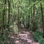
6) (SU575352) Leaving the Wayfarer’s Walk, turn right along the grassy field-edge footpath gently ascending and then descending as the path becomes a farm track. Watch for a waymark post on the right (at SU585345) and turn right along the footpath beside the hedge on the left, soon going through a gap in the hedge and continuing down through the middle of the field towards Old Alresford. Keep ahead at the bottom, keeping straight on down to a road. Turn left to the village hall car park (on the left) – an alternative starting point.
7) (SU587340) Cross the green on your right and the road (B3046) and turn right along a path parallel to the road, but screened from it. At the road junction cross to the church opposite to look round it. Then cross the B3046 and continue along the path beside it to a fork in the road. Bear right and continue along the footpath ahead over a stream that leads back to point 2. From there, retrace steps to the start.