Head to the north-west corner of Hampshire for some fresh air and great views on the downs says Steve Davison
The North Hampshire Downs, to the west of Basingstoke, forms the southern edge of the North Wessex Downs area of outstanding natural beauty which encompasses a large tract of unspoilt rolling chalk downland, an open landscape that offers some great walks as you’ll discover this month.
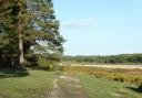
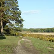
After setting out, the first part of the route heads down a peaceful wooded track with lovely views to the right towards Watership Down - anyone who has read Richard Adam’s book about a group of rabbits will recognise some of the place names around here. Soon the way levels out and we arrive at Sydmonton before heading north again…on the way take a look to the right to catch sight of Sydmonton Court.
The Sydmonton Court estate, named after Sydeman who was mentioned in 931 and ‘tun’ meaning ‘farm’, was owned by Romsey Abbey until the Dissolution of the Monasteries in the 16th century. The estate was then granted to William Kingsmill, and stayed in the family line for many generations. Sydmonton Court is now the country home of Lord Lloyd Webber of Sydmonton (aka Andrew Lloyd Webber) - please note that the church is private.
Soon we pass Wergs Manor and farm before following a bridleway uphill, gently at first, but getting much steeper before we join the Wayfarer’s Walk. For anyone wanting a more challenging walk, the 70-mile long Wayfarer’s Walk meanders southwards through Hampshire from Inkpen Beacon to the coast near Portsmouth.
Here we head northwards to reach the top of Ladle Hill (open access land), which is crowned by the remains of an unfinished Iron Age hill fort, while just to the north of the hill fort is a well-preserved disc barrow (burial mound). Take time to admire the views from this great vantage point. To the west and nearby is Beacon Hill crowned by the remains of another Iron Age hill fort - the hill is also the final resting place of George Edward Stanhope Molyneux Herbert – 5th Earl of Carnarvon – who helped in the discovery of the tomb of Tutankhamen in the Valley of the Kings, Egypt, in 1922. To the west-north-west you might catch sight of Highclere Castle, home to the Earls of Carnarvon. Views to the north extend across the Kennet Valley with the Berkshire Downs in the distance and finally, 25 miles to the north-east, are the Chiltern Hills.
After soaking up the views, the walk continues eastwards along the Wayfarer’s Walk back to the start. Although there is no pub on the walk, The Royal Oak at Ecchinswell is just a short drive away.
Information
• Distance: 4.75 miles (7.7km)
• Time: 2½ hours without stops
• Terrain: Steep up and down, tracks and paths which can be muddy, some stiles and gates, short sections of country road
• Start/Finish: Roadside parking on minor road near Nuthanger Down (SU491566) - from A34 head east past Sydmonton to a cross-roads and turn right for 0.75 miles to roadside parking on the right, at the top of the hill
• Map: OS Explorer 144
• Refreshment: None on walk; The Royal Oak (01635 297355) at Ecchinswell
The walk
1 (SU491566) - From the layby, follow the Wayfarer’s Walk westwards along the track for 200m, with large beech trees on the right. Turn right through a gate, pass an electricity pylon and follow the track steeply downhill (views to the right) and then continue between hedges towards Sydmonton. Cross a stile and turn left along the minor road for 175m. Turn right at the farm entrance and fork right through a gate, keeping to the right of the barn. Continue straight on (north) for slightly under half a mile – shortly after passing the buildings on the left look right to catch sight of Sydmonton Court – before continuing straight on at the crossing track (driveway) to reach a track junction.
2 (SU484585) - Here, turn sharp left with trees on the left and field on the right for slightly under half a mile to join a minor road. Turn left, passing Wergs Manor and Wergs Farm (both on the left), to the T-junction. Cross straight over and follow the track, later rising up through trees and scrub to an open field. Keep ahead along the grassy strip to a marker post and pile of stones marking the junction with the Wayfarer’s Walk.
3 (SU476563) - Turn left, following a grassy strip between the open fields to a fence and bear right, keeping the fence on your left. Soon, a gate on the left gives access to Ladle Hill (open access land). Take a short detour to admire the views before retracing your steps back through the gate and continuing along the grass strip, still following the Wayfarer’s Walk. Pass to the left of a tumulus (Bronze Age burial mound) to reach a fence and turn left, then right through a gate. Follow the fence on the right, pass some trees and pond and bear right, ahead are views of Nuthanger Down. At the field corner go through a gate and turn left down the track beside the large beech trees back to the minor road.