Follow Steve Davison as he heads to Hampshire’s north-west corner for a wander through the picturesque village of Hannington tucked within the North Wessex Downs
The beautiful little village of Hannington, whose name derives from ‘Haningtun’ meaning the ‘farm of Hana’, hides 200m up in the North Hampshire Downs; a large expanse of rolling chalk hills that form part of the North Wessex Downs Area of Outstanding Natural Beauty (AONB). Clustered around the large village green, with its pyramidal-roofed well head that was built in 1897 to celebrate Queen Victoria’s diamond jubilee, are a lovely collection of brick and timber cottages.
Beyond the lychgate lies All Saints Church, parts of which date back to Saxon times. If you get a chance to go inside have a look at the two beautifully engraved memorial windows by Sir Laurence Whistler CBE – a leading exponent of hand engraving during the 20th century. One window remembers William Whistler (1886–1978), whose family have farmed at Hannington for generations; the window shows the Scythe of Time, with William Whistler’s dates of birth and death on the two handles, a sheaf of corn and flock of sheep being driven by a border collie illustrate his life as a farmer. The other window remembers Rose Hodson and depicts the house, built in 1793, where she lived for 22 years.
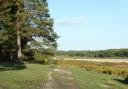
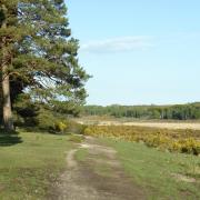
From the village green the walk soon passes The Vine pub before meandering alongside the neighbouring woods of Buckland’s Pightle Copse and English Wood; incidentally, the pub was originally called The Wellington Arms, since it sits on land that once belonged to the estate of the Duke of Wellington. Soon the walk strides out over open fields before dipping down to cross Ibworth Lane and then rising up alongside Gaston Wood.
We then follow surfaced tracks to reach the lofty heights of Plantation Hill before heading west with views to the right over the Kennet Valley and ahead to the large TV mast on Cottington’s Hill. The final leg of the walk heads south past Hannington Scrubs before passing All Saints Church to arrive back at the village green; from here it’s a short walk back to Michael’s Field.
Information
• Start/finish: car park at Michael’s Field along Ibworth Lane in Hannington (SU542554)
• Map: OS Explorer 144
• Distance: 5.25 miles (8.3km)
• Terrain: some gates and no stiles, ups and downs, paths and tracks that can be muddy, and sections of country road
• Time: 2.5 hours
• Refreshments: Hannington – The Vine (01635 298525)
• To find out more about Steve, including his walking books, visit steve-davison.co.uk
The walk
1 (SU542554) – From the parking area at Michael’s Field, exit onto the lane with a thatched cottage opposite and turn right (west) along Ibworth Lane to a junction opposite the village green. Turn left along the road for 275m, passing The Vine pub on the way. Just before The Kennels turn left along the enclosed track for a short way, then turn right along the narrow path. Continue beside the fence, dogleg right through the trees into the field and keep ahead alongside the left-hand margin, with Buckland’s Pightle Copse on the left. At the corner bear right for a short way and then turn left through the hedge gap to a track. Turn left for 20m to a split and fork right to stay in the field, following the track down alongside the left-hand field edge, with English Wood on the left.
2 (SU549545) – Ignore a track to the left and keep ahead to enter a field. Almost immediately, fork left at the signpost and follow the path up across the field; keep ahead over the brow of the hill to the far side. Follow the path down through the trees, go through a small gate and turn left along the lane for 100m. Turn right up the track to a junction with a bridleway at Halves Wood. Turn left and soon leave the trees to follow the fence on the right, keeping the trees of Gaston Wood on the left. Keep ahead to reach a track junction with a wood on the right.
3 (SU549559) – Go straight on down the surfaced track to a lane. Cross over and follow the surfaced track opposite for quarter of a mile heading up Plantation Hill to a track junction a short distance before Plantation Farm. Turn left along the stony track (bridleway) for slightly under half a mile to arrive at a junction; along the way there are views to the right and ahead is the TV mast on Cottington’s Hill.
4 (SU537568) – Turn left down the track (bridleway) staying close to the right-hand side of the field to a dip and then head uphill. Pass Hannington Scrubs to enter a field and turn left along the enclosed path as it soon swings right to continue alongside the field edge. Exit through a small gate, turn right along the lane for 50m and then turn left along a track, following the left-hand field edge. At the far left corner turn left through a small gate and follow the enclosed path as it skirts clockwise round a large barn (private) to join a gravel drive. Turn left to arrive at the village green; just on the right is the entrance to the church. Keep ahead along the lane with the village green on the right to the main street and turn right for a few metres to a junction. Turn left along Ibworth Lane for 250m back to the car park.
More…
• The best walks in Hampshire - With the New Forest, South Downs and a picturesque coastline, Hampshire is an amazing place for a walk. We round up a few of our favourites